

A Good Bit Of Clouds & Rather Cool At Midday, Very Few Raindrops At This Time
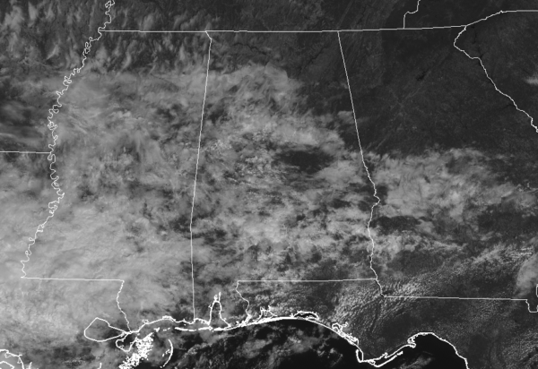
CONDITIONS AT 11:45 AM
Cloud cover over parts of the area is keeping it rather cool over much of the area where it is mild in the southeastern parts. We have just a few very light showers over Pike and Barbour counties in Central Alabama, with only a few more down into South Alabama. No rain near Talladega Superspeedway where they should have no weather issues today. Temperatures are in the lower 60s to the lower 70s. Birmingham was at 64 degrees. A few locations were tied at 63 degrees as the cool spots. The warm spot was Troy at 73 degrees.
REST OF THIS AFTERNOON
Unfortunately for most of Central Alabama, these clouds that are blocking out the sun at times look to stay with us through the rest of the afternoon and into the early evening hours as they will continue streaming in from the west. Much of the area will stay dry unless you are along and south of the US-80 and I-85 corridors in the southern parts of the area where a few isolated to scattered showers are possible. Afternoon highs across the area will top out in the lower 70s to the lower 80s from northwest to southeast. Rain chances over the southern parts are around 20-30% through 7:00 pm.
LATE NIGHT THROUGH THE OVERNIGHT HOURS
Rain chances will be on the increase from the southwest and southern parts of the area towards the north as a warm front will be moving northward through the southern half of Central Alabama during the overnight hours. Rain chances will range from around 20% in the north to nearly 90% in the southwest. Before that, only a few isolated to scattered showers are possible over the southern half of the area with skies becoming cloudy. Lows will be in the upper 50s to the mid-60s.
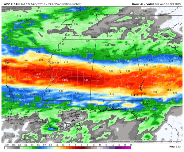
SOME DROUGHT RELIEF ON TUESDAY
While tomorrow’s event will not be drought-busting rainfall, it will help to put a small dent into the deficits across Central Alabama, especially south of the I-20 corridor. Showers and a few embedded thunderstorms will be likely throughout the entire day with most of the heavier rainfall occurring south of a line from Reform to Hoover to Wedowee. While rainfall may not occur all-day long, rain can be expected at any time. Much of the area will see up to 1.00-2.00 inches of rainfall with some localized heavier amounts possibly reaching 3.00 inches. North of the I-20 corridor, amounts will be lighter totaling 0.25 inches to just over 0.50 inches. Highs will be in the upper 60s to the upper 70s.
Category: Alabama's Weather, ALL POSTS
About the Author (Author Profile)
Scott Martin is an operational meteorologist, professional graphic artist, musician, husband, and father. Not only is Scott a member of the National Weather Association, but he is also the Central Alabama Chapter of the NWA president. Scott is also the co-founder of Racecast Weather, which provides forecasts for many racing series across the USA. He also supplies forecasts for the BassMaster Elite Series events including the BassMaster Classic.Subscribe
If you enjoyed this article, subscribe to receive more just like it.


