

Mid-Morning Update on PTC Sixteen: Hurricane Hunters Find Near Hurricane Force Winds But Still Disorganized
Air Force Hurricane Hunters have found maximum flight-level winds of 75 mph in the strong storms well east of the center just after 8 a.m. this morning.
The system is not very organized, with all the thunderstorm activity on the eastern side of the storm. But that activity has greatly increased and that is where the strong wind was just found.
The plane just passed through a wind shift location that must be the center. Pressures were only around 1001 mb. That location is about 350 miles south of Bay St. Louis, Mississippi and about 410 miles southwest of Panama City.
While the storm is not well organized, a large area of tropical-storm-force winds was observed in the thunderstorm mass that is east of the center. It remains to be seen whether it is well organized enough to be considered a tropical or subtropical cyclone, but it is going to deliver very bad weather to the eastern Florida Panhandle, Big Bend area, and West Coast of Florida.
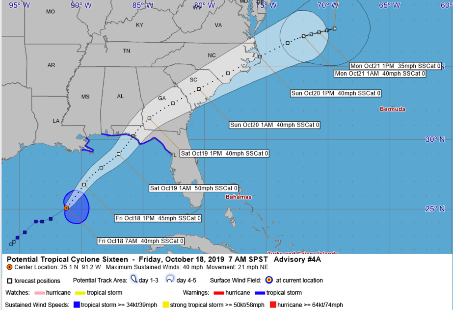
The official forecast shows that the center should make landfall early Saturday morning, around sunrise, between Fort Walton and Apalachicola, likely near Rosemary Beach or Panama City. Top sustained winds at that point are forecast to be around 50 mph.
Model guidance is pretty consistent now.
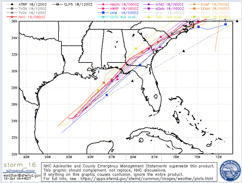
The deterministic Euro shows landfall around 7 a.m. Saturday just east of Destin. The GFS shows landfall just east of Panama City around 4 am.
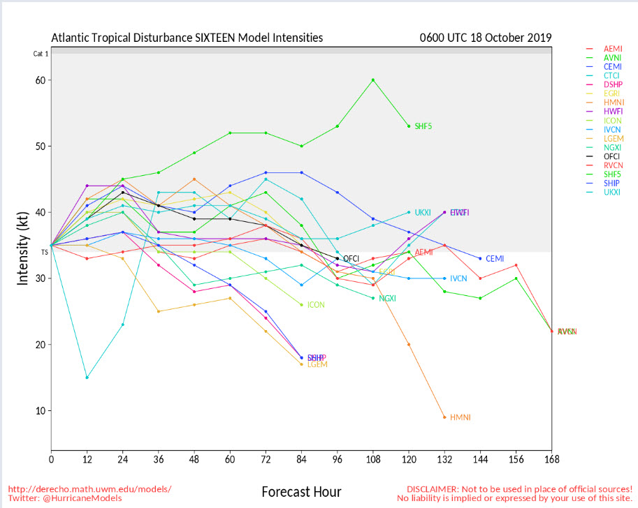
Most of the intensity guidance is in that range, but there will be some stronger winds on that eastern side of the storm.
Tropical-storm-force winds could begin on the coast between Pensacola and Appalachicola around midnight tonight, and perhaps even a little earlier. Tropical storm warnings extend from south of Morgan City in Louisiana through coastal Louisiana, Mississippi, Alabama, and Florida to north of Clearwater.
Strong winds will end quickly along the Northwest Florida beaches Saturday morning as the system moves away.
Rain is already nearing the coast on the outer fringes of the system and rain will be likely today all along the coast from Southeast Louisiana through the Panhandle. Rain amounts will range from around 0.75 inches on the Alabama coast, to around 2 inches at Destin, to around 4 inches at Panama City to over 5 inches at Mexico Beach and Apalachicola. The Tallahassee area should pick up around 2.5 inches and this type of rain will fall up through eastern Georgia, South Carolina, and southeastern North Carolina.
Coastal flood advisories cover the coasts of Southeastern Louisiana, Mississippi, Alabama, and Northwest Florida, along with high surf advisories and advisories for high rip current risk. Along the Alabama coast, surf will rise to 5-7 feet and 1-2 feet of coastal flooding is expected tonight and early Saturday. On the Northwest Florida coast, surf will run 10-13 feet and surge will be 1-3 feet as far east at Indian Pass.
A storm surge warning is in effect south and east of Indian Pass near Apalachicola to Clearwater. Storm surge will be 2-5 feet in teh strom surge warning area, particularly in the Florida Big Bend area.
Tornadoes are unlikely along the Alabama and Northwest Florida coast, but a line of tornadic storms will impact the Big Bend and West Coast of Florida area from east of Apalachicola to the Tampa Bay area tonight after midnight.
CENTRAL ALABAMA IMPACTS
For Central Alabama, the only impacts will be limited to the southeastern quarter of the state. Breezy conditions are expected after midnight tonight through midday Sunday. We may see wind gusts to 20-25 mph this evening across North-central Alabama including places like Anniston and Birmingham. Winds will gust to around 20 mph on Saturday. Winds may gust to 20-40 mph in areas south of I-85 late tonight and Saturday morning. A wind advisory may be needed for parts of southeast Alabama later today.
Rainfall amounts up to an inch are possible for southeast Alabama between tonight and Saturday night with rainfall amounts under an inch elsewhere. Birmingham could pick up a few showers on Saturday morning, but I think most of the rain remains south of I-85. This rainfall is not expected to cause any significant flooding impacts.
Scott will have a special update for Central Alabama around 10:30 a.m. and we will have frequent updates through tomorrow.
About the Author (Author Profile)
Bill Murray is the President of The Weather Factory. He is the site's official weather historian and a weekend forecaster. He also anchors the site's severe weather coverage. Bill Murray is the proud holder of National Weather Association Digital Seal #0001 @wxhistorianSubscribe
If you enjoyed this article, subscribe to receive more just like it.


