

Active Weather Day Ahead For Alabama
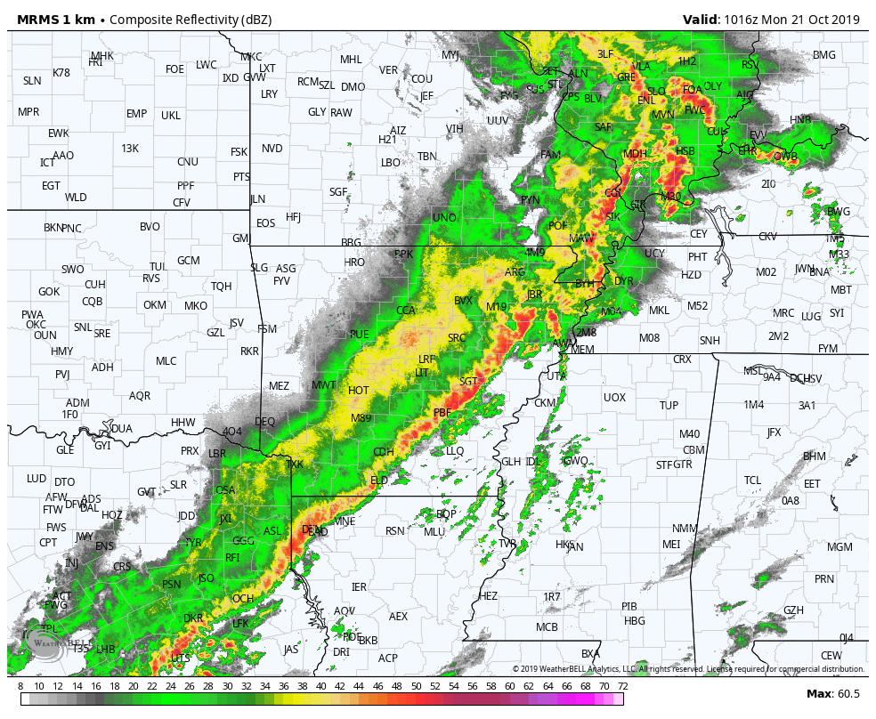
STRONG STORMS LATER TODAY: On the maps this morning, a deep surface low will move from the Great Plains up to the Great Lakes region by tonight, dragging a cold front into Alabama. Early morning strong to severe storms are lined up from Southeast Texas into southern Illinois…
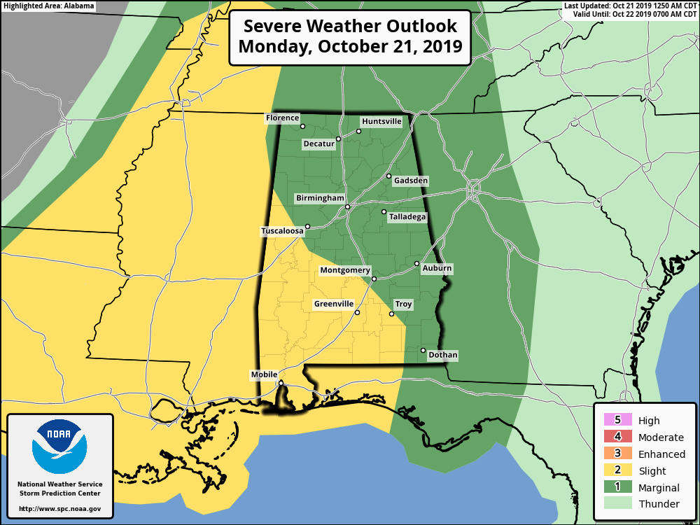
SPC has parts of West and South Alabama in a “slight risk” (level 2/5) of severe storms today, with a “marginal risk” (level 1/5) for the rest of the state.
These storms will weaken and move into Northwest Alabama later this morning. Odds of severe storms over North/Central Alabama look very low during the afternoon as the air will be fairly stable; in fact the first batch of storms should basically dissipate at some point over North Alabama. To the south, storms will maintain their intensity over the southern part of the state, most likely… this is where instability values will be higher.
And, a new line of showers and storms will likely form over North/Central Alabama tonight ahead of the cold front.
The main threat from thunderstorms across Alabama this afternoon and tonight will come from strong, gusty thunderstorm winds, although an isolated, brief tornado can’t be totally ruled out. The bottom line is that the severe weather threat for Alabama is very conditional and marginal, but as always, we will watch thunderstorm development closely.
Rain amounts of 1/4″ to 3/4″ are expected for most places through late tonight.
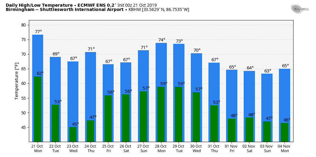
MID-WEEK: Dry weather is the story tomorrow through Thursday with mostly sunny pleasant days and clear chilly nights; highs will be in the low 70s, with lows in the 40s.
FRIDAY AND THE WEEKEND: Model consistency on these three days is pretty much non existent, and the forecast is about as clear as mud. We will forecast a chance of rain late Thursday night and Friday statewide with a wave moving in from the west. The, the American global model (the GFS) basically shows a cool, dry weekend, while the European global model (the ECMWF) shows periods of rain throughout the weekend. For now, we will lean toward the more reliable ECMWF and maintain a chance of rain at times on Saturday, and then trend toward a drier day Sunday. But, understand this forecast can and probably will change as we get closer to the weekend.
NEXT WEEK: Needless to say, confidence is low, but at this point it looks like Monday and Tuesday will be dry, followed by some risk of rain Wednesday or Thursday with an approaching cold front. See the Weather Xtreme video for maps, graphics, and more details.
TROPICS: All is now quiet across the Atlantic basin, and tropical storm formation is not expected this week. The season ends on November 30.
ON THIS DATE IN 1934: A severe windstorm lashed the northern Pacific coast. In Washington State, the storm claimed the lives of 22 persons, and caused 1.7 million dollars damage, mostly to timber. Winds, gusting to 87 mph at North Head, WA, produced waves twenty feet high on the Puget Sound.
BEACH FORECAST: Click here to see the AlabamaWx Beach Forecast Center page.
WEATHER BRAINS: Don’t forget you can listen to our weekly 90 minute show anytime on your favorite podcast app. This is the show all about weather featuring many familiar voices, including our meteorologists here at ABC 33/40.
CONNECT: You can find me on all of the major social networks…
Facebook
Twitter
Instagram
Pinterest
Snapchat: spannwx
I have a weather program this morning at Opelika Middle School… look for the next Weather Xtreme video here by 4:00 this afternoon… enjoy the day!
Category: Alabama's Weather, ALL POSTS, Weather Xtreme Videos
About the Author (Author Profile)
James Spann is one of the most recognized and trusted television meteorologists in the industry. He holds the AMS CCM designation and television seals from the AMS and NWA. He is a past winner of the Broadcast Meteorologist of the Year from both professional organizations.Subscribe
If you enjoyed this article, subscribe to receive more just like it.


