

Possible Watch Coming Soon For Southwestern Alabama
From the Storm Prediction Center…
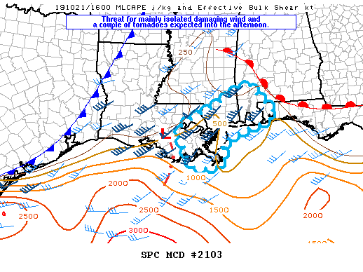
The threat for isolated damaging wind and a couple of tornadoes should persist into the afternoon along the central Gulf Coast region from southeast LA through southeast AL and the far western FL Panhandle. Trends are being monitored for a watch.
Late this morning an MCV embedded within a general area of rain is located west of the New Orleans area, moving east northeast. Storms have intensified over southeast LA within zone of convergence south of the MCV. Diabatic heating of the moist boundary layer with temperatures warming into the low to mid 80s F is occurring east of the thicker cirrus plume across the central Gulf Coast region, but MLCAPE should remain below 1000 J/kg due to moist adiabatic mid-level lapse rates. The primary low-level jet is forecast to shift north of the more unstable portion of the warm sector, but a weaker secondary low-level jet associated with the MCV will maintain low-level hodographs (150-200 m2/s2 storm relative helicity) sufficient for a few embedded low-level mesocyclones. However, the dominant convective mode will probably remain linear. Some intensification of the line may occur as it moves into a destabilizing boundary layer, supporting a threat for isolated strong to damaging wind gusts and a couple of tornadoes this afternoon.
Category: Alabama's Weather, ALL POSTS, Severe Weather
About the Author (Author Profile)
Scott Martin is an operational meteorologist, professional graphic artist, musician, husband, and father. Not only is Scott a member of the National Weather Association, but he is also the Central Alabama Chapter of the NWA president. Scott is also the co-founder of Racecast Weather, which provides forecasts for many racing series across the USA. He also supplies forecasts for the BassMaster Elite Series events including the BassMaster Classic.Subscribe
If you enjoyed this article, subscribe to receive more just like it.


