

SPC Removes Slight Risk From Much Of Central Alabama, Marginal Risk Still In Place
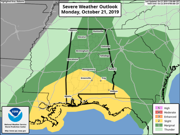
The Storm Prediction Center is agreeing more with Central Alabama on the severe weather threats for today and has decided to reduce the risk to Marginal for much of Central Alabama. A Slight Risk is still up for the extreme southern parts of the area (south of a line from Demopolis to Selma to Louisville).
Here is the latest on the severe weather threat from the Storm Prediction Center…
Severe thunderstorms remain possible across the Deep South through this afternoon and tonight, primarily along the Gulf Coast from southeast Louisiana into southern portions of Mississippi/Alabama and the Florida Panhandle. Damaging wind gusts and a couple tornadoes are possible.
Last night’s extensive/severe-active squall line continues to exhibit considerable downward organizational and intensity trends late this morning, with the unperturbed richer warm/moist sector effectively confined to southern portions of Louisiana/Mississippi to southwest Alabama and the western Florida Panhandle at late morning. An MCS is ongoing over the open waters of the Gulf of Mexico south of Louisiana, with the north edge of this MCS developing northeastward into coastal southeast Louisiana at this time. Ascent including a possible MCV related to this squall line appears likely to focus the most probable severe risk along the Gulf Coast this afternoon into tonight, in conjunction with moisture-rich maritime air related to the northward/inland advance of a warm front. As additional diurnal destabilization occurs and the warm/moist sector moves northward, strengthening deep-layer flow and moderately strong low-level shear/SRH will support a mixed convective mode including supercells and linear bowing segments. Damaging winds and a couple of tornadoes are possible into tonight as storms generally transition east-northeastward across the region.
Category: Alabama's Weather, ALL POSTS, Severe Weather
About the Author (Author Profile)
Scott Martin is an operational meteorologist, professional graphic artist, musician, husband, and father. Not only is Scott a member of the National Weather Association, but he is also the Central Alabama Chapter of the NWA president. Scott is also the co-founder of Racecast Weather, which provides forecasts for many racing series across the USA. He also supplies forecasts for the BassMaster Elite Series events including the BassMaster Classic.Subscribe
If you enjoyed this article, subscribe to receive more just like it.


