

The Midday Check On Our Weather Situation
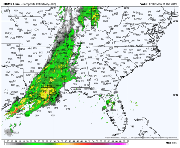
Radar at 12:10 pm shows a weakening line of showers moving into the western parts of Central Alabama and the weakening trend should continue as it moves east. We’ll have to watch and see if we have any redevelopment back to the west just ahead of the cold front. We’ll also have to watch and see if storm development over the Gulf Coast cuts off the flow of energy from reaching Central Alabama and reducing our severe storm risks.
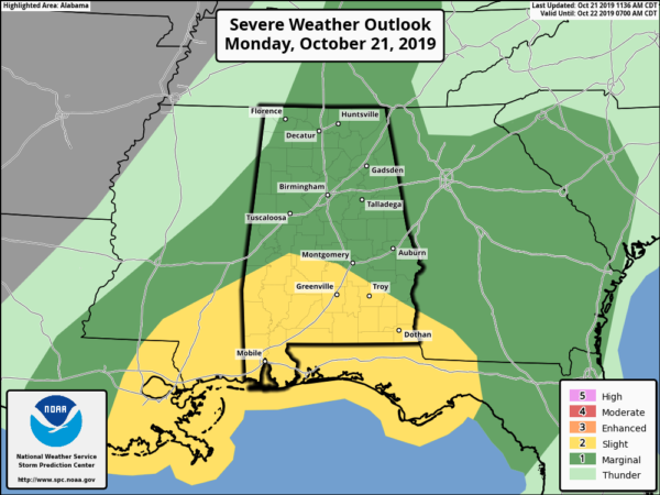
The Storm Prediction Center has decided to reduce the risk to Marginal for much of Central Alabama. A Slight Risk is still up for the extreme southern parts of the area (south of a line from Demopolis to Selma to Louisville). The air will be more unstable over the southern half of the state as storms developing in those parts will cut the flow of energy from reaching the northern half of the state.
With that being said, we still can not rule out a few strong to severe storms across Central Alabama as we’ll have enough shear to support storms that do develop. If we get any breaks in the clouds to allow for instability to build, isolated damaging winds and a brief tornado or two will be possible but not likely.
Timing remains the same with the main window for strong to severe thunderstorms continue to be from noon today to midnight tonight. West of a line from Hanceville to Brookwood to Demopolis will be from 12:00 pm to 5:00 pm. East of that to a line stretching from Fruithurst to Alexander City to Fort Deposit will be from 4:00 pm to 8:00 pm. East of that will be from 7:00 pm to 12:00 am.
Rain and thunderstorms will be likely as the front approaches and moves across the area throughout the second half of the day, but some showers are possible earlier. With the warm air advection, highs will get up into the mid-70s to the lower 80s. Rain should be out of the area just before sunrise on Tuesday, but a few lingering showers may remain in the extreme southeastern parts of the area. Lows will be in the upper 40s to the lower 60s across the area from northwest to southeast.
Now, we just sit back and watch to see if we do get any breaks in the clouds and if we get any energy up here from the south. Can we see a few severe thunderstorms in Central Alabama… sure we can. Can the storms in the south keep severe development from occurring in Central Alabama… yes. We’ll keep you updated throughout the rest of the day.
Tuesday will be an outstanding day across Central Alabama as all rain should be out of the area before sunrise. Skies will clear out very early and we’ll be left with cobalt blue skies during the daylight hours. Afternoon highs will be in the upper 60s to the mid-70s.
THE TROPICS
The Atlantic Basin is quiet at this point and no tropical cyclones are expected to develop through the next five days.
Category: Alabama's Weather, ALL POSTS, Severe Weather
About the Author (Author Profile)
Scott Martin is an operational meteorologist, professional graphic artist, musician, husband, and father. Not only is Scott a member of the National Weather Association, but he is also the Central Alabama Chapter of the NWA president. Scott is also the co-founder of Racecast Weather, which provides forecasts for many racing series across the USA. He also supplies forecasts for the BassMaster Elite Series events including the BassMaster Classic.Subscribe
If you enjoyed this article, subscribe to receive more just like it.


