

Wet Weather Returns To Alabama Tomorrow
**No afternoon Weather Xtreme video; I am live on ABC 33/40 at the Hoover Hayride at Veterans Park**
CIRRUS NEAR US, STRATUS COMING AT US: Another delightful fall day for Alabama; lots of sunshine today through high altitude cirrus clouds, around 25,000 feet off the ground. These thin clouds are ice crystals, and often are seen ahead of a storm system that features lower stratus clouds. The lower clouds arrive tonight.
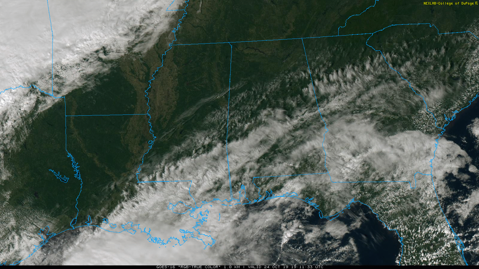
TOMORROW: Widespread rain is likely during the day as a warm front slowly moves northward. Temperatures will hold in the 60s as the rain falls. There could be a little thunder in spots, but we expect mostly a large stratiform rain mass. The rain will likely continue over North Alabama tomorrow night, while South Alabama gets a break from the rain.
SATURDAY: The warm front will move to near the Tennessee state line, and all of Alabama will be in a moist airmass. Occasional showers are likely during the day, but it is important to note that it won’t rain all day, and the sun might even peek out at time or two. Not a total “wash out”. Then, late in the day and into Saturday night, a band of thunderstorms will roll through ahead of a cold front. Instability will be limited, and lapse rates rather weak, so for now we are not expecting organized severe storms. But, a strong thunderstorm will certainly be possible.
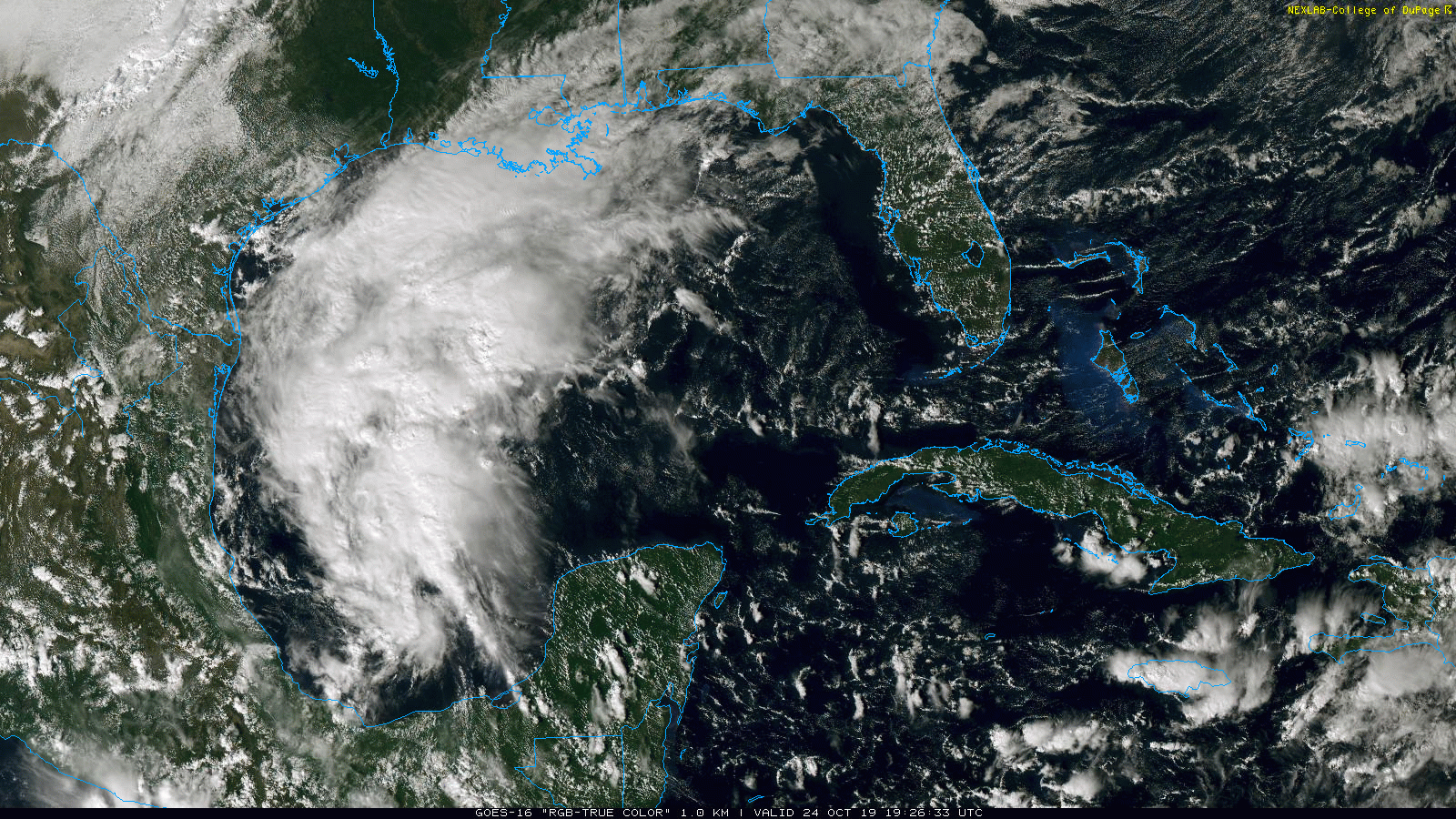
The rain will most likely be heavy at times as a tropical system, now in the Gulf of Mexico, is now expected to be involved; for now it looks like the heaviest rain will fall over North and West Alabama, where 2-4 inches are likely. One to two inches are expected for the southern and eastern part of the state, but these forecast amounts could change as we get better clarity on the tropical situation.
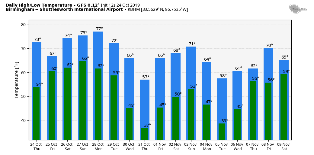
The high Saturday afternoon will be in the mid 70s.
SUNDAY: Morning clouds will give way to a partly sunny afternoon; any lingering showers should be confined to the southern quarter of the state. Sunday’s high will be in the low 70s.
NEXT WEEK: A decent part of the week will be dry, but models are showing mixed signals concerning precipitation along a cold front at mid-week. We are still expecting the coldest air so far this season following the front, with potential for the first freeze of the season for some North/Central Alabama communities late in the week.
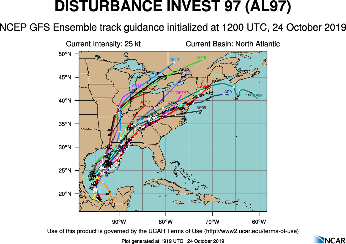
TROPICS: The disturbance over the Gulf of Mexico (Invest 97L) now has a 60 percent chance of becoming a tropical depression or storm over the next 36 hours. It will merge with a cold front tomorrow night and Saturday, and the deep moisture will move into Alabama and the Gulf Coast region, enhancing rain amounts.
FOOTBALL WEATHER: For the high school games tomorrow night, the sky will be cloudy with rain likely over the northern third of Alabama; temperatures will be in the 60s. Showers will be more scattered in nature over the southern 2/3 of the state.
For Saturday’s Magic City Classic at Legion Field in Birmingham (Alabama State vs Alabama A&M, 2:30p CT kickoff), the sky will be cloudy, and occasional showers are likely. A thunderstorm can’t be ruled out, but there will be good breaks in the rain. Kickoff temperature near 74 degrees, falling to near 70 by the final whistle.
Auburn travels to Baton Rouge Saturday to take on LSU (2:30p CT kickoff)… the sky will be mostly cloudy, and a few passing showers are possible during the game. Temperatures will fall from the upper 60s at kickoff into the mid 60s by the fourth quarter.
It is homecoming at the University of Alabama Saturday; the Tide will host Arkansas at Bryant-Denny Stadium (6:00p CT kickoff). It looks like rain will fall at times, with thunderstorms possible as well. Temperatures will fall from near 72 at kickoff, into the upper 60s by the second half.
Jacksonville State will host Murray State Saturday (3:00p CT kickoff)… cloudy conditions are expected with some rain possible; temperatures will be in the low 70s during the game.
ON THIS DATE IN 1878: The Gale of 1878 was an intense Category 2 hurricane that was active between October 18 and October 25. It caused extensive damage from Cuba to New England. Believed to be the strongest storm to hit the Washington – Baltimore region since hurricane records began in 1851.
BEACH FORECAST: Click here to see the AlabamaWx Beach Forecast Center page.
WEATHER BRAINS: Don’t forget you can listen to our weekly 90 minute show anytime on your favorite podcast app. This is the show all about weather featuring many familiar voices, including our meteorologists here at ABC 33/40.
CONNECT: You can find me on all of the major social networks…
Facebook
Twitter
Instagram
Pinterest
Snapchat: spannwx
I had a great time today at Clay County Christian Academy… be looking for them on the Pepsi KIDCAM today at 5:00 on ABC 33/40 News! The next Weather Xtreme video will be posted here by 7:00 a.m. tomorrow…
Category: Alabama's Weather, ALL POSTS
About the Author (Author Profile)
James Spann is one of the most recognized and trusted television meteorologists in the industry. He holds the AMS CCM designation and television seals from the AMS and NWA. He is a past winner of the Broadcast Meteorologist of the Year from both professional organizations.Subscribe
If you enjoyed this article, subscribe to receive more just like it.


