

Marginal Severe Storms Threat Continues For Late Tonight Through The Overnight
The latest update is out from the Storm Prediction Center and we continue to have a Marginal Risk (level 1 of 5) up for the entire state of Alabama for the overnight and into the morning hours on Friday.
We still have the low-probability risks of a few isolated damaging thunderstorm wind gusts up to 60 MPH and a brief tornado or two. There is the possibility that the Storm Prediction Center may upgrade portions of the area into a Slight Risk (level 2 of 5), but we’ll have to wait and see with further updates.
A surface low wil be lifting northward into Tennessee along with a few impulses that may allow for some scattered showers and thunderstorms to develop during the rest of the afternoon and into the evening hours. There may be some instability available, but with no real lifting source and weaker lapse rates, strong to severe storms will remain unlikely.
There may be a break in the rainfall out ahead of the front that may lead to more instability to build across the area, and with the shear that will be moving into the area with the low-level jet and the approaching front, there is a small risk of damaging winds and a smaller threat of a brief tornado or two.
TIMING: The cold front will begin to push into the state in the 12am-2am time frame, reaching the central parts of the area in the 6am-9am time frame, and pushing south and east of the I-85 corridor by 9am-12pm.
• From locations along and west of a line from Geiger to Jasper to Vinemont – 12:00 am to 4:00 am.
• East of that to a line stretching from Orrville to Chelsea to Gadsden – 3:00 am to 7:00 am.
• East of that to a line stretching from Hayneville to Alexander City to Ranburne – 6:00 am to 10:00 am.
• East of that to the AL/GA state line – only isolated strong storms possible but not likely at this point.
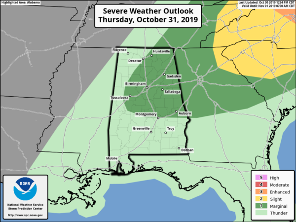
That is why the Storm Prediction Center has the eastern 2/3rds of Central Alabama in a Marginal Risk for severe storms on Thursday. The good news is that the severe threat will come to an end by 10am-12pm.
What we’ll have to look forward to after that is the Freeze Watches that have been issued for all of North Alabama and the northern counties of Central Alabama, where we could see low temperatures below the freezing mark on Friday morning.
Category: Alabama's Weather, ALL POSTS, Severe Weather
About the Author (Author Profile)
Scott Martin is an operational meteorologist, professional graphic artist, musician, husband, and father. Not only is Scott a member of the National Weather Association, but he is also the Central Alabama Chapter of the NWA president. Scott is also the co-founder of Racecast Weather, which provides forecasts for many racing series across the USA. He also supplies forecasts for the BassMaster Elite Series events including the BassMaster Classic.Subscribe
If you enjoyed this article, subscribe to receive more just like it.


