

Early Evening Check On Our Weather Situation
We currently have a warm front lifting northward through the area and moisture levels are continuing to increase as precipitable water values are now at or above 2.00 inches. While a few showers and an occasional thunderstorm are possible throughout the evening and into the late-night hours, most of Central Alabama should stay dry until the front approaches from the west.
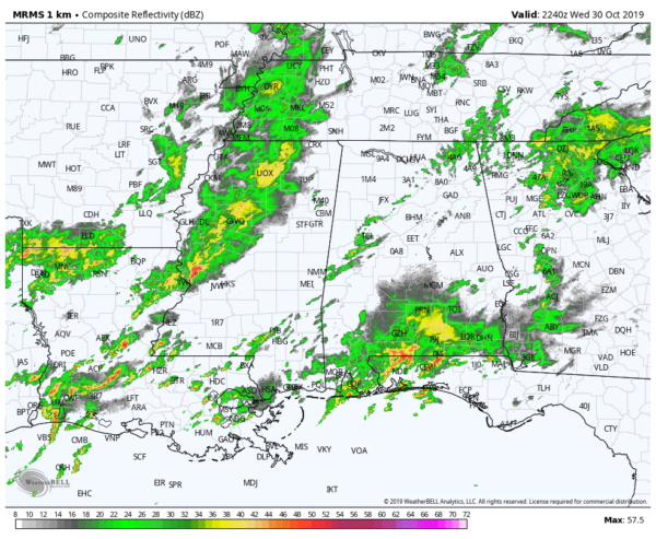
There are a few showers over the western parts of the area, especially west of the I-59/20 corridor. A few of these are putting down some decent rainfall, but most are light to moderate in nature.
The cold front is currently located to the west near the Mississippi River with a line of showers and thunderstorms just in front of it. At this point, there are no severe warnings issued with the front, but that doesn’t mean we are out of the woods yet.
The low-level jet will increase to over 50 knots later tonight just ahead of the front. We’ll have an increase in bulk shear across the area, and with temperatures remaining in the 60s and 70s, instability values will remain elevated. The limiting factor will be the weak lapse rates as they will prevent strong or persistent updrafts.
Timing hasn’t changed from the earlier update… The cold front will begin to push into the state in the 12am-2am time frame, reaching the central parts of the area in the 6am-9am time frame, and pushing south and east of the I-85 corridor by 9am-12pm.
• From locations along and west of a line from Geiger to Jasper to Vinemont – 12:00 am to 4:00 am.
• East of that to a line stretching from Orrville to Chelsea to Gadsden – 3:00 am to 7:00 am.
• East of that to a line stretching from Hayneville to Alexander City to Ranburne – 6:00 am to 10:00 am.
• East of that to the AL/GA state line – only isolated strong storms possible but not likely at this point.
We’ll have updates on the blog throughout the night and into the morning hours. Stay tuned.
Category: Alabama's Weather, ALL POSTS, Severe Weather
About the Author (Author Profile)
Scott Martin is an operational meteorologist, professional graphic artist, musician, husband, and father. Not only is Scott a member of the National Weather Association, but he is also the Central Alabama Chapter of the NWA president. Scott is also the co-founder of Racecast Weather, which provides forecasts for many racing series across the USA. He also supplies forecasts for the BassMaster Elite Series events including the BassMaster Classic.Subscribe
If you enjoyed this article, subscribe to receive more just like it.


