

Cool Weekend, Becoming More Mild By Midweek
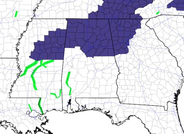
FREEZE WARNINGS AND FROST ADVISORIES
Freeze warnings continue in effect for the northern half of Central Alabama and all of North Alabama until 9:00 am this morning. Frost advisories continue for most of the southern half of Central Alabama until 9:00 am as well.
FANTASTIC BUT COOL SATURDAY
It will be a fantastic day across Central Alabama with plenty of blue skies with maybe one or two passing clouds. It will remain cool today with highs reaching the mid-50s to the lower 60s across the area. We’ll have clear skies tonight which will allow those lows to drop into the lower to mid-30s for most with upper 30s for locations along and south of I-85. A freeze watch has been issued for roughly the northern half of Central Alabama tonight that will go through 8:00 am on Sunday.
TIME CHANGE
Don’t forget we go back on standard time this weekend; set your clocks back one hour before you go to bed tonight. The sunset Sunday at Birmingham will be at 4:53 pm CST.
A NEAR REPEAT ON SUNDAY
Sunday will be another fantastic but cool day across the area, but there will be just a couple more clouds in the sky during the late afternoon through the evening hours. We’ll have plenty of sunshine with highs in the upper 50s to the lower 60s.
EVEN WARMER ON MONDAY
The first day of the workweek will remain dry but we’ll have some clouds mixed in with some sun throughout the day. Temperatures will be warmer making it up into the 60s across the area.
WARMING TREND CONTINUES ON TUESDAY
The trend of warming temperatures will continue for Tuesday as there will be mostly sunny skies for the northern half of the area, with partly to mostly cloudy skies for the southern half. We stay dry and highs will be in the mid-60s to the lower 70s.
VERY NICE DAY ON WEDNESDAY
Another warmer day on Wednesday as we can expect mostly sunny skies. We will have clouds start to move in during the late-night and overnight hours ahead of a cold front, but we should stay dry. Afternoon highs will be in the upper 60s to the mid-70s.
SHOWERS POSSIBLE ON THURSDAY
A cold front will move through the area on Thursday that will bring us a decent chance of showers. At this point, it looks like there won’t be that much moisture with this system, and thunder doesn’t look to be likely as there will be no surface instability. The best rain chances will be from the late morning through the evening hours, but rain will be out of the area well before midnight. Highs will be in the lower 60s to the lower 70s across the area.
BACK TO COOLER TEMPERATURES ON FRIDAY
Clouds will be decreasing during the day but some will continue to hang tough. We’ll end up with partly cloudy skies by the afternoon and our temperatures will be much cooler. Highs will be down in the lower 50s to the lower 60s.
A VOODOO LAND LOOK AT NEXT SATURDAY
I have heard that there may be this big football game taking place in Tuscaloosa starting at 2:30 pm CT on next Saturday. Well, taking a peek into Voodoo Land, the weather looks to be great with cool temperatures. It’ll be dry with plenty of sunshine and temperatures in the lower 60s to start, then falling into the upper 50s by the 4th quarter.
THE TROPICS
The Atlantic Basin is free from any tropical waves or disturbances that are of any concern and no new tropical cyclones are expected to form within the next five days.
ON THIS DAY IN WEATHER HISTORY
1961 – The temperature at Atlanta, GA, reached 84 degrees to establish a record for November.
BEACH FORECAST
Get the latest weather and rip current forecasts for the beaches from Bay St. Louis, MS, to Panama City Beach, FL, on our Beach Forecast Center page. There, you can select the forecast of the region that you are interested in.
ALREADY OFF TO A HOT START IN 2019! ADVERTISE WITH THE BLOG!
After a record-setting 2018 with nearly 20 million page views, AlabamaWx.com is already well on its way to another great year as we’ve just topped 14.7 million page views so far in 2019! Don’t miss out! We can customize a creative, flexible and affordable package that will suit your organization’s needs. Contact Bill Murray at (205) 687-0782.
E-FORECAST
Get the Alabama Wx Weather Blog’s Seven-Day Forecast delivered directly to your inbox by email twice daily. It is the most detailed weather forecast available in Central Alabama. Subscribe here… It’s free!
CONNECT WITH THE BLOG ON SOCIAL MEDIA
You can find the AlabamaWx Weather Blog on the major social media networks:
Facebook
Twitter
Instagram
WEATHERBRAINS
Don’t forget you can listen to our weekly 90 minute netcast anytime on the web at WeatherBrains.com or on Apple Podcasts, Stitcher, or Spotify. This is the show all about weather featuring many familiar voices, including the meteorologists at ABC 33/40.
Category: Alabama's Weather, ALL POSTS, Weather Xtreme Videos
About the Author (Author Profile)
Scott Martin is an operational meteorologist, professional graphic artist, musician, husband, and father. Not only is Scott a member of the National Weather Association, but he is also the Central Alabama Chapter of the NWA president. Scott is also the co-founder of Racecast Weather, which provides forecasts for many racing series across the USA. He also supplies forecasts for the BassMaster Elite Series events including the BassMaster Classic.Subscribe
If you enjoyed this article, subscribe to receive more just like it.


