

A Very Nice Saturday, An Even Nicer Sunday
VERY CHILLY START TO YOUR SATURDAY
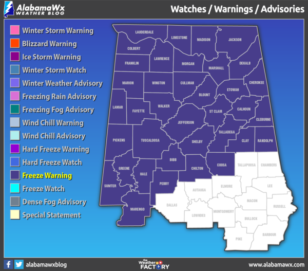
After starting off with below-freezing temperatures and a Freeze Warning for most of Central Alabama and all of North Alabama that will expire at 8:00 am, we’ll have plenty of sunshine on your Saturday with afternoon highs reaching the mid-50s to the lower 60s across the area from northwest to southeast. Skies will remain clear and those temperatures will drop into the mid to upper 30s for the overnight lows.
A LITTLE WARMER ON SUNDAY
We’ll continue to have near-complete sunshine through the day on Sunday as we’ll have high pressure just off to our southeast. Temperatures will be warmer as the flow will be out of the south and southwest. Afternoon highs will be in the mid to upper 60s.
COLD FRONT HEADS OUR WAY TO START THE WORK WEEK
Clouds will be on the increase throughout the day on Monday as a strong cold front will be bringing our next chance of showers. Showers look to start as early as late evening in the west and northwestern parts of the area, and into the Birmingham metropolitan area by midnight. The cold front will begin working through Central Alabama during the overnight hours bringing the colder air and breezy conditions. Afternoon highs will top out in the lower 60s to the lower 70s across the area, but those lows will drop into the lower 30s to the upper 40s. Rainfall amounts through midnight look to be light, around 1/4 inch or less.
RAIN ENDS WITH MUCH COLDER & WINDY CONDITIONS ON TUESDAY
Tuesday looks to be just a raw and nasty day across Central Alabama. Showers will be in the process of exiting the area and should be out of Central Alabama completely by midday. There may be a few snow flurries or sleet pellets on the backside of the rain, but there will be no travel issues at all. Rainfall amounts should stay around 1/4 inch or less across the area. Winds will be out of the north around 15 MPH with gusts as high as 30 MPH possible, which will make those afternoon highs in the mid-30s to the upper 40s feel much worse. The coldest night we will see so far this season will occur Tuesday night into Wednesday morning as lows will drop down into the upper teens to the upper 20s across the area from north to south.
ONLY A LITTLE BETTER ON WEDNESDAY
High pressure will be centered off to our northwest over the southwestern parts of Tennessee. That will continue to bring us cool and dry weather on Wednesday. We’ll have plenty of sunshine throughout the daylight hours but clouds will be on the increase during the late-night and overnight hours. Highs will be in the mid-40s to the lower 50s.
WE STAY DRY ON THURSDAY EVEN THOUGH IT WILL BE MOSTLY CLOUDY
As the high moves off over the east-central parts of North Carolina, the flow will be out of the southwest on Thursday and that will start to pull some moisture up from the Gulf of Mexico. There will be a low over the northern Gulf that will be moving northeastward. We may see a stray shower or two over the extreme southern parts of the area very late in the day, but nearly all of Central Alabama will stay dry. Highs will be in the upper 40s to the mid-50s.
A FEW SHOWERS POSSIBLE TO END THE WORK WEEK
On Friday, the low will move onshore over the Big Bend region of the Florida Panhandle. With it being in that close proximity to Central Alabama, we could see some spotty light showers move across the southern half of the area mainly during the late morning through the late-night hours. Highs will be in the lower 50s to the lower 60s across the area.
THE TROPICS
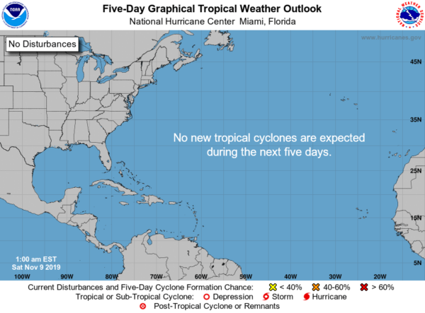
The Atlantic Basin is free from any tropical waves or disturbances that are of any concern and no new tropical cyclones are expected to form within the next five days.
ON THIS DAY IN WEATHER HISTORY
1926 – A tornado in Charles County of southern Maryland killed seventeen persons.
1982 – Seven tornadoes touched down in southern California, three of which began as waterspouts. The waterspouts moved ashore at Point Mugu, Malibu, and Long Beach. The Long Beach tornado traveled inland ten miles causing much damage.
BEACH FORECAST
Get the latest weather and rip current forecasts for the beaches from Bay St. Louis, MS, to Panama City Beach, FL, on our Beach Forecast Center page. There, you can select the forecast of the region that you are interested in.
ALREADY OFF TO A HOT START IN 2019! ADVERTISE WITH THE BLOG!
After a record-setting 2018 with nearly 20 million page views, AlabamaWx.com is already well on its way to another great year as we’ve just topped 14.7 million page views so far in 2019! Don’t miss out! We can customize a creative, flexible and affordable package that will suit your organization’s needs. Contact Bill Murray at (205) 687-0782.
E-FORECAST
Get the Alabama Wx Weather Blog’s Seven-Day Forecast delivered directly to your inbox by email twice daily. It is the most detailed weather forecast available in Central Alabama. Subscribe here… It’s free!
CONNECT WITH THE BLOG ON SOCIAL MEDIA
You can find the AlabamaWx Weather Blog on the major social media networks:
Facebook
Twitter
Instagram
WEATHERBRAINS
Don’t forget you can listen to our weekly 90 minute netcast anytime on the web at WeatherBrains.com or on Apple Podcasts, Stitcher, or Spotify. This is the show all about weather featuring many familiar voices, including the meteorologists at ABC 33/40.
Category: Alabama's Weather, ALL POSTS, Weather Xtreme Videos, Winter Weather
About the Author (Author Profile)
Scott Martin is an operational meteorologist, professional graphic artist, musician, husband, and father. Not only is Scott a member of the National Weather Association, but he is also the Central Alabama Chapter of the NWA president. Scott is also the co-founder of Racecast Weather, which provides forecasts for many racing series across the USA. He also supplies forecasts for the BassMaster Elite Series events including the BassMaster Classic.Subscribe
If you enjoyed this article, subscribe to receive more just like it.


