

Nice Weather Continues For Today & Through Much Of The Week
TODAY: We’ll have mostly sunny skies for much of the day, but at times there will be enough clouds to make it partly cloudy. Afternoon highs will top out in the upper 50s to the mid-60s across the area. Skies will be mostly clear for tonight through the overnight hours. Lows will drop into the mid-30s to the lower 40s.
MONDAY: We’ll continue to stay dry on Monday but we’ll have even more clouds move across Central Alabama. It will be partly to mostly cloudy at times with highs reaching the lower 50s to the lower 60s.
TUESDAY: The quiet weather trend continues on Tuesday as most of those clouds will move out of the area and we’ll be left with mostly sunny skies throughout the day. Highs will be in the 60s across the area.
WEDNESDAY: We’ll stay dry on Wednesday, plus it will be just a little warmer. Skies will be mostly sunny to partly cloudy and highs will be in the mid-60s to the lower 70s across Central Alabama.
THURSDAY: A cold front will be approaching from the west on Thursday that will send clouds into Central Alabama. At this point, we look to stay dry with mostly cloudy skies as ridging over the southeast will keep the rain north of the state. Afternoon highs will be in the mid-60s to the lower 70s.
FRIDAY: The ridging will push off to the east and will allow the cold front to move into Central Alabama on Friday, bringing a decent chance of showers to the area. At this point, rain chances will be around 20-40% across the area from southeast to northwest. Not everyone will see rain, but rainfall amounts look to range from a trace to as high as just over 1 inch from southeast to northwest. Thunder does not look likely as there is no instability to work with. Highs will be in the lower 60s to the lower 70s.
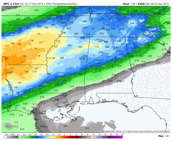
SATURDAY: The cold front will continue to push through the remainder of the area on Saturday which will keep a chance of showers in the forecast through the early evening hours. There may be just enough instability for a few claps of thunder, but no severe weather is expected at this time. Highs will be in the upper 50s to the upper 60s. A good bit of rainfall is expected as the latest QPF chart from the WPC shows amounts in the 1/2-inch to 1 1/2-inch range across Central Alabama.
NEXT SUNDAY: A quick peek into Voodoo Land for next Sunday shows that dry weather returns to Central Alabama with clearing skies. Highs look to top out in the 50s across the area.
TROPICS: We do have one area of concern that has formed a few hundred miles to the northeast of the Leeward Islands. It will be no threat to land as it will move northwest and north over the open waters of the Atlantic and eventually merging with a frontal system near the end of the week. Some slow development is expected but the NHC is only giving it a low chance of forming a tropical cyclone before it merges with the system. The rest of the Atlantic Basin is quiet.
Category: Alabama's Weather, ALL POSTS, Weather Xtreme Videos
About the Author (Author Profile)
Scott Martin is an operational meteorologist, professional graphic artist, musician, husband, and father. Not only is Scott a member of the National Weather Association, but he is also the Central Alabama Chapter of the NWA president. Scott is also the co-founder of Racecast Weather, which provides forecasts for many racing series across the USA. He also supplies forecasts for the BassMaster Elite Series events including the BassMaster Classic.Subscribe
If you enjoyed this article, subscribe to receive more just like it.


