

Fine Fall Weather
For the rest of today, we will continue to see sunshine in full supply and blue sky all across Alabama. After the chilly start to the day, we have rebounded nicely with upper 50s and lower 60s late this morning. By the end of the day, we should see highs generally in the mid 60s for most of North/Central Alabama. More of the same highlights the forecast tomorrow and Thursday; expect more sun than clouds with warming temperatures. Highs will go from to those mid 60s today, to upper 60s tomorrow, to lower 70s Thursday. Nights will remain chilly with 30s and 40s expected.
A METEOR OUTBURST COULD HAPPEN THIS WEEK: Get ready for a meteor outburst–maybe. Later this week, Earth will pass by a stream of dusty debris from an unnamed comet. Forecasters believe this could cause an outburst of alpha Monocerotid meteors on Thursday night/Friday morning (Nov. 21-22).
RAIN RETURNS TO END WEEK: A cold front approaching from the north will bring rain to the northern half of the state Friday afternoon and Friday night. A wave of low pressure is expected to move along the front, enhancing rain chances Friday night into early Saturday morning. The air looks to remain stable so we are not expecting thunderstorms, and no severe weather. Rain amounts around one inch will be likely.
IN THE TROPICS: Most of the Atlantic a quiet, but we do now have Tropical Storm Sebastien, which formed this morning. At 1100 AM AST, the center of Tropical Storm Sebastien was located near latitude 20.1 North, longitude 58.7 West. Sebastien is moving toward the north-northwest near 8 mph. A turn to the north is expected on Wednesday followed by a turn to the northeast and an increase in forward speed Wednesday night.
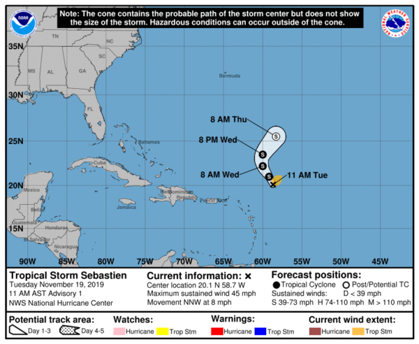
Maximum sustained winds are near 45 mph with higher gusts. Some slight strengthening is possible over the next day or so. Sebastien is expected to become absorbed by a cold front in a couple of days. Tropical-storm-force winds extend outward up to 105 miles from the center. The estimated minimum central pressure is 1008 mb (29.77 inches). Remember, hurricane season ends on November 30th.
BEACH FORECAST CENTER: Get the latest weather and rip current forecasts for the beaches from Fort Morgan to Panama City on our Beach Forecast Center page. There, you can select the forecast of the region that you are interested in visiting.
WORLD TEMPERATURE EXTREMES: Over the last 24 hours, the highest observation outside the U.S. was 111.6F at Leonora Aero, Australia. The lowest observation was -55.5F at Dome A, Antarctica.
CONTIGUOUS TEMPERATURE EXTREMES: Over the last 24 hours, the highest observation was 97F at Roblar Canyon and Santee, CA. The lowest observation was 11F at Alamosa, CO.
WEATHER ON THIS DATE IN 1921: The Columbia Gorge ice storm finally came to an end. In Oregon, 54 inches of snow, sleet and glaze blocked the Columbia River Highway at the Dalles. Apart from traffic on the river itself, all transportation between Walla Walla, WA and Portland, OR came to a halt. Nine trains were stopped as railroads were blocked for several days.
Category: Alabama's Weather, ALL POSTS
About the Author (Author Profile)
Macon, Georgia Television Chief Meteorologist, Birmingham native, and long time Contributor on AlabamaWX. Stormchaser. I did not choose Weather, it chose Me. College Football Fanatic. @Ryan_StinnetSubscribe
If you enjoyed this article, subscribe to receive more just like it.


