

Clouds Increasing; Some Rain At Mid-Afternoon
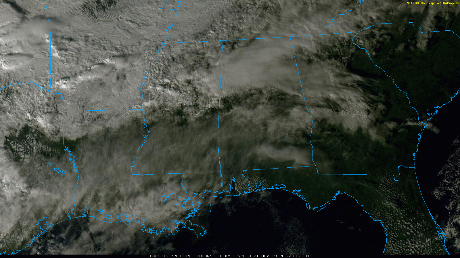
CLOUDS; SOME RAIN: We have some “illegal” patches of rain across North Alabama this afternoon (the forecast was for dry conditions today)… the rain seems to be ahead of a surface boundary that has formed around I-59 that is lifting slowly northward. The sky is mostly cloudy over the northern half of the state, with a mix of sun and clouds over South Alabama. Temperatures are mostly in the 60s. The light rain over North Alabama should move northward into Tennessee this evening.
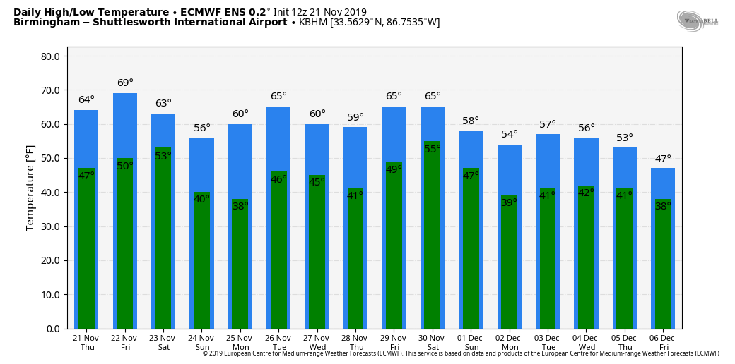
TOMORROW AND THE WEEKEND: The sky will stay cloudy tomorrow, and rain will likely begin over the northern and western counties by afternoon. Periods of rain are likely statewide tomorrow night into Saturday as a cold front slowly approaches. Some thunder is possible, but severe storms are not expected with little to no surface based instability. Rain amounts will be around one inch, and the rain will end from northwest to southeast during the midday and afternoon hours Saturday. Temperatures Saturday will be in the 60s.
Sunday will be dry; the sky becomes mostly sunny, and the day will be cooler with a high around 60 degrees.
THANKSGIVING WEEK: Monday will be dry with a good supply of sunshine; after a low in the 30s the high will be in the mid 60s. Clouds increase Tuesday, and some rain is likely Tuesday night with a cold front through the state. Models continue to trend toward a less amplified solution, meaning rain won’t be too heavy, and there is no risk of severe storms. The sky will clear during the day Wednesday, and for now the weather looks dry Thanksgiving Day and Black Friday. The high Wednesday will be in the 57-60 degree range, and then back in the low to mid 60s Thursday and Friday. See the Weather Xtreme video for maps, graphics, and more details.
METEOR SHOWER TONIGHT: The alpha Monocerotid meteor shower has potential to bring a brief burst of activity tonight at 10:50 p.m. CT tonight, but you should start watching for potential meteors starting at about 10:25 p.m. CT. A band of clouds will likely impact viewing over Alabama in a negative way.
TROPICS: Tropical Storm Sebastien, in the Atlantic north of the Leeward Islands, is expected to briefly become a hurricane tomorrow before becoming post-tropical this weekend. The system will approach the Azores by Sunday, well to the east of North America.
FOOTBALL WEATHER: For the high school playoff games tomorrow night, periods of rain are likely with temperatures in the 60s.
Saturday, Alabama hosts Western Carolina (11:00a CT kickoff) at Bryant-Denny Stadium; there is a decent chance the wet weather will be over in time for kickoff, but some light rain or drizzle could linger into the first quarter. Otherwise, the sky will be mostly cloudy with temperatures in the 60s.
Auburn will host Samford Saturday morning at Jordan-Hare Stadium (11:00a CT kickoff)… periods of rain are likely with temperatures in the mid 60s.
UAB hosts Louisiana Tech Saturday at Legion Field (2:30p CT kickoff)… a very good chance the rain will be over by kickoff; the sky will be cloudy with a kickoff temperature near 64 degrees, falling back into the low 60s by the fourth quarter.
Jacksonville State will host Eastern Kentucky Saturday (1:00p CT kickoff); some rain will remain possible during the first quarter. The sky will be cloudy with temperatures in the 60s.
ON THIS DATE IN 1992: The November 21-23 tornado outbreak in 1992 was the 3rd largest outbreak in recorded history and one of the longest continuous outbreaks ever recorded. There was no break in tornado activity from 1:30 pm on the 21st when the tornadoes started in Texas until 7:30 am on the 23rd when the last tornadoes lifted in North Carolina. On this date, severe thunderstorms spawned six tornadoes within 70 minutes in the Houston metro area in Texas. At one time, there were three on the ground in Harris County. The strongest, an F4, tracked 20 miles through the eastern suburbs of Houston destroying 200 homes and damaging 1,000 more. In total, 23 tornadoes struck Mississippi and Alabama. An F4 tornado killed 12 people on a 128-mile track through 7 Mississippi counties. The deadliest tornado of 1992, an F4 tornado killed 12 people on a 128-mile path through 7 counties in Mississippi, one of the bodies was blown a quarter mile into a tree. In Alabama, 13 tornadoes touched down, injuring dozens of people. One of them moved through parts of Etowah and DeKalb counties, injuring 12 people in Sardis City.
BEACH FORECAST: Click here to see the AlabamaWx Beach Forecast Center page.
WEATHER BRAINS: Don’t forget you can listen to our weekly 90 minute show anytime on your favorite podcast app. This is the show all about weather featuring many familiar voices, including our meteorologists here at ABC 33/40.
CONNECT: You can find me on all of the major social networks…
Facebook
Twitter
Instagram
Pinterest
Snapchat: spannwx
Look for the next Weather Xtreme video here by 7:00 a.m. tomorrow…
Category: Alabama's Weather, ALL POSTS, Weather Xtreme Videos
About the Author (Author Profile)
James Spann is one of the most recognized and trusted television meteorologists in the industry. He holds the AMS CCM designation and television seals from the AMS and NWA. He is a past winner of the Broadcast Meteorologist of the Year from both professional organizations.Subscribe
If you enjoyed this article, subscribe to receive more just like it.


