

Showers Continue Just North Of I-59 As We Approach Midday
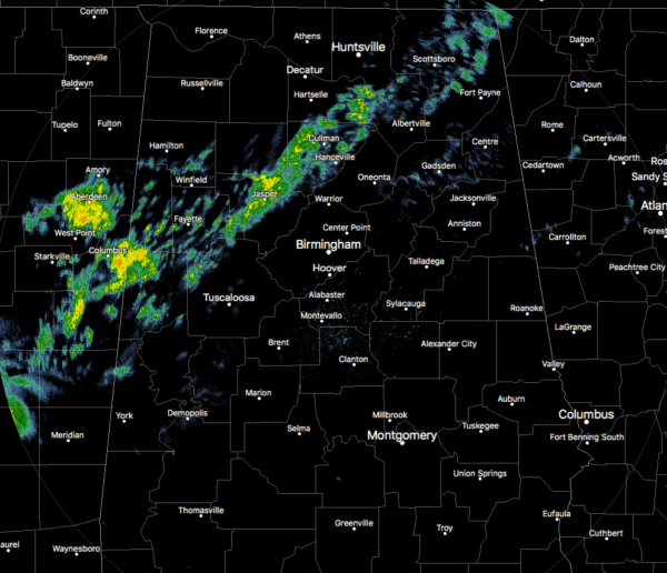
As we approach the midday hour across Central Alabama, we continue to have some light to moderate shower activity north of the I-59 corridor with the rest of the area south of that remaining dry.

Skies across the northwestern two-thirds of Central Alabama currently is covered with a good bit of cloud cover even where the rain is not occurring. The southeastern-third of the area currently has mostly clear skies with just a few clouds moving overhead. That will change as we move through the day as the cloud cover will continue to progress eastward.
Temperatures at the 11:00 am hour are in the upper 50s to the mid-70s across Central Alabama. Here is a quick look at temperatures:
Alexander City: 67°F
Anniston: 65°F
Auburn: 64°F
Bessemer: 66°F
Birmingham: 67°F
Demopolis: 70°F
Gadsden: 61°F
Haleyville: 59°F
Marion: 72°F
Montgomery: 74°F
Pell City: 63°F
Prattville: 68°F
Selma: 72°F
Shelby Co Airport: 69°F
Sylacauga: 70°F
Talladega: 66°F
Troy: 71°F
Tuscaloosa: 68°F
For the rest of the afternoon hours and into the evening rush hour, the higher rain chances will remain along and north of I-59 while some showers will be possible south of that to roughly the I-85 corridor in the southeastern parts of the area. No thunder is expected. Afternoon highs will be in the lower 60s to the lower 70s across the area from northwest to southeast.
Rain chances will slowly increase throughout the evening and into the late night hours as a cold front approaches the area, with rain likely along and north of I-59 and decreasing as you move southeastward towards the I-85 corridor. Temperatures will start off in the upper 50s to the mid-60s across the area at 6:00 pm and will only drop a degree or two by the late local news tonight.
During the overnight hours, the cold front will begin to move into the northwestern parts of the area and progress slowly to the east and southeast. Some thunder will be possible, but no severe storms are expected. Everyone across the area will have a chance of rain and storms. Rain will be likely north of a line from Selma to Clanton to Alexander City, while chances decrease as you move southeast. Lows will be in the upper 50s to the lower 60s.

The front will continue to push across Central Alabama during the day on Saturday with showers and a few thunderstorms likely for much of the area. Rain chances will come to an end for the northwestern parts of the area by the early afternoon hours, for the I-59 corridor around the mid-afternoon hours, and for the rest of the area by the early evening hours. Afternoon highs will top out in the upper 50s to the lower 70s across the area. Total rainfall amounts from now through the end of Saturday is forecast to range from roughly 1/2-inch in the south and southeast to as high as 1 1/2 inches in the north and northeast.
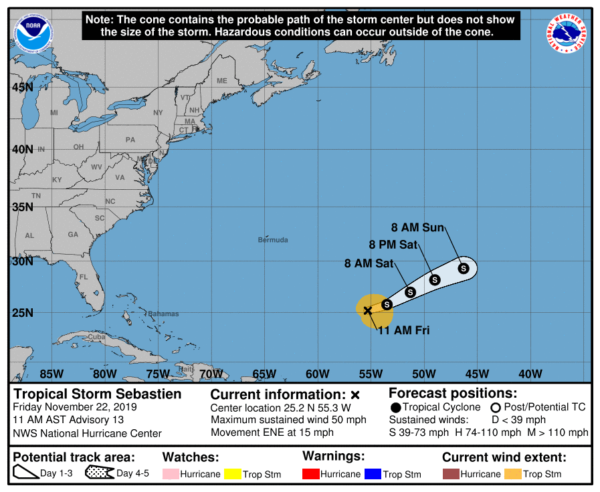
Tropical Storm Sebastien is poorly organized at this point as it continues to move to the east-northeast over the open waters of the central Atlantic Ocean. Shear is increasing as a frontal system approaches. At this point, gradual weakening should start and Sebastien should dissipate within three days or so.
Category: Alabama's Weather, ALL POSTS, Tropical
About the Author (Author Profile)
Scott Martin is an operational meteorologist, professional graphic artist, musician, husband, and father. Not only is Scott a member of the National Weather Association, but he is also the Central Alabama Chapter of the NWA president. Scott is also the co-founder of Racecast Weather, which provides forecasts for many racing series across the USA. He also supplies forecasts for the BassMaster Elite Series events including the BassMaster Classic.Subscribe
If you enjoyed this article, subscribe to receive more just like it.


