

Heads Up Greene & Sumter Counties For Strong Storms
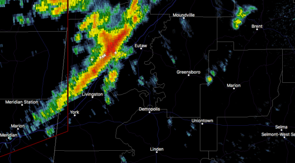
At 1052 PM CST, Doppler radar was tracking strong thunderstorms along
a line extending from near Mantua to near Epes to near Zero. Movement
was east at 40 mph.
Wind gusts of 40 to 50 mph will be possible with these storms.
Locations impacted include…
Demopolis, Livingston, Eutaw, York, Cuba, Forkland, Boligee, Union,
Gainesville, Epes, Walden Quarters, West Greene, The University Of
West Alabama, Thornhill, Dug Hill, Tishabee, Boyd, Mantua, Allison
and Jena.
PRECAUTIONARY/PREPAREDNESS ACTIONS…
To report severe weather, contact your nearest law enforcement
agency. They will relay your report to the National Weather Service
office in Birmingham.
Category: Alabama's Weather, ALL POSTS, Severe Weather
About the Author (Author Profile)
Scott Martin is an operational meteorologist, professional graphic artist, musician, husband, and father. Not only is Scott a member of the National Weather Association, but he is also the Central Alabama Chapter of the NWA president. Scott is also the co-founder of Racecast Weather, which provides forecasts for many racing series across the USA. He also supplies forecasts for the BassMaster Elite Series events including the BassMaster Classic.Subscribe
If you enjoyed this article, subscribe to receive more just like it.


