

Snow Is Falling In Some Locations In North Alabama, Cold Rain For Central Alabama At 1:00 PM
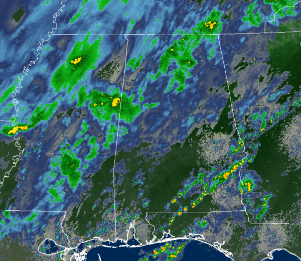
As of 1:00 pm, we continue to have rain falling over a good bit of Central Alabama, but there is now falling in parts of North Alabama. The latest reports from NWS Chat show that up in the northwestern corner of the state that snow is definitely falling in locations such as Elgin and Center Star. We have seen photos on Twitter of a few locations (Waterloo, Anderson, and Rogersville) that have a light dusting on grassy surfaces along with some decks and porches. No travel issue at this point and none are expected through the remainder of the day. Snow is now reported in Madison, Elkmont, and a few flurries in Cullman.
Temperatures are in the mid-30s to the mid-60s across Central Alabama from northwest to southeast. Haleyville was the cold spot at 36 degrees with light rain. The warm spot was Troy at 65 degrees with cloudy skies. Birmingham has dropped to 47 degrees with light rain.
Other than the Significant Weather Advisory that was issued earlier for the counties in North Alabama for the potential of light snow, no watches or warnings are in effect for North and Central Alabama.
Pretty much the same story as the late morning report… The changeover is continuing to occur over the northwest and northern parts of North Alabama. It looks like a nice band of snow may set up over the north and northwestern parts of North Alabama that may extend into the northwest corner of Central Alabama around 5:00 pm. This band will shrink as we continue through the evening and into the late-night hours with all wintry precipitation coming to an end by midnight.
During that brief window of heavier snowfall in that band (from roughly 5:00 pm to 10:00 pm), we could see some minor accumulations in grassy locations, maybe as much as 1/10th of an inch, in the northwestern parts of Central Alabama (possibly all of Marion and Winston counties, along with the northern parts of Lamar, Fayette, Walker, Cullman, Blount, Etowah, and Cherokee counties). No worries with travel issues with the snow as anything that does stick will not last long as temperatures will still be above freezing at that point.
What we’ll have to watch for is the potential for flash-freezing of any liquid remaining on elevated surfaces in the higher elevations of the extreme northern parts of Central Alabama during the pre-dawn hours on Wednesday. Temperatures north of a line from Fayette to Birmingham to Anniston will drop below the freezing point. No travel issues are expected on roadways as surface temperatures will remain well above freezing. Plus, any ice that does form on those elevated surfaces will quickly melt as we’ll have full sunshine and temperatures will quickly climb above freezing by 8:00 am.
Category: ALL POSTS
About the Author (Author Profile)
Scott Martin is an operational meteorologist, professional graphic artist, musician, husband, and father. Not only is Scott a member of the National Weather Association, but he is also the Central Alabama Chapter of the NWA president. Scott is also the co-founder of Racecast Weather, which provides forecasts for many racing series across the USA. He also supplies forecasts for the BassMaster Elite Series events including the BassMaster Classic.Subscribe
If you enjoyed this article, subscribe to receive more just like it.


