

A Quick Update On Our Weather Just Before 6:00 PM
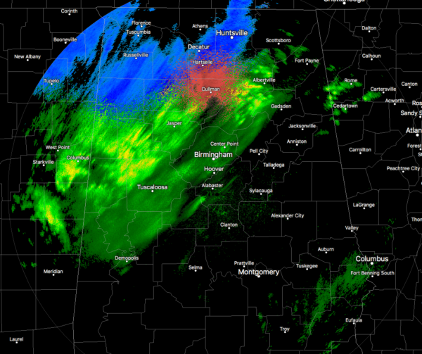
As of 5:45 PM, much of the activity remains contained along and north of the I-59 corridor at this time with snow and some sleet falling over the northern and northwestern parts of North Alabama and into the northwestern parts of Central Alabama. Only some very light sprinkles are falling over the southeastern parts of the area along and south of the I-85 corridor.
Temperatures were down in the lower 30s to the lower 50s across the area from northwest to southeast. Haleyville was already down to 30 degrees and Cullman was at 32 degrees. Birmingham was at 37 degrees. Montgomery was the warm spot at 52 degrees.
For Central Alabama: Light snow and sleet mixed with rain will be possible through 2 AM along and north of a line from Vernon to Warrior to Centre. Snow accumulations up to a half-inch and a trace of sleet will be possible in grassy areas. The only impacts will be the potential for leftover water on roadways to freeze overnight as temperatures fall below freezing in these areas.
For North Alabama: Widespread swath of either a mixture of light rain and snow or light
snow continues to move eastward across the Tennessee Valley in the wake of a cold frontal passage earlier today. Some light accumulations around one-half inch to one inch have been reported across parts of the area within the last hour. Some additional light snowfall accumulations near one-half inch are possible over the next couple of hours, as this light snowfall continues to spread eastward. The wintry precipitation is expected to gradually taper off from the west heading into the evening hours, with snowfall likely coming to an end across northeast Alabama near midnight.
These light accumulations are impacting a few roads and elevated surfaces, and a few slick spots cannot be ruled out into the overnight hours. Motorists should continue to use caution this evening while traveling, especially on bridges and overpasses.
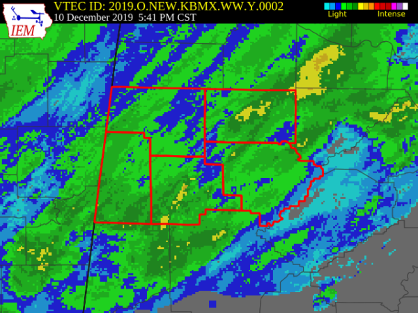
A Winter Weather Advisory continues in effect for Fayette, Lamar, Marion, Walker, and Winston counties until 2:00 am Wednesday. Some snow expected with the potential of total snow accumulations of up to one-half inch. Some slick spots on roadways (mainly on lesser-traveled roads and on overpasses.
Temperatures will rise above freezing between 8:00 am and 10:00 am Wednesday morning, with dry conditions and sunny skies expected for the rest of the day.
SCHOOL DELAYS ON WEDNESDAY MORNING
Blount County Schools: Delayed 2 hours
Cullman City Schools: Delayed 2 hours
Cullman County Schools: Delayed 2 hours
Haleyville City Schools: Delayed 2 hours
Oneonta City Schools: Delayed 2 hours
St Clair County Schools: Delayed 2 hours
Category: Alabama's Weather, ALL POSTS, Winter Weather
About the Author (Author Profile)
Scott Martin is an operational meteorologist, professional graphic artist, musician, husband, and father. Not only is Scott a member of the National Weather Association, but he is also the Central Alabama Chapter of the NWA president. Scott is also the co-founder of Racecast Weather, which provides forecasts for many racing series across the USA. He also supplies forecasts for the BassMaster Elite Series events including the BassMaster Classic.Subscribe
If you enjoyed this article, subscribe to receive more just like it.


