

Slick Spots Possible On Bridges, Overpasses, & In The Higher Terrain
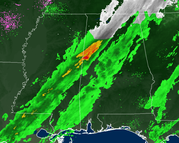
As we approach the 10 o’clock hour on this Tuesday night, we continue to have a good bit of rain moving across the northwestern 2/3rds of the state with snow falling roughly northeast of a line from Vernon to Fayette to Sumiton. We have some heavier rain over the northern parts of Pickens County and northwestern parts of Tuscaloosa County. The bands of precipitation are moving to the east while the cells within the bands are moving quickly to the northeast.
Temperatures are hovering around the freezing mark in Haleyville and Cullman, while it’s just a few degrees warmer at 36 degrees in Birmingham. The mid to upper 40s can still be found in the southeastern parts of Central Alabama.
Precipitation has come to an end over the northwestern corner of the state, mainly west of a line from Sulligent to Haleyville to Rogersville.
NWS Huntsville reported earlier that it had a total of 1.2 inches at their office. 1 inch was reported at Redstone Arsenal, 0.8 inches reported in Monrovia, and 0.3 inches reported at the Huntsville International Airport. We have also received a report of a possible 1 inch of snow accumulation in Haleyville. So far, no reports of any travel issues due to tonight’s event.
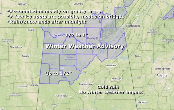
WINTER WEATHER ADVISORIES
A Winter Weather Advisory has expired at 10:00 pm for Colbert, Franklin, Lauderdale, and Lawrence counties.
A Winter Weather Advisory continues for Cullman, DeKalb, Jackson, Limestone, Madison, Marshall, and Morgan counties until 1:00 am Wednesday. Snow accumulations of 1/2 to 1 inch.
A Winter Weather Advisory continues for Fayette, Lamar, Marion, Walker, and Winston counties until 2:00 am Wednesday. Snow accumulations up to 1/2 inch.
NORTH ALABAMA:
Subfreezing temperatures will spread into the Tennessee Valley late tonight behind the departing wintry precipitation to the east. Any lingering moisture on roadways will be subject to freezing, mainly on bridges and overpasses, and in the higher elevations of southern middle Tennessee and northeast Alabama. These slick spots and black ice may result in hazardous driving conditions through Wednesday morning. Motorists should exercise caution when traveling late tonight into Wednesday morning, and be on alert for any slick spots. Temperatures are expected to climb above freezing between 8 and 10 AM Wednesday morning, which should alleviate the threat for slick spots and black ice.
CENTRAL ALABAMA:
Light snow and sleet mixed with rain will be possible through 2:00 AM along and north of a line from Vernon to Warrior to Centre. Snow accumulations up to a half-inch and a trace of sleet will be possible in grassy areas. The only impacts will be the potential for leftover water on roadways to freeze overnight as temperatures fall below freezing in these areas. South and east of the winter weather advisory locations, just expect a cold rain with no weather impact.
SCHOOL DELAYS:
Attalla City Schools: Delayed 2 hours
Blount County Schools: Delayed 2 hours
Cullman City Schools: Delayed 2 hours
Cullman County Schools: Delayed 2 hours
Etowah County Schools: Delayed 2 hours
Fayette Christian Academy: Delayed 2 hours
Fayette County Schools: Delayed 2 hours
Haleyville City Schools: Delayed 2 hours
Jasper City Schools: Delayed 2 hours
Marion County Schools: Delayed 2 hours
Oneonta City Schools: Delayed 2 hours
St Clair County Schools: Delayed 2 hours
Sumiton Christian School: Delayed 2 hours
Walker County Schools: Delayed 2 hours
Westbrook Christian School: Opening at 9:45 AM
Winfield City Schools: Delayed 1 hour; staff report at 8:00
Category: Alabama's Weather, ALL POSTS, Winter Weather
About the Author (Author Profile)
Scott Martin is an operational meteorologist, professional graphic artist, musician, husband, and father. Not only is Scott a member of the National Weather Association, but he is also the Central Alabama Chapter of the NWA president. Scott is also the co-founder of Racecast Weather, which provides forecasts for many racing series across the USA. He also supplies forecasts for the BassMaster Elite Series events including the BassMaster Classic.Subscribe
If you enjoyed this article, subscribe to receive more just like it.


