


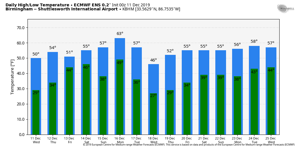
DRY AIR RETURNS: In the wake of the storm system that brought rain and snow to Alabama yesterday and last night, a drier airmass is in place this morning. We expect a good supply of sunshine today with a high close to 50 degrees; the average high for Birmingham on December 11 is 57. Tonight will be fair and cold with a low in the low 30s, then we stay cool and dry tomorrow with a high in the low 50s. The sky will be mostly sunny tomorrow morning, but clouds will increase later in the day.
RAIN RETURNS: Rain will likely enter Alabama after midnight tomorrow night as a wave of low pressure moves out of the Gulf of Mexico. Then, we expect periods of rain Friday and Friday night. Temperatures will be in the 50s Friday, so the air will be stable and there is no risk of severe storms. Probably not much thunder. Rain amounts will be in the 1/2 to 1 inch range for most communities.
THE ALABAMA WEEKEND: Some lingering light rain is possible early Saturday, but the day looks generally dry with a high close to 60 degrees. The sky will remain mostly cloudy during the morning, but some sun is likely by afternoon as drier air works back into the state. Then, on Sunday, the sky will be partly to mostly sunny with a high in the 60s.
NEXT WEEK: The wave train keeps cranking them out, the next rain event will come late Monday, Monday night, and early Tuesday with a cold front moving through. This should bring rain amounts of 1/2 to 3/4″, and while we could hear some thunder, it is not a severe weather look. Colder air moves in Tuesday and daytime temperatures will most likely be in the 40s. The rest of the week looks dry with cool days and chilly nights… See the Weather Xtreme video for maps, graphics, and more details.
TUESDAY’S SOAKER: Rain totals yesterday included…
Remlap 2.80″
Black Creek 2.34″
Morris 2.04″
Arley 1.96″
Coker 1.10″
Concord 1.05″
Bibbville 1.01″
Crestwood 0.85″
Northport 0.74″
Heflin 0.52″
Weaver 0.38″
Snow amounts over the northern quarter of the state were mostly between 1/2 and 1 inch on grassy areas.
ON THIS DATE IN 1961: An EF3 tornado moved through Jacksonville, producing damage on the campus of Jacksonville State University.
ON THIS DATE IN 1992: A complex storm system moved eastward from the Gulf Coast of Texas to eastern Georgia on December 9 and 10th. In the next 24 hours, the low-pressure system moved to the Chesapeake Bay and rapidly intensified. This system produced gale force winds with gusts exceeding hurricane force affected not only the Mid-Atlantic coastline but also as far southwest as the southern Appalachians where trees were downed and roofs damaged. This storm also produced 20 to 30-foot waves in Massachusetts on December 12 and 13th. Precipitation amounts varied considerably. Rainfall amounts of 8 inches occurred in southeastern Massachusetts, while several areas in New York, Massachusetts, Pennsylvania, and Maryland recorded more than 30 inche
BEACH FORECAST: Click here to see the AlabamaWx Beach Forecast Center page.
WEATHER BRAINS: Don’t forget you can listen to our weekly 90 minute show anytime on your favorite podcast app. This is the show all about weather featuring many familiar voices, including our meteorologists here at ABC 33/40.
CONNECT: You can find me on all of the major social networks…
Facebook
Twitter
Instagram
Pinterest
Snapchat: spannwx
Look for the next Weather Xtreme video here by 4:00 this afternoon… enjoy the day!


