

Clouds/Rain To Return To Alabama Later Today/Tonight
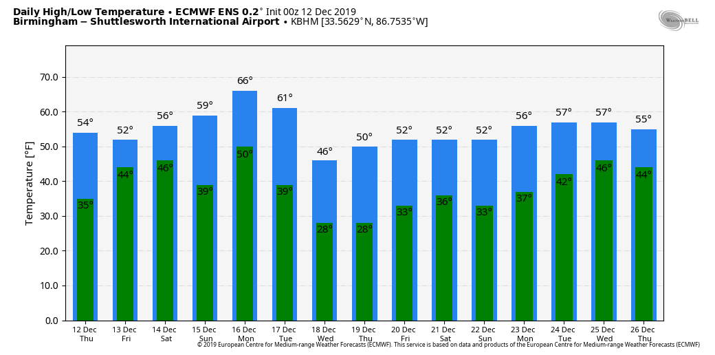
MORE CHANGES AHEAD: After a sunny start, clouds will increase across Alabama today, and some rain is possible over the eastern and southern counties of the state by afternoon and tonight. Best chance of rain later today will be in areas south and east of Birmingham. The high today will be in the mid 50s, not far from average values for December 12.
Tomorrow will be a cloudy, chilly, and wet day with periods of rain and temperatures holding in the 40s much of the day for the northern half of the state as a wave of low pressure moves northeast out of the Gulf of Mexico. No risk of severe storms, and little, if any thunder. Rain amounts of around 1/2 inch are likely over the next 36 hours.
THE ALABAMA WEEKEND: Lingering clouds Saturday morning should give way to a partly sunny afternoon; the high will be in the low 60s. Then, on Sunday, the sky will be partly to mostly sunny with a high between 60 and 64 degrees.
NEXT WEEK: A rather dynamic weather system will bring rain and thunderstorms back into Alabama Monday and Monday night. New data from global models suggest an unstable airmass will be in place, with a high in the low 70s Monday afternoon. SPC has defined a risk of severe thunderstorms for parts of North and West Alabama already in their “Day 5” severe weather outlook….
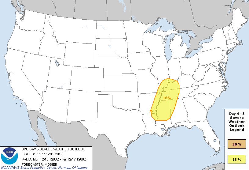
It is too early to define the specific threats and timing, but something to watch over the next few days.
Storms end late Monday night or early Tuesday, and much colder air moves into the state for mid-week. Temperatures hold in the 40s all day Tuesday, and we drop into the 20s early Wednesday morning. The next rain producing system for the state arrives by Friday or Saturday (December 20/21). See the Weather Xtreme video for maps, graphics, and more details.
RAIN UPDATE: Here are rain totals for the year so far, along with departure from average…
Mobile 59.61″ (-3.25″)
Tuscaloosa 57.74″ (+7.86″)
Huntsville 54.71″ (+3.95″)
Anniston 50.25″ (+3.09″)
Birmingham 49.08″ (-1.96″)
Montgomery 42.53″ (-7.50″)
ON THIS DATE IN 1967: From December 12th through the 20th, Flagstaff, Arizona, a series of snowstorms buries Flagstaff with nearly 85 inches of snow.
BEACH FORECAST: Click here to see the AlabamaWx Beach Forecast Center page.
WEATHER BRAINS: Don’t forget you can listen to our weekly 90 minute show anytime on your favorite podcast app. This is the show all about weather featuring many familiar voices, including our meteorologists here at ABC 33/40.
CONNECT: You can find me on all of the major social networks…
Facebook
Twitter
Instagram
Pinterest
Snapchat: spannwx
I have a program this morning at Vernon Intermediate School in Lamar County… look for the next Weather Xtreme video here by 4:00 this afternoon. Enjoy the day!
Category: Alabama's Weather, ALL POSTS, Weather Xtreme Videos
About the Author (Author Profile)
James Spann is one of the most recognized and trusted television meteorologists in the industry. He holds the AMS CCM designation and television seals from the AMS and NWA. He is a past winner of the Broadcast Meteorologist of the Year from both professional organizations.Subscribe
If you enjoyed this article, subscribe to receive more just like it.


