

Strong To Severe Storm Potential For Monday Is Now Coming Into Better Focus
Some Small Changes To The Outlook For Monday Night’s Severe Weather Threat
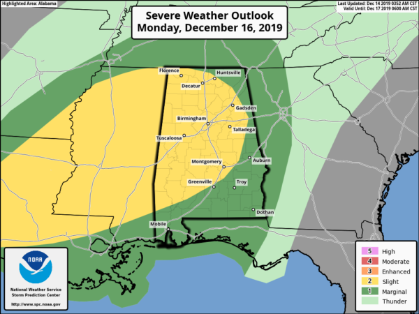
While the Storm Prediction Center continues to keep the Day 3 Outlook similar to what was posted earlier this morning, NWS Birmingham has extended the Slight Risk for severe storms (level 2 of 5) to include all locations west of a line from Troy (Pike Co.) to Smiths Station (Lee Co.). East of that line continues in a Marginal Risk for severe storms (level 1 of 5).
The main window for stronger to severe storms has been pushed back a couple of hours, going from 4:00 pm Monday afternoon to 4:00 am Tuesday morning. To break that down a little further, the western parts of the area (west of a line from West Point (Cullman Co.) to Northport (Tuscaloosa Co.) to Forkland (Greene Co.)) from 4:00 pm to 8:00 pm. East of that to a line stretching from Piedmont (Calhoun Co.) to Goodwater (Coosa Co.) to Fort Deposit (Lowndes Co.) will be from 6:00 pm to midnight). For the rest of the eastern and southeastern parts of the area will be from 10:00 pm to 4:00 am.
All modes of severe weather will be possible: tornadoes, damaging winds up to and possibly exceeding 60 MPH, and large hail up to 1-inch in diameter and possibly larger. Those threats will be higher in the Slight Risk locations, while the threats will be less likely in the Marginal Risk locations.
The Setup
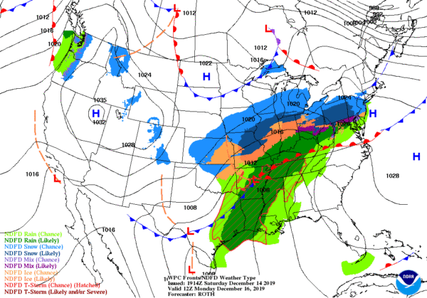
A strong low-pressure system will begin the morning located over the east-central parts of Arkansas and will be moving to the northeast throughout the day. It will be dragging a cold front with it that will eventually move into Central Alabama late in the evening on Monday and sweep across during the overnight and into the early morning hours on Tuesday. Out ahead of that front, warm and moist air will be pulled up from the Gulf of Mexico that will raise those temperatures into the lower to mid-70s across the area with dewpoints reaching the lower to mid-60s.
With the temperatures and dewpoints reaching those levels, that will help the atmosphere to become unstable, especially if we have any sunshine throughout the morning and into the early afternoon hours. Usually, with these late in the year type storms, we’ll have plenty of shear but not a lot of instability. Unfortunately, this time it appears that we may have a decent amount of instability to help thunderstorms develop, especially with an approaching front being a main lifting mechanism.
A Quick Look At The 18z Run Of The Hi-Res NAM Forecast Model
The following images are taken from the 18z (12:00 pm) run of the high-resolution NAM with each image valid at 12:00 am on Tuesday morning. I will go ahead and say that the NAM is usually a little more robust with the values so all of these may be a touch high, but they clearly show that we will need to keep our eyes open for severe storms throughout the night-time and overnight hours.
SURFACE-BASED INSTABILITY (CAPE)
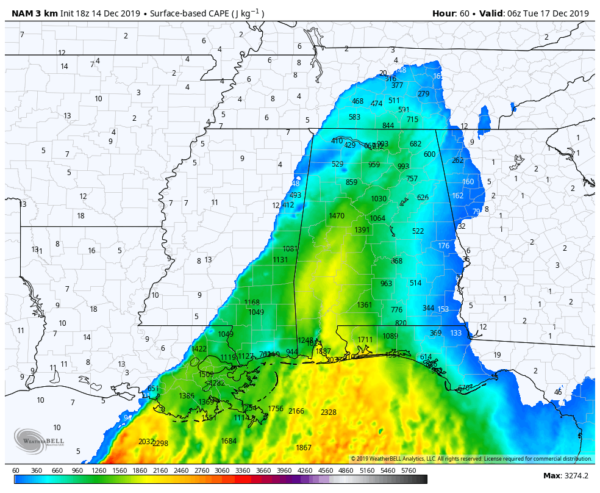
At the midnight hours, we do see that there is the potential for a good amount of instability to have moved into Central Alabama. We call this CAPE or Surface-Based Available Potential Energy. While these values are nowhere near the values that we could see during our Spring Severe Weather Season, these numbers are well more than enough to support strong to severe storms. This image shows values in the 500-1500 J/kg range with possible higher amounts in the southwestern parts of the area.
0-6 KM WIND SHEAR
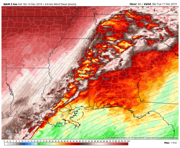
This is used to measure the expected amount of the change in wind from the surface up to six kilometers in the troposphere. Thunderstorms tend to become more organized and persistent as shear increases, and supercells are commonly associated with values of 35-40 knots or greater. We are seeing values reaching as high as 64 knots along and just south of the I-59/20 and I-20 corridors… well more than enough to support supercells and the extension of the life cycle of thunderstorms.
0-3 KM STORM RELATIVE HELICITY
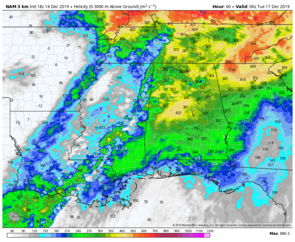
This is used to measure the potential for cyclonic updraft rotation in supercellular storms from the surface up to three kilometers in the troposphere. Values of 250 m2s2 or greater suggest an increased threat of tornadoes within supercellular thunderstorms. This image is showing us values as high as 450 m2s2.
SIGNIFICANT TORNADO PARAMETER (STP)
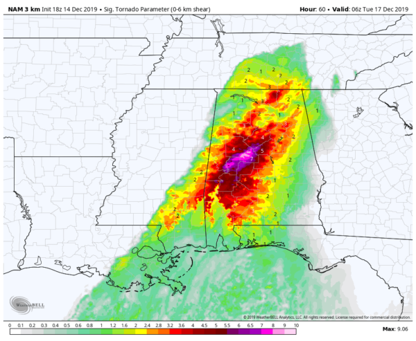
The Significant Tornado Parameter also referred to as the STP, takes measurements from several readings within the model output (effective bulk wind difference, effective storm-relative helicity, 100 MB mean parcel CAPE, 100 MB mean level convective inhibition and 100 MB mean parcel lifting condensation level. A majority of significant tornadoes have been associated with values greater than one. The higher the value, the greater potential there is for a significant tornado. The bad news is that this run is showing values up to as high as 9.0 in the northwestern parts of Bibb County.
As I mentioned earlier, the high-resolution NAM usually comes in a little high with the values, but even reducing these values by a usual amount, the values are still very supportive for the potential of strong to severe storms.
I believe these graphics show is that we’ll have a more active day on Monday than what we have seen with the previous severe weather threats over the past couple of weeks. Now, I definitely do not think this will be an outbreak of April 27, 2011 magnitude, all it takes is for one tornado to come down your street to make it a major event.
Go ahead and have your safety kits prepared and your safe place ready to go just in case your location goes under a warning during the event on Monday night into Tuesday morning. Since this will be affecting some people while asleep, have a trusty way of getting an alert that will wake you up. Be sure to have fresh batteries in your flashlights and in your NOAA WeatherRadios.
More updates to come on Sunday. Stay tuned.
Category: Alabama's Weather, ALL POSTS, Severe Weather
About the Author (Author Profile)
Scott Martin is an operational meteorologist, professional graphic artist, musician, husband, and father. Not only is Scott a member of the National Weather Association, but he is also the Central Alabama Chapter of the NWA president. Scott is also the co-founder of Racecast Weather, which provides forecasts for many racing series across the USA. He also supplies forecasts for the BassMaster Elite Series events including the BassMaster Classic.Subscribe
If you enjoyed this article, subscribe to receive more just like it.


