

Some Light Rain Tonight; Severe Storms Possible Saturday
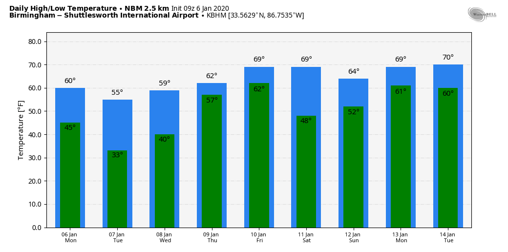
QUIET THROUGH MID-WEEK: We will forecast a mix of sun and clouds across Alabama today; temperatures will warm nicely, and most places will see a high in the low 60s this afternoon. Clouds thicken tonight, and some light rain is possible after midnight as a disturbance in the upper atmosphere passes through the region. Moisture is very limited, and rain amounts should under a tenth of an inch for most communities where rain falls.
The sky become sunny tomorrow as the wave passes on to the east; the high will be in the mid 50s. Wednesday will be another sunny day; the morning low will be around the freezing mark, followed by a high in the low 60s. Thursday will stay dry… with a partly sunny sky temperatures rise into the mid to upper 60s.
FRIDAY: Moisture levels rise, and we expect periods of rain during the day as a storm system approaches. Friday will be very mild for January with a high between 66 and 72 degrees. To the west, severe storms are likely across parts of East Texas, Louisiana, and Arkansas.
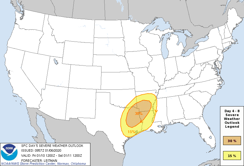
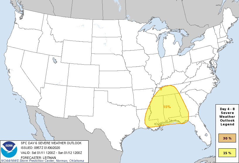
SEVERE STORMS POSSIBLE SATURDAY: SPC has defined a severe weather risk for all of Alabama and Mississippi on their “Day 6” outlook for Saturday.
A deep, negative tilt upper trough will interact with a warm, unstable airmass in place across the Deep South Saturday for occasional showers and thunderstorms; no doubt some of the storms could be strong to severe with potential for damaging wind and a few tornadoes. It is important to note that it is impossible to determine the magnitude of the event, and the specific timing six days in advance. Yes, there are strong signals that severe storms will form across our region based on the large, synoptic scale weather pattern. But, the small scale (mesoscale) features usually determine the true impact, and we simply don’t know how those elements will line up now.
So, no need to be anxious, just understand that severe storms are possible Saturday, and have a way of hearing warnings and a plan. We will be much more specific later this week as we get closer to the event.
We should also note that rain amounts Friday and Saturday will be in the 2-3 inch range over the northern half of the state, with 1-2 inches for South Alabama. With the ground pretty saturated, this could lead to some flash flooding issues.
SUNDAY AND NEXT WEEK: Dry air returns to Alabama Sunday with sunshine in full supply; the high will be in the low 60s. The next wave will bring some rain mostly to South Alabama early in the week, and no sign of any really cold, Arctic air for the next 7-10 days for Alabama. See the Weather Xtreme video for maps, graphics, and more details.
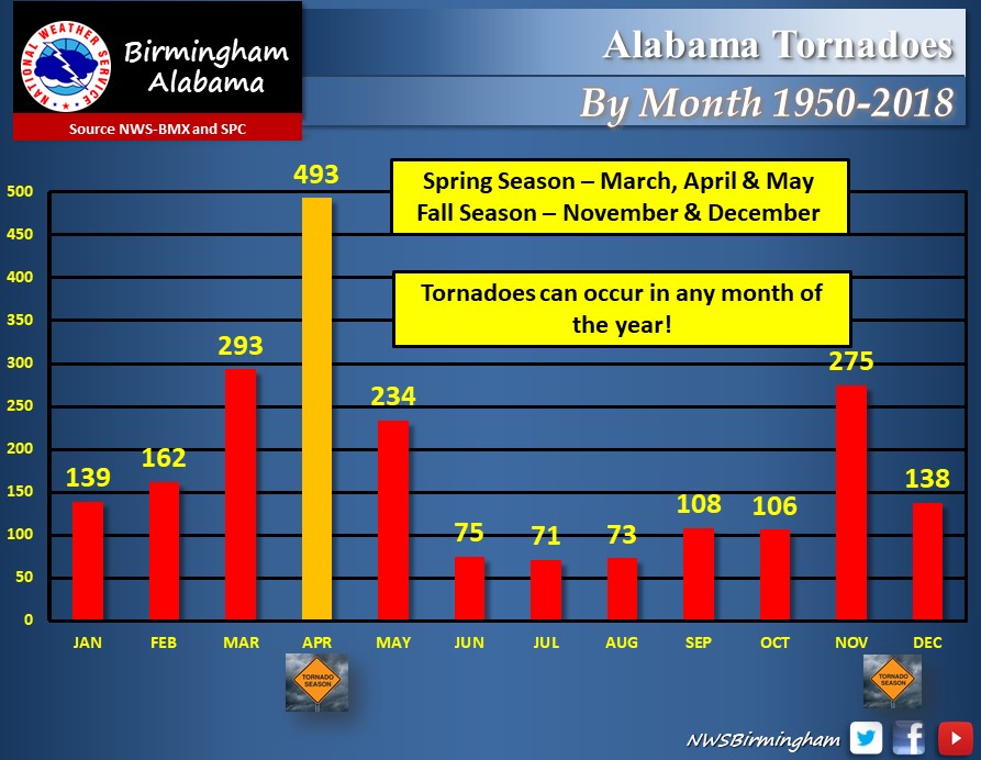
JANAURY SEVERE WEATHER? Alabama has experienced 139 tornadoes in January from 1950 through 2018… so having severe storms this time of the year is not all that unusual here.
ON THIS DATE IN 1996: The Great Blizzard was a severe nor’easter that paralyzed the East Coast on January 6 to the 8th. In Washington D.C., this storm is also known as the “Great Furlough Storm” because it occurred during the 1996 federal government shutdown. Snowfall amounts from this event includes: 47 inches in Big Meadows, Virginia; 30.7″ in Philadelphia; 27.8″ in Newark; 24.6″ at the Dulles International Airport; 24.2″ in Trenton; 24″ in Providence; 22.5″ in Baltimore; 18.2″ in Boston; 17.1″ in D.C.; and 9.6″ in Pittsburgh.
BEACH FORECAST: Click here to see the AlabamaWx Beach Forecast Center page.
WEATHER BRAINS: Don’t forget you can listen to our weekly 90 minute show anytime on your favorite podcast app. This is the show all about weather featuring many familiar voices, including our meteorologists here at ABC 33/40.
CONNECT: You can find me on all of the major social networks…
Facebook
Twitter
Instagram
Pinterest
Snapchat: spannwx
I have a weather program this morning at the Alabaster Public Library… look for the next Weather Xtreme video here by 4:00 this afternoon. Enjoy the day!
Category: Alabama's Weather, ALL POSTS, Weather Xtreme Videos
About the Author (Author Profile)
James Spann is one of the most recognized and trusted television meteorologists in the industry. He holds the AMS CCM designation and television seals from the AMS and NWA. He is a past winner of the Broadcast Meteorologist of the Year from both professional organizations.Subscribe
If you enjoyed this article, subscribe to receive more just like it.


