

Rain Returns Friday; Severe Storms Possible Saturday
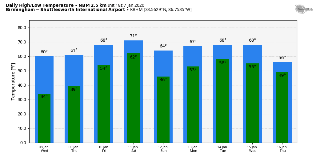
COBALT BLUE SKY: A very dry airmass covers Alabama this afternoon; the sky is sunny statewide. Temperatures are in the 50s over North Alabama, with 60s over the southern part of the state. Tonight will be clear and cold; we project lows between 28 and 34 degrees. Then, sunny weather continues tomorrow with a high in the low 60s. For Thursday, we rise into the mid 60s with a mix of sun and clouds.
FRIDAY: A deep layer of moist air moves into Alabama from the Gulf, and we expect periods of rain on Friday, with potential for a few thunderstorms as well. Temperatures will be very mild for January; we project a high in the 70-75 degree range. To the west, severe storms will likely develop across parts of East Texas, East Oklahoma, Arkansas, and Louisiana. Higher severe weather probabilities from SPC are centered around the ArkLaTex region.
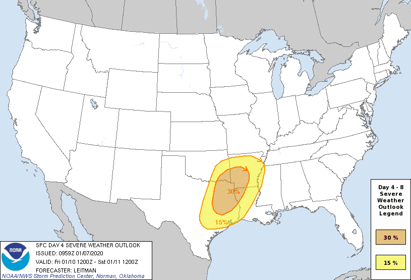
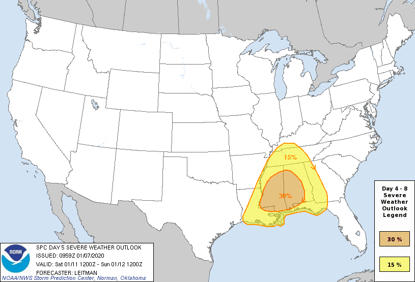
SEVERE WEATHER POTENTIAL IN ALABAMA SATURDAY: All of Alabama has a risk of strong to severe thunderstorms Saturday as a dynamic weather system interacts with a moist, unstable airmass. SPC has the higher severe weather probabilities over West and South Alabama, but know this outlook will change as we get closer to the weekend.
Some notes on the Saturday threat:
*These longer range outlooks from the Storm Prediction Center are not intended to create anxiety or worry. They are simply designed to inform you that severe storms are a possibility, and give you time to get ready.
*While the larger scale weather features certainly favor severe weather, the smaller, mesoscale features are yet to be determined. Therefore, it’s impossible to give you specific timing on the event right now, and placement of the highest severe weather threat. We can do that once we get within about 60 hours of the event.??
*Everyone will need a good, reliable way of getting severe weather warnings Saturday if they are needed.? Be sure WEA (“emergency alerts”) are enabled on your phone, and download the free ABC 33/40 weather app as well. Have a NOAA Weather Radio in your ?home and business. Never rely on an outdoor siren.
*Identify the safe place in your home… In a site built home, it is a small room on the lowest floor, near the center of the home, and away from windows.? Be sure everybody in the family knows where that safe place is, and in that room you need helmets for everyone in your family.? We also recommend having a portable air horn for everyone, as well as hard soled shoes.?
*If you live in a mobile home, you cannot stay there if you are in a tornado warning polygon.? Know the location of the nearest shelter or site built structure that is available.?? Those of us in the weather enterprise are working on the concept of an intermediate product between a watch and a warning… we know this is needed for mobile home residents to give you the necessary amount of time to get to a shelter.
*A tornado threat in January? This is nothing new… Alabama has experienced 139 tornadoes during the month of January since 1950. Tornadoes can happen during any month in our state, but the most active period is between November and May.???
*It is also important to note that heavy rain is likely Friday and Saturday… Rain amounts between 3 and 6 inches are likely for the northern half of the state, and flooding is a very real possibility.??
And, of course, keep an eye on forecast updates here as the weekend gets closer. Dry air returns Sunday; with a partly sunny sky we will still see highs in the 60s.
NEXT WEEK: A northward moving warm front will bring more rain to the state Monday, and it looks like we will need to hold on to some risk of rain Tuesday, especially during the morning. And, rain and storms are possible Wednesday as a cold front approaches; too early to know if this will bring a threat of severe storms. See the Weather Xtreme video for maps, graphics, and more details.
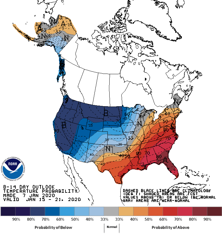
Still no sign of any Arctic air for the eastern or southern U.S… the latest CPC outlook issued today for the period January 15-21 shows very cold air for the northern and western U.S…. but above average temperatures around here.
ON THIS DATE IN 1989: An F4 tornado leveled a good portion of the town of Allendale, Illnois and injured 55 of its residents. The tornado directly impacted Allendale’s school, destroying the grade school portion, built in the 1960s. The high school portion, built in the late 1920s, withstood the storm with minimal damage.
BEACH FORECAST: Click here to see the AlabamaWx Beach Forecast Center page.
WEATHER BRAINS: Don’t forget you can listen to our weekly 90 minute show anytime on your favorite podcast app. This is the show all about weather featuring many familiar voices, including our meteorologists here at ABC 33/40.
CONNECT: You can find me on all of the major social networks…
Facebook
Twitter
Instagram
Pinterest
Snapchat: spannwx
I had a great time today visiting with students at Wilson School in Florence… be looking for them on the Pepsi KIDCAM today at 5:00 on ABC 33/40 News! The next Weather Xtreme video will be posted here by 7:00 a.m. tomorrow…
Category: Alabama's Weather, ALL POSTS, Weather Xtreme Videos
About the Author (Author Profile)
James Spann is one of the most recognized and trusted television meteorologists in the industry. He holds the AMS CCM designation and television seals from the AMS and NWA. He is a past winner of the Broadcast Meteorologist of the Year from both professional organizations.Subscribe
If you enjoyed this article, subscribe to receive more just like it.


