

Updated Look At Tomorrow’s Severe Weather Threat
There is little change in the thinking about tomorrow; we have a fairly significant threat of severe thunderstorms across all of Alabama. SPC, in their late mooring update, expanded the “moderate risk” (level 3/5) to include most all of Alabama.
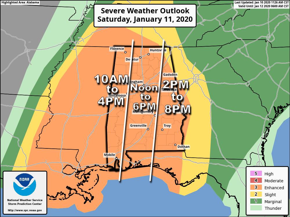
A reminder, don’t get too worried about the risk categories, colors, or lines on these maps; just know all of Alabama has a risk of severe thunderstorms.
THE SYSTEM: The most impressive part of the incoming storm system is the wind field; new model data continues to show a low level jet (5,000 feet off the ground) of 60-85 knots over much of the state (70-100 mph), and it won’t take much to get some of that down to the surface with the line of storms. This also leads to high SRH (Storm Relative Helicity) values, or veering of the wind with altitude in relation to storm motion. This will lead to potential to rotating updrafts, and a few tornadoes. There is a moderate amount of instability; models are probably underestimating the potential instability as surface temperatures should reach the 70s tomorrow afternoon before the storms arrive.
TIMING: The window for severe storms will open up in far West Alabama around 10:00 a.m. The line of severe storms will roll across the state during the afternoon hours; the threat in East Alabama should wind down around 7:00 to 8:00 p.m. This will be a mainly daytime event.
THREATS: The main threat tomorrow will come from damaging winds along the line of storms. Based on the forecast wind profiles, the damage potential could be fairly widespread. Also, a few tornadoes are possible in the line, and with any discrete storms that form ahead of the line. A strong tornado or two (EF-2 or higher) can’t be ruled out. The risk of hail is lower, but it is possible.
IMPORTANT WARNING NOTE: Pay close attention to severe thunderstorm warnings tomorrow. Straight line winds will be capable of producing tornado-like damage as the line of storms passes through. In fact, on a day like tomorrow I would go through your tornado plan if you are in a severe thunderstorm warning polygon. I would also not recommend being in a mobile home as these storms pass through; seriously consider going to your place of shelter well before the line of storms arrives. The winds tomorrow with the storms can knock down hundreds of trees across the state, and can also make a mobile home roll or flip.
GRADIENT WIND: A strong pressure gradient will set up tomorrow, and southerly surface winds (not related to thunderstorms) will average 15-30 mph, with occasional gusts to 40 mph possible. Be sure and secure loose objects on your property that might go airborne. A wind advisory is in effect.
RAIN: Rain amounts of 1 to 2 inches are likely tomorrow, but the storms will be moving quickly, and for now we aren’t expecting widespread flooding issues. Some localized problems are certainly possible, however.
STORM ANXIETY: In the weather enterprise, we walk a very fine line between honestly describing the magnitude of a severe weather threat, and creating storm anxiety. Just remember, if you have a good way of getting warnings and have a good plan, you will be safe and we will get through the day together. You won’t be alone.
GET THE WARNING: Be sure WEA (Wireless Emergency Alerts) are enabled on your phone, and get the free ABC 33/40 Weather app as well. The app enables you to choose the warnings you receive, and is polygon based. Every Alabama home and business needs a NOAA Weather Radio as a second tier; that system is not tied to any cell network. Never, never rely on an outdoor siren. They are designed to reach only a limited number of people outdoors.
KNOW YOUR SAFE PLACE: In a site built home, it is a small room, on the lowest floor, preferably near the center of the house, and away from windows. You do not have to be underground. For those that live in a trailer, you can’t stay there. Identify the nearest safe place (community shelter, business, etc), and know how to get there quickly. Never be in a vehicle.
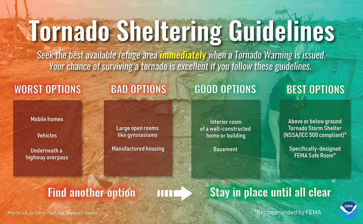
HAVE A READINESS KIT: In your safe place, have helmets for everyone, including adults. We also recommend portable air horns (if you need help), and hard sole shoes (if you have to walk across a tornado debris field to get help).
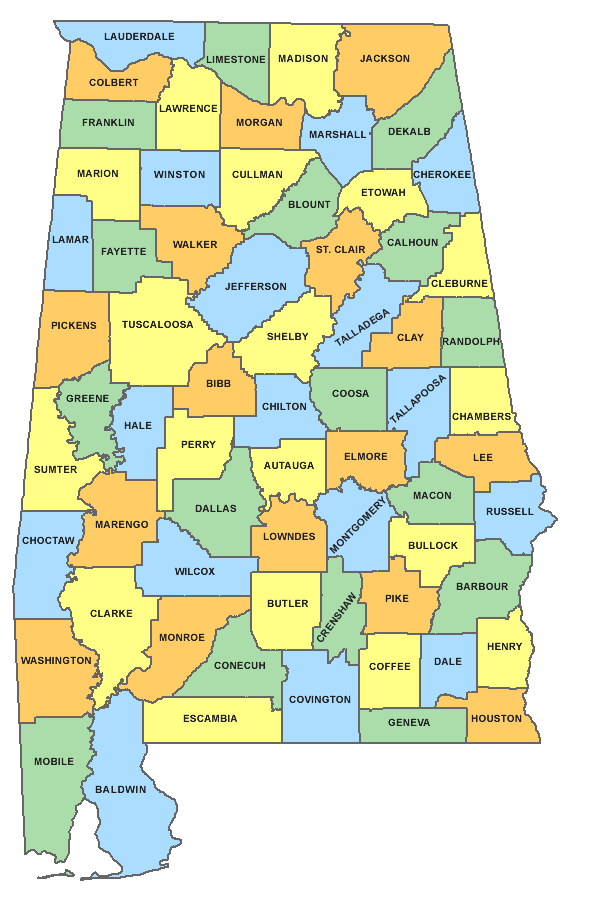
KNOW HOW TO FIND YOUR HOUSE ON A MAP: We don’t have much choice; we have to use maps before and during severe weather events. Know how to find your house on a map. Identify the county where you live, and know the counties near you. During the actual event itself, I am wall to wall on TV and can’t do individual briefings for those geographically challenged. This is a very important skill to learn.
WHY ARE WE HAVING A TORNADO THREAT IN JANUARY? Because in Dixie Alley, it happens. We have experienced 139 tornadoes during the month of January since 1950. In fact, on this date in 1975 a tornado moved through Pell City and Ragland in St. Clair County, killing one person and injuring many more. More recently, some recall the January 23, 2012 tornadoes; two were killed in Jefferson County county.
Keep an eye on the blog for updates as we get closer to the event!
Category: Alabama's Weather, ALL POSTS, Severe Weather
About the Author (Author Profile)
James Spann is one of the most recognized and trusted television meteorologists in the industry. He holds the AMS CCM designation and television seals from the AMS and NWA. He is a past winner of the Broadcast Meteorologist of the Year from both professional organizations.Subscribe
If you enjoyed this article, subscribe to receive more just like it.


