

An Evening Update On Saturday’s Threat For Severe Storms; List Of Open Storm Shelters
Latest Check On Severe Threat At 6:30 pm
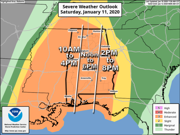
Nothing has really changed with our thinking for the threat of severe storms across North/Central Alabama at this time. The Storm Prediction Center continues an Enhanced Risk for severe storms (level 3 of 5) throughout the day on Saturday. Damaging winds exceeding 70 MPH and tornadoes (some could be strong) will be possible. Timing continues to be from 10:00 am to 8:00 pm for the threat of severe storms across the area. The above graphic shows a breakdown by sections of the area.
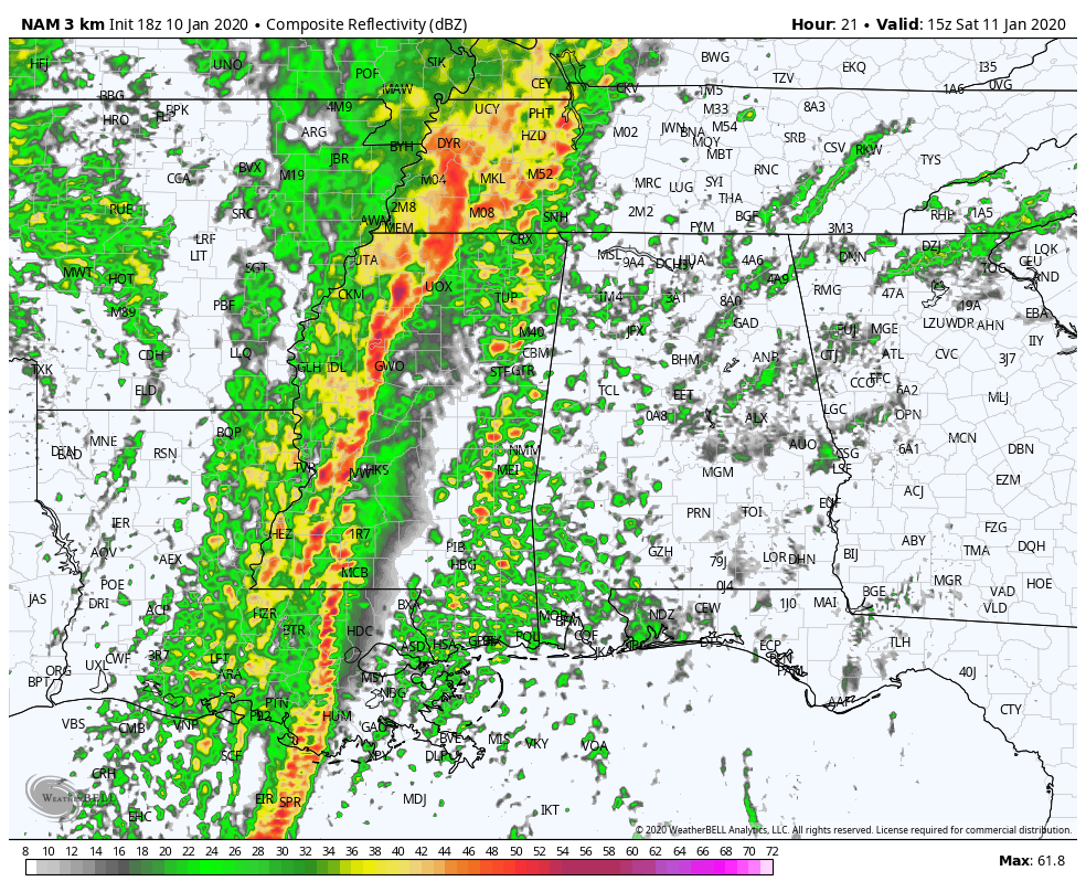
The above NAM 3k simulated radar animation is valid from 9:00 am to 9:00 pm Saturday. This shows that the main squall line will enter the western parts of the state around 11 am-1 pm, make it to the I-65 corridor around 2 pm-4 pm, and exiting the state by 7 pm-9 pm. This line will contain the threat of damaging winds up to and exceeding 70 MPH and a few tornadoes. The storms that can form out ahead of the line could become supercells and this is where the main threat of tornadoes will occur with the possibility that one or two could become strong long-track tornadoes (EF2 or greater).
Before the storms even make it to your area, gradient winds out ahead of the action will be strong at times, possibly gusting as high as 40 MPH or greater. With the saturated soils already across North/Central Alabama, these could cause trees to fall and some power outages.
All of North/Central Alabama goes under a Wind Advisory starting at midnight tonight and will go until 9:00 pm Saturday night.
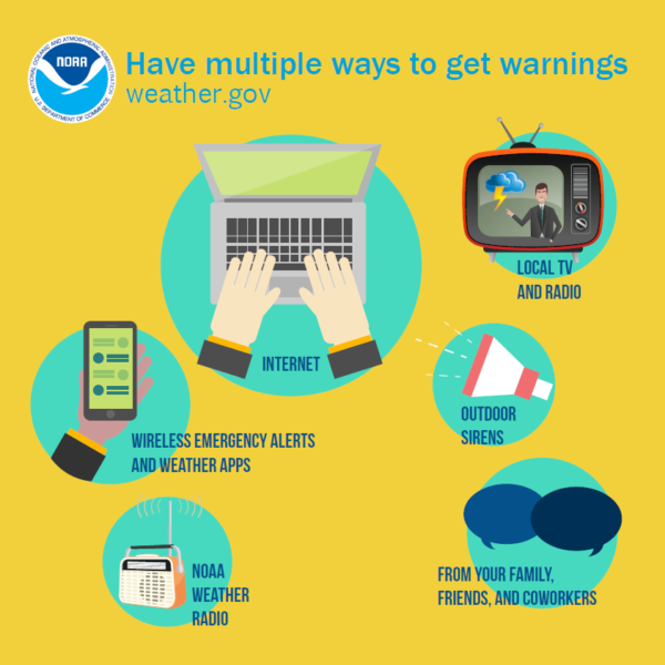
Have your emergency safety supplies kit ready tonight, along with your safety plan and your place of safety. Since we are expecting some power outages, be sure to have fresh batteries in your portable electronics and flashlights, and be sure to keep those phones charged. Have multiple ways to receive warnings throughout the day on Saturday.

With the threat of very strong winds with severe storms, please treat a severe thunderstorm warning just like a tornado warning. Get to your place of safety as winds of this nature can cause as much destruction like a tornado. As mentioned earlier, with the saturated soil, we can expect numerous trees to fall all across the state. Please BE PREPARED and STAY WEATHER AWARE.
Storm Shelters That Will Be Open
Blount County
Blountsville – Lee St., Adjacent to Town Hall
Cleveland – Park Rd., Cleveland Park
Hayden – 825 County Hwy 7, Next to West Blount Fire Dept.
Locust Fork – Town Hall Rd., Next to Locust Fork Fire Dept.
Snead – McCall St., Behind the Piggly Wiggly
Susan Moore – 4300 Susan Moore Rd., Susan Moore Ball Park
Calhoun County
First Baptist Church of Williams – 5579 County Road 37, Jacksonville
Piedmont High School
Ohatchee VFD
White Plains VFD
Webster’s Chapel VFD
Chilton County
West Chilton Fire Station #1 – 180 Howard St, Thorsby
Maplesville Shelter: Railroad Street adjacent to Maplesville Fire Station
Union Grove Fire State #1 – 10896 Co Rd 51, Jemison
Clanton City Hall – 505 2nd Ave N, Clanton
East Chilton Fire Station #1 – 5640 Co Rd 28, Clanton
Higgins Ferry Shelter: Higgins Ferry Campground area on Lake Mitchell
Enterprise Fire Station #1 – 3255 County Rd 49, Clanton
Verbena Fire Station #1 – 3885 HWY 31 S, Verbena
Cullman County
Town of Baileyton – 112 Fairview Road, Baileyton
Chapel Village Apts/Jones Chapel – 74 County Road 1034, Cullman
City of Hanceville – 202 Bangor Ave SE, Hanceville
City of Hanceville – 203 Michele St NW, Hanceville
City of Hanceville – 1407 Commercial St SE, Hanceville
City of Cullman – 1511 Sportsman Lake Rd, Cullman
City of Cullman – 500 2nd Ave SW, Cullman
Dodge City – 130 Howard Circle
Dodge City – 7150 County Road 223
Fairview Housing Authority – 96 Countryside Acres Rd, Cullman
Garden City Town Hall – 501 1st Ave SW, Garden City
Vinemont Providence VFD Station #1 – 576 Co Rd 1355, Vinemont
Vinemont Providence VFD Station #2 – 60 Ridgeway St, Cullman
City of Good Hope – 134 Town Hall Dr, Good Hope
City of Good Hope – 301 Day Gap Rd, Good Hope
CCCDD Beech Center – 1803 Beech Ave SE, Cullman
Town of West Point – 3990 Co Rd 1141, West Point
Gold Ridge VFD – 5225 Co Rd 1545, Cullman
Cherokee County
Centre First Baptist Church Basement – 300 E BYPASS, Centre, AL 35960
Cherokee County Courthouse Basement – 100 W Main St, Centre, AL 35960
FEMA Storm Shelter in Leesburg
Storm Shelter at Sand Rock (across from Sand Rock School)
Storm Shelter on Highway 411 North at New Bethel
Etowah County
Gallant Volunteer Fire Department – 9090 Gallant Road, Gallant
Bethlehem Missionary Baptist Church – 5850 Sardis Road, Boaz
Keener Baptist Church – US Hwy 11 & Keener Lane, Attalla
Black Creek Volunteer Fire Department – 20 Styles Bridge Road, Collinsville
Stowers Hill Baptist Church – 407 Ninth Ave. SW, Attalla
Etowah Baptist Association – 853 Walnut St. , Gadsden
Gadsden Public Library – 254 College Street, Gadsden
NE Etowah Community Center – 3733 US Hwy 411 N, Gadsden
Coates Bend – Macedonia Road Site – 2040 Macedonia Road, Gadsden
Paden Baptist Church – 900 Padenreich Ave, Gadsden
Goodyear Heights Baptist Church – 608 Kaying Road North, Gadsden
First Baptist Church Hokes Bluff – 5052 Main Street, Hokes Bluff
New Bethel First Congressional Methodist Church – 6673 Main Street, Hokes Bluff
Glencoe Community Shelter – 201 West Chastain Boulevard, Glencoe
Youngs Chapel Congregational Methodist Church – 44 Youngs Chapel Road, Piedmont
Southside Community Storm Shelter – 2255 Highway 77, Southside
First Baptist Church Southside – 2560 Mountain View Drive, Southside
Jefferson County
Adamsville – 421 Spring St, Adamsville
Bagley Fire Department – 7175 Bankhead Hwy. Dora
Birmingham: Jimmie Hudson Park – 305 Pratt Highway
Birmingham: Pratt City Park – 1331 3rd Street
Birmingham: Smithfield Estates – 1707-B Huntington Drive
Brookside – 2711 Municipal Lane
Concord – 6117 Willow Circle, Concord
Edgewater Oaks Subdivision – Lannie Bonner Circle, Birmingham
Fultondale – 3220 Hubbert Drive
Fultondale – Maple Crest Drive & Walker Chapel Road
Graysville – 4041 Cherry Avenue, Birmingham
North Smithfield – I4533 Hutson Avenue North, Birmingham
North Smithfield Manor – North Smithfield Manor Lane, Birmingham
Pleasant Grove – 464 7th Avenue
Tannehill State Park – 12632 Confederate Parkway, McCalla
Trussville – 421 Cherokee Drive
Vestavia Hills: Liberty Park Athletic 4700 Sicard Hollow Road
Warrior: Shelter I – 309 Trafford Road
Warrior: Shelter 2 – 140 Cane Creek Road
Marion County
Collins Life Center – 581 14th St North, Guin
911 21st Street, Haleyville
721 County Road 51, Haleyville
1206 10th Avenue, Haleyville
930 4th Avenue, Haleyville
2324 14th Avenue, Haleyville
More listings can be found on the List Of Storm Shelters Across Central Alabama page.
Category: Alabama's Weather, ALL POSTS, Severe Weather
About the Author (Author Profile)
Scott Martin is an operational meteorologist, professional graphic artist, musician, husband, and father. Not only is Scott a member of the National Weather Association, but he is also the Central Alabama Chapter of the NWA president. Scott is also the co-founder of Racecast Weather, which provides forecasts for many racing series across the USA. He also supplies forecasts for the BassMaster Elite Series events including the BassMaster Classic.Subscribe
If you enjoyed this article, subscribe to receive more just like it.


