

Enhanced Risk For Severe Storms For Much Of The Area Today
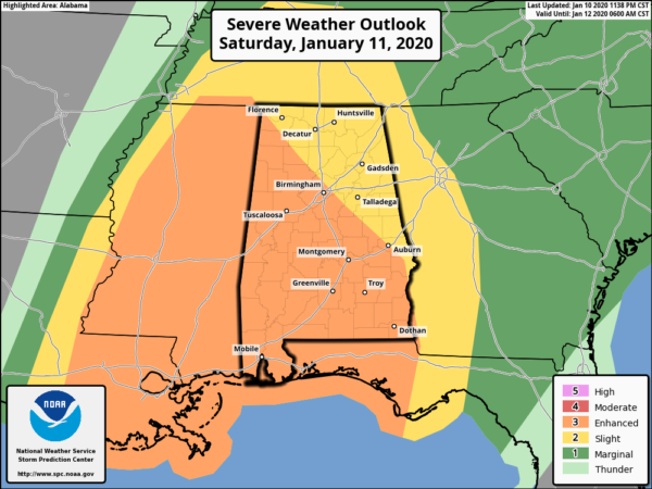
As of 3:00 am this morning, the Storm Prediction Center continues an Enhanced Risk over a portion of North Alabama and a good chunk of Central Alabama, roughly along and west of a line from Waterloo (Lauderdale Co.) to Harpersville (Shelby Co.) to Auburn (Lee Co.). A Slight Risk is up for the rest of North and Central Alabama.
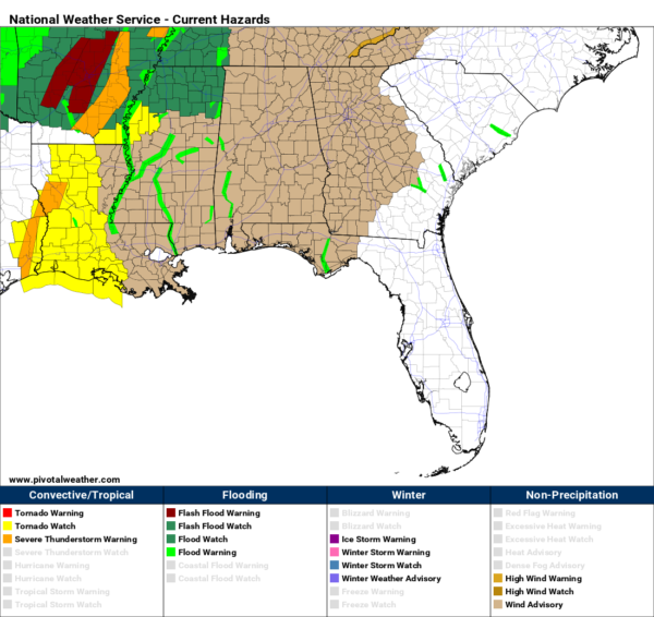
Wind Advisories are in effect for all of North and Central Alabama through 9:00 pm tonight. Winds will be sustained at 10-20 MPH throughout the day with gust up to 40 MPH, while higher elevations could see gusts up to 50 MPH. These winds will occur outside of any thunderstorm activity due to the tightening pressure gradient. With the saturated soil, weakened trees could be blown down which may result in a few power outages.
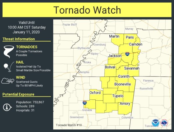
A Tornado watch has just been issued for northeastern Mississippi and west-central Tennessee until 10:00 am this morning.
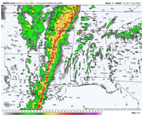
Let’s look at the 07z run of the HRRR and we see that the main line of strong to severe storms will be located in Central Mississippi at 9:00 am with some scattered showers over North/Central Alabama. This is when we would need to start watching for any cells that could develop out ahead of the main line as the ingredients will be there to support supercells along with a few tornadoes. As you can see, the HRRR is showing that instability will be increasing over the western half of the area, along with the Significant Tornado Parameter as values will be approaching 3.5 in some spots.
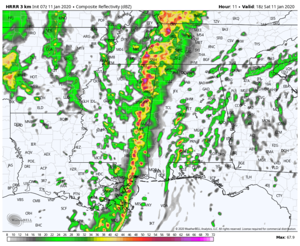
Around noon, the main line will begin to cross over the state line into the western parts of North/Central Alabama. This is where the main threat of damaging winds in excess of 70 MPH will be possible along with a few spin-up tornadoes. Out ahead of that, the risk of supercells will continue and this model run shows the possibility of those as far east as the I-65 corridor. Instability and STP values have really increased over the area, but I think the HRRR might be running a little too high with this. No matter what the models say, the potential for tornadoes and damaging winds continue.
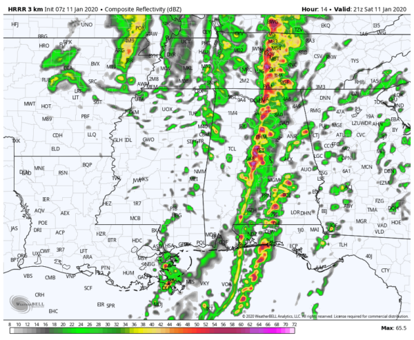
Around 3:00 pm, the main line of storms will be crossing the I-65 corridor in the central parts of North/Central Alabama while a few cells have formed out ahead of the line. Remember, this is just a model showing what radar may look like. Behind the line, instability will be virtually gone and the severe threat will be over for western parts of the area, while we continue to see increased instability along and east of the line. The same can be said of the STP values. Once again, I think the HRRR may be running a little too high on this run, but the potential continues.
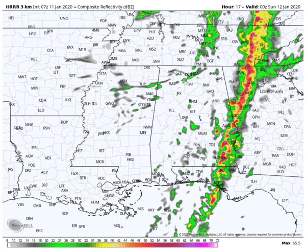
Around 6:00 pm, we see that the line is in the process of crossing over into Georgia with the threat of severe weather remaining for the extreme southeastern parts of Central Alabama. At this point, damaging winds and a brief tornado or two look to be the main threats as instability starts weakening along with a large decrease in STP values. The severe threat is over for all of the state by 7:00 pm on this model run.
While these model images may look a little scary, this is not meant to scare you. As long as you stay weather aware and take the appropriate action if your location goes under a warning, you should be in good shape. Don’t ride out a tornado warning if you live in a mobile or manufactured home. Please find a place now where you can safely ride out the storm… it can be a friend or relative’s house or a community storm shelter. Either way, you’ll be safer in a tornado warning there than in a mobile or manufactured home. There is a list of storm shelters that will be open today on the ABC 33/40 website.
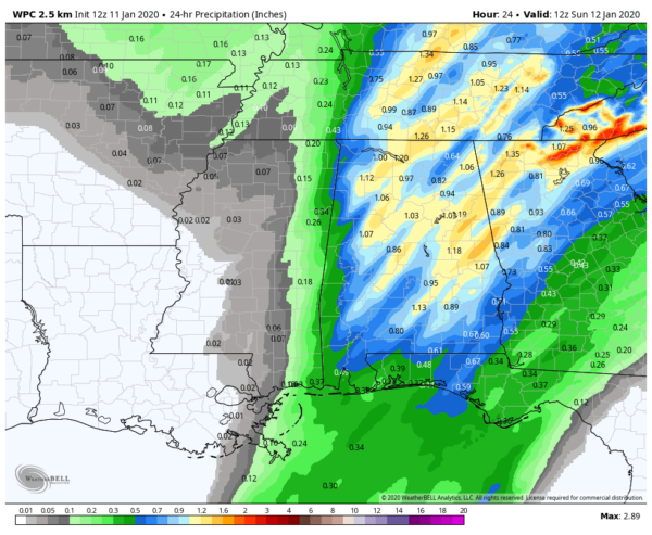
Projected rainfall from 6:00 am today through 6:00 am Sunday look to be around 1 inch to 1.25 inches across the area, but I wouldn’t be surprised if there are a few locally heavier amounts. Afternoon highs will top out in the lower to mid-70s across the area today.
Sunday will be a nice day across Central Alabama with skies becoming mostly sunny for a little while during the late morning and afternoon hours. Clouds will make a return from the south and rain chances will begin to increase during the evening and overnight hours. Highs will be in the lower 60s to the lower 70s.
We look to have some rain at times on Monday as the cold front that pushes through today will return northward through the area as a warm front. At this point, no severe weather is expected, but I wouldn’t be surprised if we have a few thunderstorms. Highs will be in the mid-60s to the lower 70s.
We will continue in an unsettled weather pattern on Tuesday with rain and a few thunderstorms likely at times. Skies will be cloudy when not raining and highs will be in the upper 60s to the mid-70s.
Much of the same story on Wednesday as rain will be likely at times, but a cold front will be approaching from the west that will finally help push this activity off to the east. Highs will be in the 70s throughout the area.
By Thursday, the cold front will have moved through the area and it looks like we’ll finally get a chance to dry out. Rain looks to come to an end before sunrise, but skies will remain mostly cloudy. Highs will be in the upper 50s to the lower 70s from northwest to southeast.
Friday looks to be a dry and decent day across Central Alabama, but we’ll still have to deal with mostly cloudy skies. Highs will reach the upper 50s to the upper 60s.
That will wrap it up for today’s Weather Xtreme Video. Bill Murray and myself will be with you throughout the day with updates along with any watches and warning that may be issued. Bill will have the next video out on Sunday morning. I’m Scott Martin, signing off for today. Be prepared and stay weather aware… and God bless.
Category: Alabama's Weather, ALL POSTS, Severe Weather, Weather Xtreme Videos
About the Author (Author Profile)
Scott Martin is an operational meteorologist, professional graphic artist, musician, husband, and father. Not only is Scott a member of the National Weather Association, but he is also the Central Alabama Chapter of the NWA president. Scott is also the co-founder of Racecast Weather, which provides forecasts for many racing series across the USA. He also supplies forecasts for the BassMaster Elite Series events including the BassMaster Classic.Subscribe
If you enjoyed this article, subscribe to receive more just like it.


