

Nice Warm-Up Today; Some Light Rain Tomorrow
COLD START: A few spots across North Alabama are below freezing this morning… here are some of the colder temperatures just before daybreak….
Pell City 30
Gadsden 31
Haleyville 31
Weaver 31
Black Creek 31
Sylacauga 32
Alexander City 33
Fort Payne 34
Cullman 34
Jemison 36
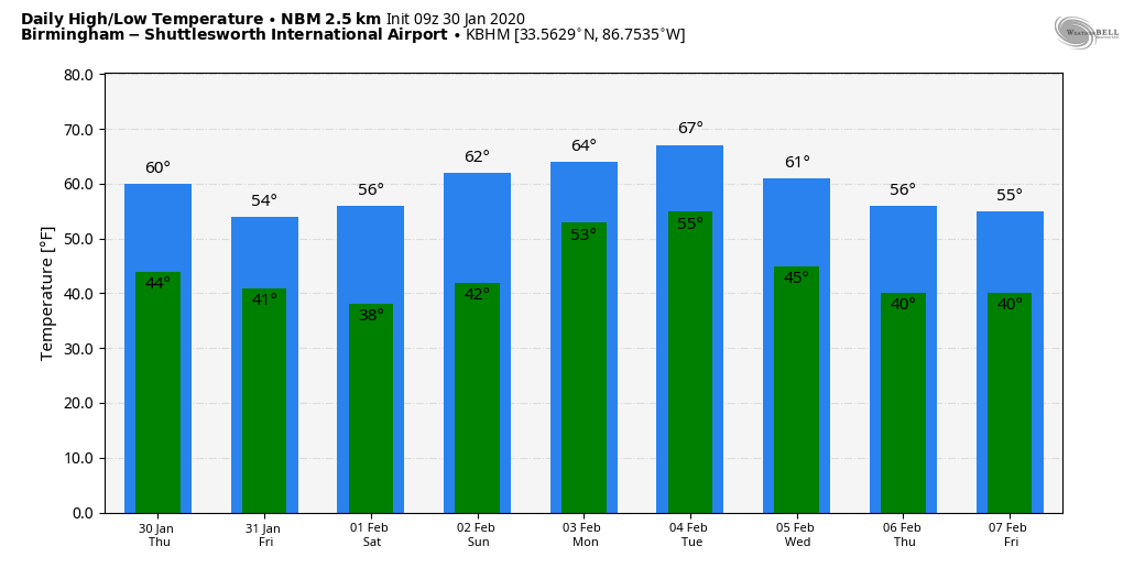
Despite the morning chill, we expect a nice warm-up across Alabama today; the high will be close to 60 over the northern counties, with mid 60s for the southern counties. The sky will be partly to mostly sunny… then clouds increase tonight ahead of the next wave approaching from the west.
TOMORROW AND THE WEEKEND: Tomorrow will be a cloudy day with few periods of light rain likely. Amounts should be under 1/4 inch for the northern half of Alabama, with around 1/2 inch to the south. It will be a cool day with a high in the low 50s… some communities in North Alabama could hold in the 40s all day.
Then, on Saturday, we expect more clouds than sun, and an upper trough could squeeze out a few isolated showers. Nothing widespread, and many places won’t see a drop. Then, on Sunday, the sky will be mostly sunny as a nice punch of dry air works into the state. The high Saturday will be in the mid to upper 50s, and then we expect low 60s Sunday afternoon.
NEXT WEEK: Monday will be dry and mild with a high in the mid 60s. Clouds increase late in the day, and a few showers could reach Alabama Monday night. Then, on Tuesday, temperatures will rise into the 65-70 degree range ahead of a disturbance that will bring showers and thunderstorms to the state. A few strong storms will be possible by the afternoon and evening hours Tuesday, but for now the lack of instability looks to keep the severe weather threat fairly low.
An upper trough will hang back to the west, and clouds will likely linger Wednesday and Thursday, but the best chance of rain on those two days will be over the southern quarter of the state near a stalled surface front. The high will be close to 50 over North Alabama as colder air returns. Friday looks dry with ample sunshine along with a high in the 50s. See the Weather Xtreme video for maps, graphics, and more details.
ON THIS DATE IN 1966: Bitterly cold air covered Alabama, and the state had the coldest temperature in the lower 48 states that day. It was reported nationwide that Russellville, at -24F, was the coldest spot in the nation. A U.S. Army officer serving in Vietnam remembers hearing the news that day that his hometown of Russellville earned the coldest-spot honors.
That distinction was not to last, however. Years later a Birmingham reporter was digging for a news story on Alabama’s coldest periods. This was back in the day when official reports were all on paper, often buried in dusty archives. He discovered a mistake, leading the National Climatic Data Center to correct its records to show Alabama’s lowest temperature was actually -27F set at New Market on Jan 30, 1966. The observation was recorded by Lucille Hereford, postmistress and town volunteer weather observer in New Market. To this day it is the coldest temperature on record in the state.
ALSO ON THIS DATE IN 1966: The Blizzard of 1966 temporarily isolated Buffalo, New York and paralyzed the region. Train service was disrupted. Numerous highways, the New York State Thruway from Albany to the Pennsylvania state line, and the Buffalo Airport as well as other airports throughout western and central New York were closed. Hardest hit was the Syracuse-Oswego area. 100 inches of snow was reported at Oswego, NY. Some schools in Orleans County were closed for the entire week following the blizzard. Economic loss from the storm was estimated at $35 million dollars.
STORM SPOTTER TRAINING: Our annual storm spotter training is Saturday, February 8 at the Hoover Met. It begins at 9:30; and there is no cost. We will offer both the basic and advanced training sessions… we expect to wrap up by 2:30. No need to register; just show up with a curious mind. We need more trained storm spotters! Help us make the warning process better!
BEACH FORECAST: Click here to see the AlabamaWx Beach Forecast Center page.
WEATHER BRAINS: Don’t forget you can listen to our weekly 90 minute show anytime on your favorite podcast app. This is the show all about weather featuring many familiar voices, including our meteorologists here at ABC 33/40.
CONNECT: You can find me on all of the major social networks…
Facebook
Twitter
Instagram
Pinterest
Snapchat: spannwx
I have weather programs today at Ashland Elementary in Clay County, and also Eden Elementary in Pell City… look for the next Weather Xtreme video here by 4:00 this afternoon. Enjoy the day!
Category: Alabama's Weather, ALL POSTS, Weather Xtreme Videos
About the Author (Author Profile)
James Spann is one of the most recognized and trusted television meteorologists in the industry. He holds the AMS CCM designation and television seals from the AMS and NWA. He is a past winner of the Broadcast Meteorologist of the Year from both professional organizations.Subscribe
If you enjoyed this article, subscribe to receive more just like it.


