

Soaking Rains Continue; Falling Temperatures Today
**No Weather Xtreme video this morning**
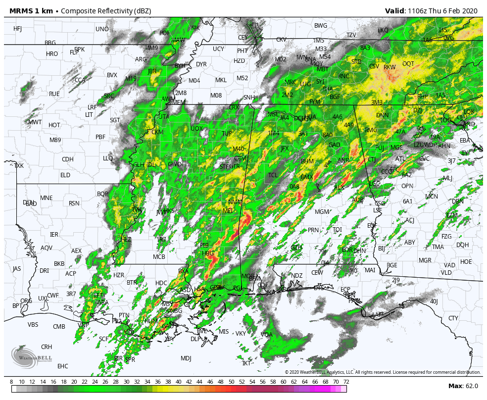
RADAR CHECK: Rain and thunderstorms cover most of Alabama this morning as a long wave upper trough and cold front move in from the west.
Here are the current watches and warnings as of daybreak…
*Flash flood watch remains in effect for most of the state through this evening.
*A flash flood warning is in effect for the southern part of the Birmingham metro; it will expire at 6:30
*A tornado watch is in effect for parts of East and South Alabama until 12:00 noon.

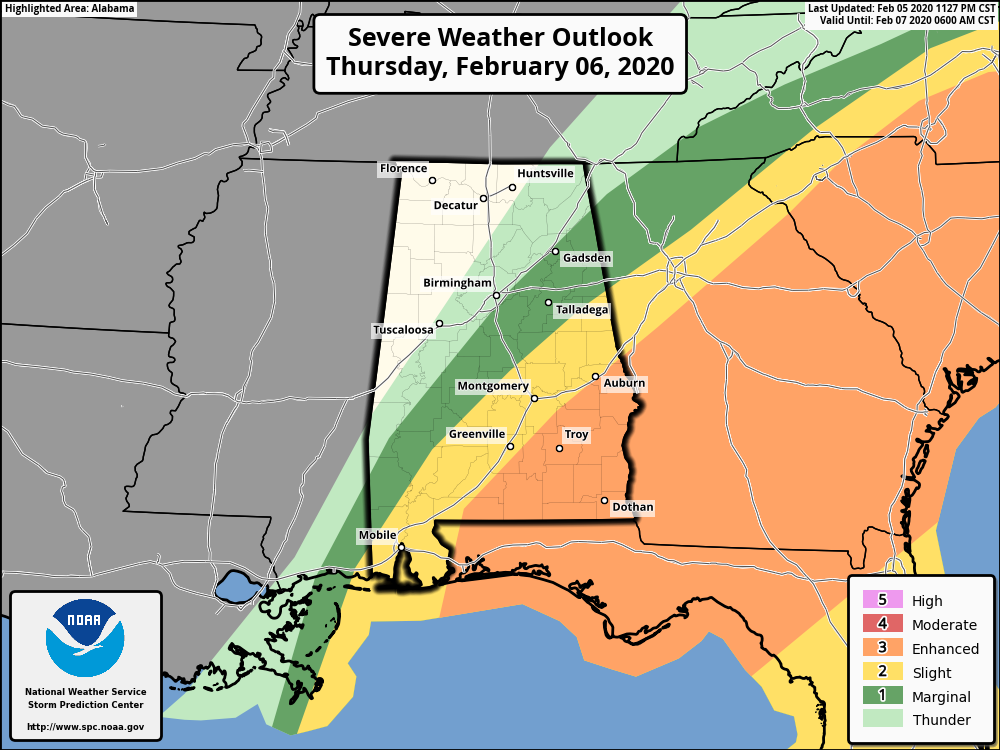
*SPC has continues an “enhanced risk” (level 3/5) of severe thunderstorms today for the southeast part of the state… storms there will be capable of producing hail, damaging winds, and a few tornadoes.
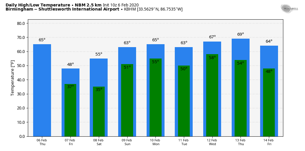
Rain will continue today across all of Alabama, but it will taper off this afternoon from northwest to southeast. Temperatures will go the wrong way; many places are in the 60s early this morning, but they will fall through the 50s today, winding up in the 40s by mid to late afternoon. It will be quite the change from the recent warmth. Additional rain amounts of 1-2 inches are forecast today.
SNOW FLAKES? High resolution models show just enough moisture left late tonight and tomorrow morning for a few snow flurries or showers across the northern third of Alabama. We expect no impact with temperatures in the mid 30s, and very light precipitation amounts. Then, we expect clearing during the day Frida with a high in the 47-50 degree range.
THE ALABAMA WEEKEND: A fast moving weather disturbance will bring clouds, and maybe a touch of scattered light rain to the state Saturday, but moisture will be very limited, and rain amounts will be light. Saturday’s high will be in the mid 50s. Then, on Sunday, with ample sunshine temperatures rise into the low to mid 60s.
NEXT WEEK: Moist air returns quickly to the state and we will have a chance of rain at times just about every day next week with highs in the 60s. The coldest air in the nation will remain out over the western states.
PRE-DAWN TORNADO WARNINGS: A few short lived tornadoes developed across Central Alabama after midnight and early this morning. There was some damage at Helena, in Shelby County, but no reports of any injuries.
ON A PERSONAL NOTE: I don’t think I have been truly “sick” in 20 years… maybe a sinus infection along the way. But something grabbed me last night and I am down for the count this morning. Thanks to Taylor Sarallo and Meaghan Thomas for covering for me during severe weather coverage on ABC 33/40. I hated not to be there, I am in survival mode now. Will get a doctor today to get me on the road to recovery.
STORM SPOTTER TRAINING: Our annual storm spotter training is this Saturday, February 8 at the Hoover Met. It begins at 9:30; and there is no cost. We will offer both the basic and advanced training sessions… we expect to wrap up by 2:30. No need to register; just show up with a curious mind. We need more trained storm spotters! Help us make the warning process better!
BEACH FORECAST: Click here to see the AlabamaWx Beach Forecast Center page.
WEATHER BRAINS: Don’t forget you can listen to our weekly 90 minute show anytime on your favorite podcast app. This is the show all about weather featuring many familiar voices, including our meteorologists here at ABC 33/40.
CONNECT: You can find me on all of the major social networks…
Facebook
Twitter
Instagram
Pinterest
Snapchat: spannwx
If I can come back from my sick bed, I will have a new afternoon Weather Xtreme video here by 4:00 this afternoon. Enjoy the day and stay dry…
Category: Alabama's Weather, ALL POSTS
About the Author (Author Profile)
James Spann is one of the most recognized and trusted television meteorologists in the industry. He holds the AMS CCM designation and television seals from the AMS and NWA. He is a past winner of the Broadcast Meteorologist of the Year from both professional organizations.Subscribe
If you enjoyed this article, subscribe to receive more just like it.


