

Threat For Damaging Winds & A Brief Tornado Continue For North/Central Alabama
Plenty of reports of trees downed and damage are coming in from across the northwestern parts of the state, including a bard being destroyed in the Lexington community (Lauderdale Co.).
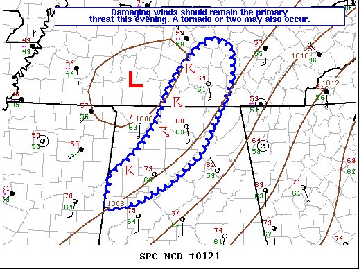
Here is the text from the latest Mesoscale Discussion from the Storm Prediction Center concerning the threat of severe weather for North/Central Alabama:
The severe weather threat for the Severe Thunderstorm Watch continues.
SUMMARY…Damaging winds should remain the primary threat this evening. A tornado or two may also occur.
DISCUSSION…A shallow convective line has consolidated early this evening along/just ahead of a cold front. Low-level flow across much of central/northern AL into middle TN remains quite strong per VWP estimates from KGWX and KHTX, with winds quickly increasing to 50-60 kt in the 0-1 km layer. The overall line is moving quickly northeastward around 45-55 kt, with individual elements embedded within the line moving even faster. Given the very strong flow present largely parallel to the surface front, a mainly linear mode should continue to dominate this evening. Damaging winds will likely remain the primary threat, with a few reports of trees and building
damage already noted. A tornado or two cannot be ruled out in the short term, mainly across northern AL where low-level winds have locally backed to south-southeasterly as a surface low develops and gradually deepens into middle TN. Instability will remain weak, but sufficient to support strong/gusty surface winds.
Category: Alabama's Weather, ALL POSTS, Severe Weather
About the Author (Author Profile)
Scott Martin is an operational meteorologist, professional graphic artist, musician, husband, and father. Not only is Scott a member of the National Weather Association, but he is also the Central Alabama Chapter of the NWA president. Scott is also the co-founder of Racecast Weather, which provides forecasts for many racing series across the USA. He also supplies forecasts for the BassMaster Elite Series events including the BassMaster Classic.Subscribe
If you enjoyed this article, subscribe to receive more just like it.


