

Dreary For Much Of The Rest Of Your Thursday; Sunshine Returns On Friday
CONDITIONS AS WE APPROACH MIDDAY
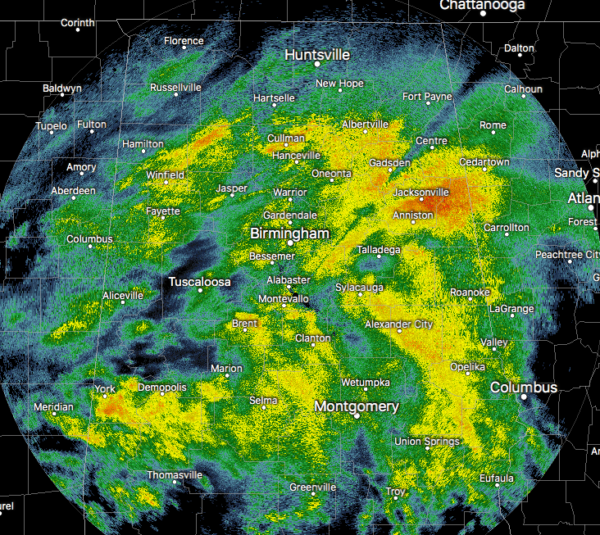
Radar continues to show a good bit of moderate to spots of heavy rainfall across much of Central Alabama, while several locations are getting some snow showers in the northern parts of the state north of the Tennessee River. So far, no major travel issues, but a few slick spots have been reported in Florence. Temperatures across the area were in the mid-30s in the north to the lower 50s in the south. Huntsville was the cold spot at 35 degrees while Selma and Montgomery were the warm spots at 52 degrees. Birmingham was at 45 degrees.
RAIN FOR MOST, SOME SNOW IN NORTH ALABAMA
For the rest of the morning and into the afternoon hours, rain will continue to be likely for all of Central Alabama, some of which could be heavy at times especially over the southern half of the area. A Flash Flood Watch continues until 6:00 pm this evening for much of the southern half of the area. The rain has turned to snow in the northern parts of North Alabama with accumulations mainly occurring on grassy and elevated locations. While a few slick spots are possible, major travel issues are not expected. Highs will top out in the lower 40s to the mid-50s from northwest to southeast in Central Alabama, and in the lower 40s in North Alabama (which has already occurred). Rain will end during the evening hours from northwest to southeast and colder air will settle into the area. Lows in North Alabama will be in the mid-20s and in the mid-20s to the upper 30s from northwest to southeast in Central Alabama.
SUNSHINE RETURNS FOR FRIDAY
Much of the area will see nearly-maximum sunshine with the exception of the southeastern corner, where a few lingering clouds will keep the skies partly cloudy for a bit. Afternoon highs will only make it into the mid-40s to the lower 50s across the area from northwest to southeast.
THE CENTRAL ALABAMA WEEKEND
Saturday will be a fantastic day, but it will be a touch cool as highs will top out in the mid to upper 50s. Sunday will start off with partly cloudy skies, but clouds will be on the increase and so will shower chances during the afternoon and evening hours. Rain will become likely during the late evening and through the overnight hours. Highs will be in the mid-50s to the lower 60s.
A WET START TO THE WORK WEEK
Monday looks to be a wet day across the area as rain will be likely. Highs will be in the 60s. We’ll get a brief reprieve from the rain on Tuesday as skies will be mostly sunny, but we’ll have a small chance of showers during the evening and through the day on Wednesday. Tuesday’s highs will be in the 60s then dropping back into the lower 50s to the mid-60s on Wednesday.
COULD BE A WET END TO THE WORK WEEK
As we step into Voodoo Land to end off the forecast, it looks like there will be a chance of rain on both Thursday and Friday. Highs look to be in the lower 40s to the mid-50s across the area on Thursday and in the lower 40s to the lower 50s on Friday.
2020 SEVERE WEATHER AWARENESS WEEK – 2/16-2/21
As you know, Alabama is no stranger to severe weather, especially tornadoes. They can happen at any time of the year and at any time, day or night. We are approaching our primary severe weather season for Alabama (March, April, and May). Our 2020 Severe Weather Awareness Week starts on Sunday, February 16th and goes through Friday, February 21st. We will have posts on the blog throughout the week discussing severe weather hazards and safety. Governor Ivey has also declared next weekend (Friday, February 21st through Sunday, February 23rd) as the 2020 Severe Weather Preparedness Sales Tax Holiday. For more information on the tax holiday, please CLICK HERE to visit the Alabama Sales Tax Holiday section of NWS Birmingham’s Severe Weather Awareness Week page.
NWS BIRMINGHAM SKYWARN STORM SPOTTER TRAINING
The National Weather Service office in Birmingham will be offering several online Basic Spotter Courses and a single Advanced Spotter Course over the next few months. These online courses are FREE and are open to anyone who would like to learn more about what it takes to be a spotter and what to look for. More information can be found on the NWS Birmingham’s website, just CLICK HERE to visit the site.
BEACH FORECAST
Get the latest weather and rip current forecasts for the beaches from Bay St. Louis, MS, to Panama City Beach, FL, on our Beach Forecast Center page. There, you can select the forecast of the region that you are interested in.
ADVERTISE WITH THE BLOG!
We had another fantastic year in 2019 with just over 17 million page views! That brings our total for the last 2 years close to 37 million page views! Don’t miss out! We can customize a creative, flexible, and affordable package that will suit your organization’s needs. Contact Bill Murray at (205) 687-0782.
E-FORECAST
Get the Alabama Wx Weather Blog’s Seven-Day Forecast delivered directly to your inbox by email twice daily. It is the most detailed weather forecast available in Central Alabama. Subscribe here… It’s free!
CONNECT WITH THE BLOG ON SOCIAL MEDIA
You can find the AlabamaWx Weather Blog on the major social media networks:
Facebook
Twitter
Instagram
WEATHERBRAINS
Don’t forget you can listen to our weekly 90 minute netcast anytime on the web at WeatherBrains.com or on Apple Podcasts, Stitcher, or Spotify. This is the show all about weather featuring many familiar voices, including the meteorologists at ABC 33/40.
Category: Alabama's Weather, ALL POSTS, Winter Weather
About the Author (Author Profile)
Scott Martin is an operational meteorologist, professional graphic artist, musician, husband, and father. Not only is Scott a member of the National Weather Association, but he is also the Central Alabama Chapter of the NWA president. Scott is also the co-founder of Racecast Weather, which provides forecasts for many racing series across the USA. He also supplies forecasts for the BassMaster Elite Series events including the BassMaster Classic.Subscribe
If you enjoyed this article, subscribe to receive more just like it.


