

Rain At Times Through Tonight; Dry Tomorrow
RADAR CHECK: Showers cover much of North and West Alabama this afternoon; we note a few thunderstorms over the Tennessee Valley, but they are well below severe limits. Still, SPC maintains a low end, “marginal risk” of severe thunderstorms for North Alabama through the evening hours. There could be a stronger storm with small hail and gusty winds, but the overall risk is very low as the main dynamic support is lifting far to the north of Alabama.
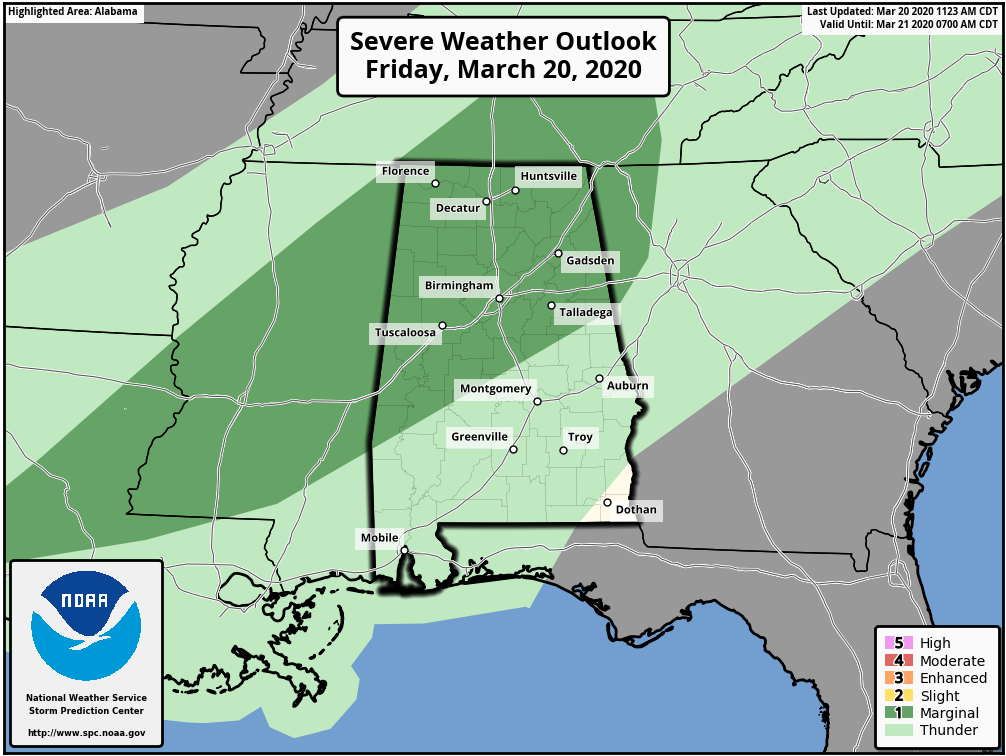
Rain amounts over the next 12 hours will be in the 1/2 to 1 inch for most of North/Central Alabama. Rain will end after midnight.
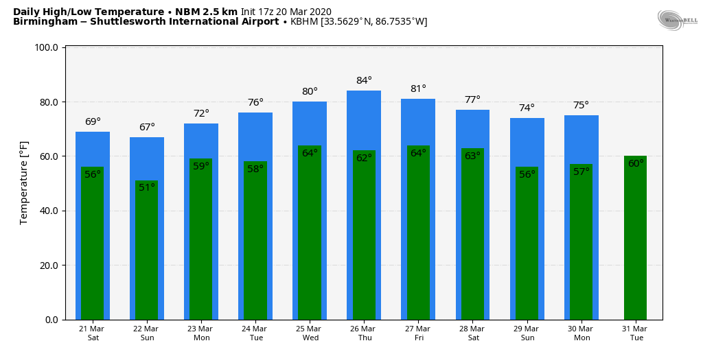
THE ALABAMA WEEKEND: Drier, cooler air will slip into North Alabama tomorrow; most of the state will be dry with just a few isolated showers for far South Alabama. The sky becomes partly sunny, and the high will be in the mid to upper 60s. Clouds will increase tomorrow night, and the surface boundary over the southern counties of the state will move northward as a warm front. Expect periods of rain Sunday with temperatures in the 60s. Rain amounts will be around 1/2 inch.
NEXT WEEK: We will maintain the chance of some rain at times Monday, and showers are possible Tuesday afternoon and Tuesday night as a compact disturbance passes north of the state. Then, the latter half of the week looks mostly dry and warm; we could approach record levels Thursday with highs in the mid to upper 80s. On the positive side, still no signs of any severe thunderstorm or flooding issues for Alabama over the next seven to ten days. See the Weather Xtreme video for maps, graphics, and more details.
ON THIS DATE IN 1948: an F3 tornado tracked through Tinker Air Force Base in Oklahoma City, OK just before 10 pm destroying 54 aircraft, including 17 transport planes valued at $500,000 apiece. The total damage amounted to more than $10 million, a record for the state that stood until the massive tornado outbreak of 5/3/1999. Major Ernest W. Fawbush and Captain Robert C. Miller were ordered to see if operationally forecasting tornadoes were possible. The tornado prompted the first attempt at tornado forecasting. Forecasters at Tinker believed conditions were again favorable for tornadoes and issued the first recorded tornado forecast. Five days later, on 3/25 at 6 pm, a forecasted tornado occurred, crossing the prepared base, and the damage was minimized. The successful, albeit somewhat lucky forecast, paved the way for tornado forecasts to be issued by the U.S. Weather Bureau after a lengthy ban.
BEACH FORECAST: Click here to see the AlabamaWx Beach Forecast Center page.
WEATHER BRAINS: Don’t forget you can listen to our weekly 90 minute show anytime on your favorite podcast app. This is the show all about weather featuring many familiar voices, including our meteorologists here at ABC 33/40.
CONNECT: You can find me on all of the major social networks…
Facebook
Twitter
Instagram
Pinterest
Snapchat: spannwx
Look for my next Weather Xtreme video here by 7:00 a.m. Monday… enjoy the weekend!
Category: Alabama's Weather, ALL POSTS, Weather Xtreme Videos
About the Author (Author Profile)
James Spann is one of the most recognized and trusted television meteorologists in the industry. He holds the AMS CCM designation and television seals from the AMS and NWA. He is a past winner of the Broadcast Meteorologist of the Year from both professional organizations.Subscribe
If you enjoyed this article, subscribe to receive more just like it.


