

Strong Storms With Small Hail & Gusty Winds About To Move Into Jefferson County
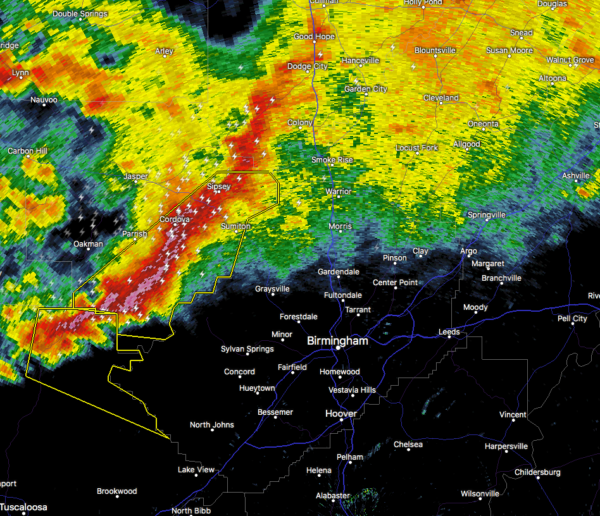
At 5:45 am, Doppler radar was tracking strong thunderstorms along a line extending from Rocky Hollow to near Gorgas Steam Plant to 6 miles northwest of Bankhead Lock And Dam. The movement was east at 50 mph.
Pea size hail and winds in excess of 40 mph will be possible with these storms.
Heads up if you are in Birmingham, Hoover, Vestavia Hills, Bessemer, Homewood, Mountain
Brook, Trussville, Hueytown, Gardendale, Irondale, Leeds, Moody, Fairfield, Fultondale, Sumiton, Center Point, Pleasant Grove, Clay, Pinson, and Tarrant.
Category: Alabama's Weather, ALL POSTS, Severe Weather
About the Author (Author Profile)
Scott Martin is an operational meteorologist, professional graphic artist, musician, husband, and father. Not only is Scott a member of the National Weather Association, but he is also the Central Alabama Chapter of the NWA president. Scott is also the co-founder of Racecast Weather, which provides forecasts for many racing series across the USA. He also supplies forecasts for the BassMaster Elite Series events including the BassMaster Classic.Subscribe
If you enjoyed this article, subscribe to receive more just like it.


