

Strong/Severe Storms Possible Late Today/Tonight
ACTIVE WEATHER: Showers and a few thunderstorms are moving northeast across Alabama early this morning as a warm front lifts northward; heaviest rain is over the northwest part of the state. The middle of the day should be fairly quiet, but we have potential for strong to severe thunderstorms over the northern half of the state late this afternoon and early tonight. SPC has defined a slight risk (level 2/5) of severe storms as far south as Millport, Birmingham, and Jacksonville… a “marginal risk” (level 1/5) is up down to Greensboro, Clanton, and Roanoke.
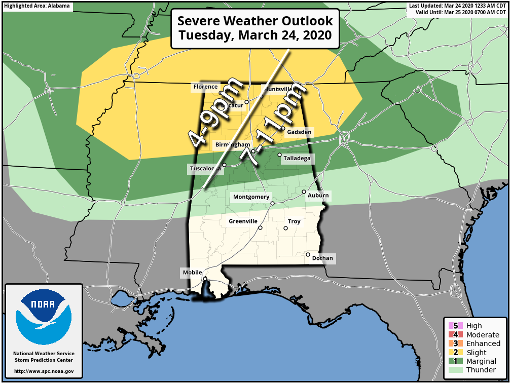
Storms late this afternoon and early tonight will be capable of producing hail and strong straight line winds. Also, an isolated tornado or two is certainly possible, especially in the “slight risk” area. Be sure you have a good way of hearing warnings if they are needed. And, if you typically go to a community shelter, check with our county EMA (Emergency Management Agency) to be sure it will be open. We are living in different times and you might need to adjust your normal severe weather plan when it comes to sheltering.
But remember, you must protect yourself from a tornado FIRST if you are in a polygon… then do the best you can when it comes to “social distancing”.
We also note there is a flash flood watch in effect through tonight for the Tennessee Valley region of North Alabama (Muscle Shoals to Huntsville to Scottsboro), where rain amounts of up to 2 inches are possible.
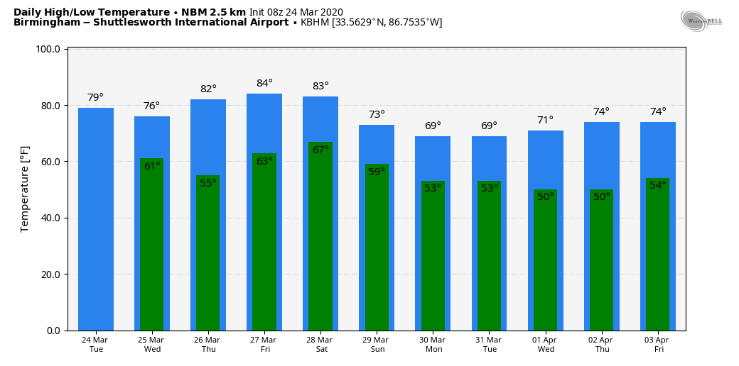
REST OF THE WEEK: Dry air returns tomorrow; the sky will be partly to mostly sunny with a high in the mid 70s. Then, look for the warmest weather so far this year Thursday and Friday… a sunny sky both days with highs in the mid 80s.
THE ALABAMA WEEKEND: A deep surface low is forecast to move into the Great Lakes region Saturday, with a trailing cold front slicing into Alabama Saturday night. SPC has defined a risk of severe storms for North and West Alabama for storms that form ahead of the front; for now it looks like the best chance of heavier thunderstorms will come late in the day and into Saturday night. Too early to be specific about the threat; we can do that later in the week as the event gets closer. Saturday will be warm with a high in the 80s… then Sunday will be dry and cooler with a high in the low 70s along with a good supply of sunshine.
NEXT WEEK: The latest global model runs show a fast moving disturbance with potential for a few showers Monday, otherwise the week looks fairly quiet with seasonal temperatures. See the Weather Xtreme video for maps, graphics, and more details.
ON THIS DATE IN 1975: “The Governor’s Tornado” hop-scotched a 13-mile path across the western part of Atlanta, GA during the early morning hours, causing considerable damage to the Governor’s mansion. Hundreds of expensive homes, businesses and apartment complexes were damaged. Total losses were estimated at $56 million. Three people lost their lives, and the F3 tornado injured another 152.
BEACH FORECAST: Click here to see the AlabamaWx Beach Forecast Center page.
WEATHER BRAINS: Don’t forget you can listen to our weekly 90 minute show anytime on your favorite podcast app. This is the show all about weather featuring many familiar voices, including our meteorologists here at ABC 33/40.
CONNECT: You can find me on all of the major social networks…
Facebook
Twitter
Instagram
Pinterest
Snapchat: spannwx
Look for the next Weather Xtreme video here by 4:00 this afternoon… enjoy the day!
Category: Alabama's Weather, ALL POSTS, Weather Xtreme Videos
About the Author (Author Profile)
James Spann is one of the most recognized and trusted television meteorologists in the industry. He holds the AMS CCM designation and television seals from the AMS and NWA. He is a past winner of the Broadcast Meteorologist of the Year from both professional organizations.Subscribe
If you enjoyed this article, subscribe to receive more just like it.


