

Strong Storm Affecting Portions Of Madison County
…SIGNIFICANT WEATHER ADVISORY FOR NORTHERN MADISON COUNTY UNTIL 4:15 PM CDT…
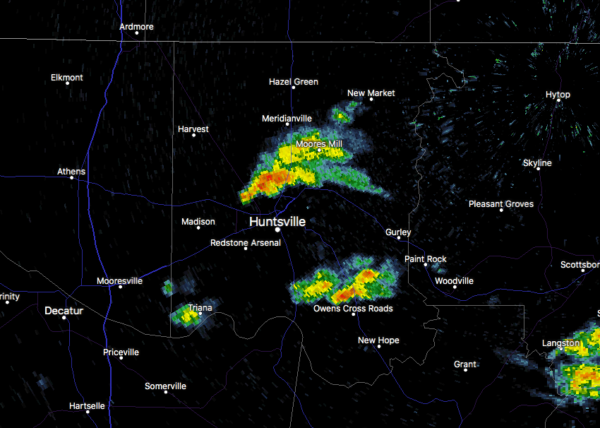
At 3:24 PM CDT, Doppler radar was tracking a strong thunderstorm over northwestern Huntsville, moving northeast at 30 mph. Pea size hail and winds in excess of 40 mph will be possible with this storm.
Heads up if you are in the following locations: Huntsville, Moores Mill, Meridianville, Redstone Arsenal, Alabama A&M University, University Of Alabama In Huntsville, New Market, Ryland, and Plevna.
Strong gusty winds will be capable of knocking down small tree limbs along with other small unsecured items. Seek safe shelter until this storm has passed.
Category: Alabama's Weather, ALL POSTS, Severe Weather
About the Author (Author Profile)
Scott Martin is an operational meteorologist, professional graphic artist, musician, husband, and father. Not only is Scott a member of the National Weather Association, but he is also the Central Alabama Chapter of the NWA president. Scott is also the co-founder of Racecast Weather, which provides forecasts for many racing series across the USA. He also supplies forecasts for the BassMaster Elite Series events including the BassMaster Classic.Subscribe
If you enjoyed this article, subscribe to receive more just like it.


