

A New Tornado Watch Likely By 9:30 PM That May Include NW Alabama
Here is the text from the latest Mesoscale Discussion from the Storm Prediction Center:
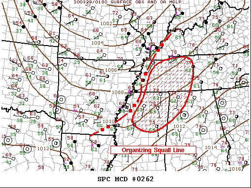
SUMMARY
A squall line is organizing and shifting east across Tornado Watch #71. A new tornado watch will likely be issued by 9:30 pm CDT.
Areas affected…
Northern MS
Northwest AL
Western/Middle TN
DISCUSSION…
Large-scale forcing appears to be aiding upward evolving squall line across the Mid-South this evening. Over the last few hours a slow maturation has been noted and its forward propagation is on the order of 35kt to the east. This speed/movement would place the leading edge of strongest convection near the eastern edge of Tornado Watch #71 around 10:00 pm and through much of Middle TN into northwestern AL by 1:00 am. A new tornado watch will likely be issued by 9:30 pm.
Category: Alabama's Weather, ALL POSTS, Severe Weather
About the Author (Author Profile)
Scott Martin is an operational meteorologist, professional graphic artist, musician, husband, and father. Not only is Scott a member of the National Weather Association, but he is also the Central Alabama Chapter of the NWA president. Scott is also the co-founder of Racecast Weather, which provides forecasts for many racing series across the USA. He also supplies forecasts for the BassMaster Elite Series events including the BassMaster Classic.Subscribe
If you enjoyed this article, subscribe to receive more just like it.


