

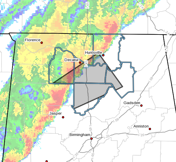
EXPIRED – Severe T-Storm Warning For Marshall, Madison, Limestone, Cullman, Morgan, & Lawrence Counties Until 3:30 AM
The National Weather Service in Huntsville Alabama has issued a
* Severe Thunderstorm Warning for…
Southwestern Marshall County in northeastern Alabama…
Southwestern Madison County in north central Alabama…
Southeastern Limestone County in north central Alabama…
Cullman County in north central Alabama…
Morgan County in north central Alabama…
Southeastern Lawrence County in northwestern Alabama…
* Until 330 AM CDT.
* At 251 AM CDT, a severe thunderstorm was located near Arley, moving
northeast at 70 mph.
HAZARD…60 mph wind gusts and quarter size hail.
SOURCE…Radar indicated.
IMPACT…Hail damage to vehicles is expected. Expect wind damage
to roofs, siding, and trees.
* Locations impacted include…
Southwestern Huntsville, Decatur, Madison, Cullman, Hartselle,
Arab, Redstone Arsenal, Hanceville, Priceville and Good Hope.
PRECAUTIONARY/PREPAREDNESS ACTIONS…
A Tornado Watch remains in effect until 500 AM CDT for north central,
northeastern and northwestern Alabama…and Middle Tennessee.
For your protection move to an interior room on the lowest floor of a
building.
Large hail and damaging winds and continuous cloud to ground
lightning is occurring with this storm. Move indoors immediately.
Lightning is one of nature’s leading killers. Remember, if you can
hear thunder, you are close enough to be struck by lightning.
Category: Alabama's Weather, ALL POSTS, Severe Weather
About the Author (Author Profile)
Scott Martin is an operational meteorologist, professional graphic artist, musician, husband, and father. Not only is Scott a member of the National Weather Association, but he is also the Central Alabama Chapter of the NWA president. Scott is also the co-founder of Racecast Weather, which provides forecasts for many racing series across the USA. He also supplies forecasts for the BassMaster Elite Series events including the BassMaster Classic.Subscribe
If you enjoyed this article, subscribe to receive more just like it.


