

Squall Line Will Be Moving Into Jefferson County Within The Next Few Minutes
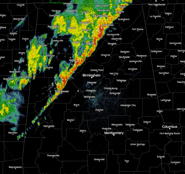
As of 3:33 am, the squall line of strong thunderstorms is stretching from Hytop down through Cullman to just outside of Tuscaloosa. Cells within the squall line are moving quickly to the northeast within the line, but the general progression to the east of the line as a whole is slow.
The good news is that all Severe Thunderstorm Warnings have expired and a few counties have been canceled from the Tornado Watch. Lawrence and Limestone counties were just removed from the Tornado Watch as the threat for severe storms have moved out of those locations.
More good news is that damage reports have been very light and have only dealt with a few trees falling. No power outages or structural damages reported in North/Central Alabama so far.
So far, the line of storms has had a decent bit of instability to work with, some of which actually increased before the line arrived in some locations in the northwestern parts of the area. We still have a little bit of instability to deal with over the northern half of the area ahead of the squall line that will keep thunderstorms going for a little while longer.
More good news is that the Significant Tornado Parameter values have dropped to around 1.0 in a small area along and just ahead of the line stretching from Shelby County up to the extreme southern parts of Madison County. We were seeing projected STP values up around 6.0 during the afternoon runs of the HRRR.
Category: Alabama's Weather, ALL POSTS, Severe Weather
About the Author (Author Profile)
Scott Martin is an operational meteorologist, professional graphic artist, musician, husband, and father. Not only is Scott a member of the National Weather Association, but he is also the Central Alabama Chapter of the NWA president. Scott is also the co-founder of Racecast Weather, which provides forecasts for many racing series across the USA. He also supplies forecasts for the BassMaster Elite Series events including the BassMaster Classic.Subscribe
If you enjoyed this article, subscribe to receive more just like it.


