

Three Confirmed Tornadoes Touched Down On Tuesday
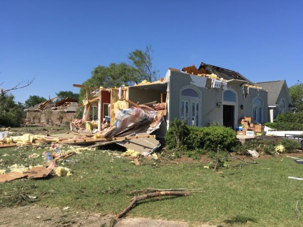
Image from NWS Birmingham.
NWS Birmingham continues to have damage assessments going but has already determined that there were three confirmed tornadoes that touched down in portions of the southeastern parts of the area. Information on the third tornado has not been released as of yet but appears to be an EF-0 that touched down near the Troy Airport. Here is the latest Public Information Statement from NWS Birmingham…
NWS DAMAGE SURVEY FOR 03/31/20 TORNADO EVENT
OVERVIEW
A strong upper-level disturbance caused a wave of low pressure to form along a quasi-stationary front and move eastward along the Highway 80 and Interstate 85 corridors. This allowed a warm front to lift northward across the southeast portions of Central Alabama. North of the warm front, a line of showers with sporadic lightning strikes along an inverted trough was able to produce damaging winds despite a cool and stable air mass at the surface, knocking down numerous trees from Tuscaloosa County to Randolph County during the first part of the morning. A QLCS ahead of the cold front moved eastward later in the morning from Lowndes County to Barbour County, producing damaging winds. Additionally, a bookend vortex and embedded supercell structures caused a weak tornado in northeast Pike County and a strong tornado near Eufaula.
Damage assessments are ongoing for additional potential tornado tracks.
TORNADO #1 Sandfield Tornado (Pike County)
Rating: ….. EF-0
Estimated Peak Wind: ….. 75 mph
Path Length (Statute): ….. 0.83 miles
Path Width (Maximum): ….. 180 yards
Fatalities: ….. 0
Injuries: ….. 0
Start Date: ….. Mar 31 2020
Start Time: ….. 10:51 AM CDT
Start Location: ….. 1 S Sandfield
Start Lat/Lon: ….. 31.9011 / -85.8111
End Date: ….. Mar 31 2020
End Time: ….. 10:52 AM CDT
End Location: ….. 1 ESE Sandfield
End Lat/Lon: ….. 31.9025 / -85.7972
Survey Summary: The tornado formed in a wooded rural area south of Highway 223 and the Sandfield community. Several trees were downed as it crossed an unnamed dirt road and County Road 6615. The tornado appeared to dissipate prior to reaching the Bullock County line. A brief tornado debris signature was also observed via KMXX radar.
TORNADO #2 Eufaula Tornado (Barbour County)
Rating: ….. EF-2
Estimated Peak Wind: ….. 130 mph
Path Length (Statute): ….. 7.85 miles
Path Width (Maximum): ….. 350 yards
Fatalities: ….. 0
Injuries: ….. 0
Start Date: ….. Mar 31 2020
Start Time: ….. 11:34 AM CDT
Start Location: ….. 3 ENE Baker Hill
Start Lat/Lon: ….. 31.8016 / -85.2636
End Date: ….. Mar 31 2020
End Time: ….. 11:46 AM CDT
End Location: ….. 5 S Eufaula
End Lat/Lon: ….. 31.8173 / -85.1313
Survey Summary: The tornado formed in a wooded area west of Lee Parker Lane, just north of Highway 131 and to the northeast of Baker Hill. It moved northeastward downing trees and causing minor roof damage to two residences along Five Mile Road and removing the roof from an outbuilding. It continued to snap numerous trees as it moved through a wooded area. It crossed Highway 131 near Leroy Road where two residences and a mobile home suffered minor damage as the tornado turned eastward. The tornado intensified as it crossed Highway 431, with the most significant damage occurring in the Country Club of Alabama neighborhood along the south side of Pebble Beach Drive. Large sections of roofs were removed from a few well-built residences with the collapse of some exterior walls. The tornado crossed the Walter F. George Reservoir along the Chattahoochee River and continued into Quitman County in Georgia.
EF Scale: The Enhanced Fujita Scale classifies tornadoes into the following categories.
EF0 … Weak … 65 to 85 mph
EF1 … Weak … 86 to 110 mph
EF2 … Strong … 111 to 135 mph
EF3 … Strong … 136 to 165 mph
EF4 … Violent … 166 to 200 mph
EF5 … Violent … >200 mph
Note: The information in this statement is preliminary and subject to change pending final review of the events and publication in NWS Storm Data.
Category: Alabama's Weather, ALL POSTS, Severe Weather
About the Author (Author Profile)
Scott Martin is an operational meteorologist, professional graphic artist, musician, husband, and father. Not only is Scott a member of the National Weather Association, but he is also the Central Alabama Chapter of the NWA president. Scott is also the co-founder of Racecast Weather, which provides forecasts for many racing series across the USA. He also supplies forecasts for the BassMaster Elite Series events including the BassMaster Classic.Subscribe
If you enjoyed this article, subscribe to receive more just like it.


