

A Quick Weather Check At 6:00 PM
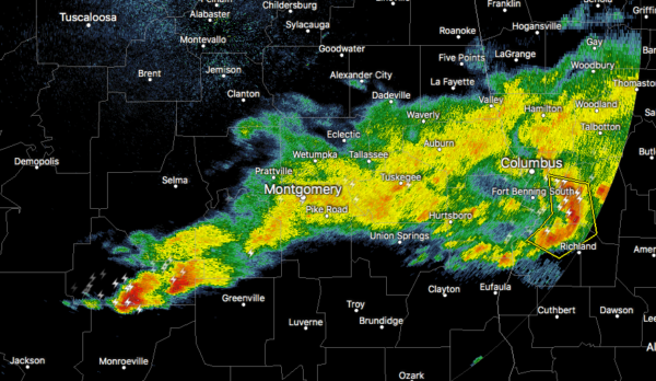
As we approach 6:00 pm, it is beginning to look like the severe storm threat for the southern parts of Central Alabama may be ending a little earlier than expected. There is a small line of showers and thunderstorms stretching from Fort Deposit and Lowndesboro in Lowndes County east-northeastward roughly following the I-85 corridor to Montgomery to Tuskegee to Opelika and crossing over into Georgia. None of these storms are acting up for the moment and are well below severe criteria.
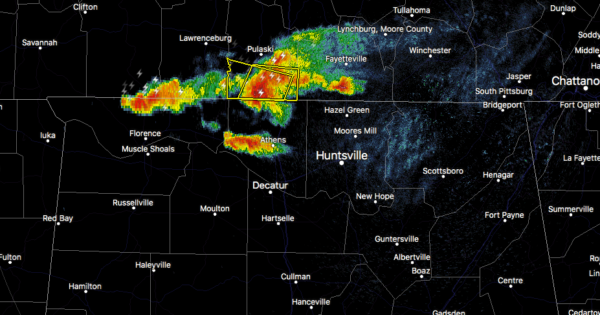
We also have some strong thunderstorms starting to cross over the AL/TN state line and is currently affecting portions of Lauderdale and Limestone counties. These are moving slowly to the east-southeast just below 30 MPH. Some gusty winds and small hail can be expected with the stronger cells.
We will need to watch those storms moving into Alabama from Tennessee as this air has been untapped and plenty of instability remains north of the Tennessee River.
Category: Alabama's Weather, ALL POSTS, Severe Weather
About the Author (Author Profile)
Scott Martin is an operational meteorologist, professional graphic artist, musician, husband, and father. Not only is Scott a member of the National Weather Association, but he is also the Central Alabama Chapter of the NWA president. Scott is also the co-founder of Racecast Weather, which provides forecasts for many racing series across the USA. He also supplies forecasts for the BassMaster Elite Series events including the BassMaster Classic.Subscribe
If you enjoyed this article, subscribe to receive more just like it.


