

Afternoon Update On The Severe Weather Threat Tomorrow
SPC has upgraded parts of West and Southwest Alabama to a “moderate risk” (level 4/5) of severe thunderstorms tomorrow/tomorrow night.
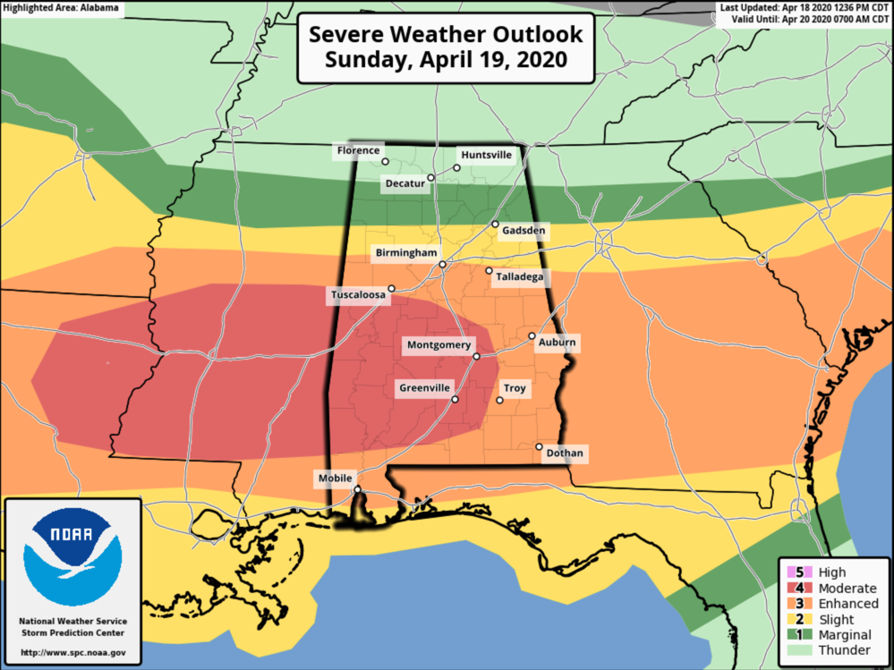
The greatest severe weather threat tomorrow will likely focus along/south of a warm front, which is expected to move to a point near I-20 by mid to late afternoon. A cold front is also forecast to sweep east-southeastward through the period in tandem with a developing surface low.
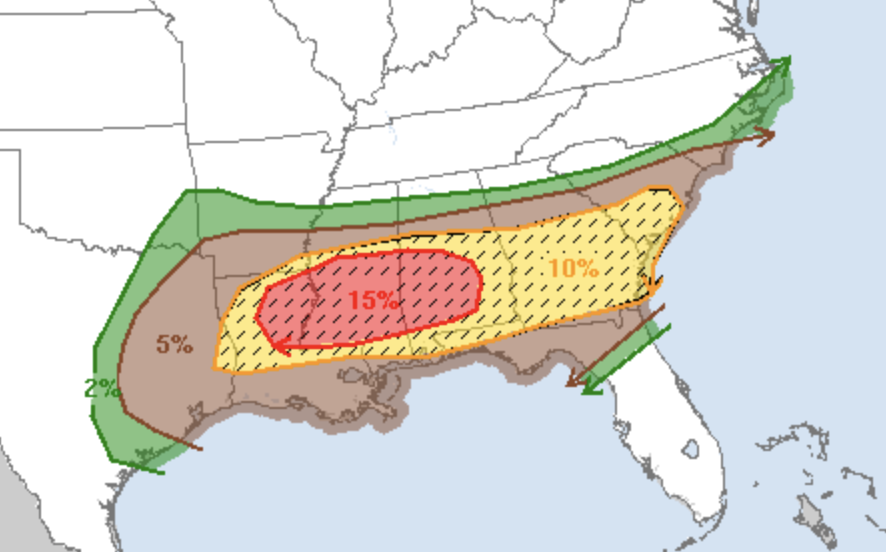
A corresponding increase in low-level shear combined with the strong deep-layer shear and moderate to locally strong instability suggests the potential for strong tornadoes with scattered supercells and clusters in a corridor extending from northern Louisiana into southern/central parts of Mississippi and Alabama tomorrow afternoon and evening. Scattered large hail and damaging winds, some of which could be significant, may also occur.
TIMING: A morning round of storms is expected between 4 and 11 a.m. These storms will be generally along and north of a northward moving warm front, and will be capable of producing hail and strong winds. They should be elevated, and tornadoes are not expected during that time frame.
Then, more thunderstorms are likely during the afternoon and evening hours, between 1pm and midnight. The pattern will be somewhat chaotic, and we can’t give specific arrival times for any one community. Just be aware that a storm is possible anytime during this 11 hour window. Highest tornado potential will be in the “moderate” and “enhanced” risk areas.
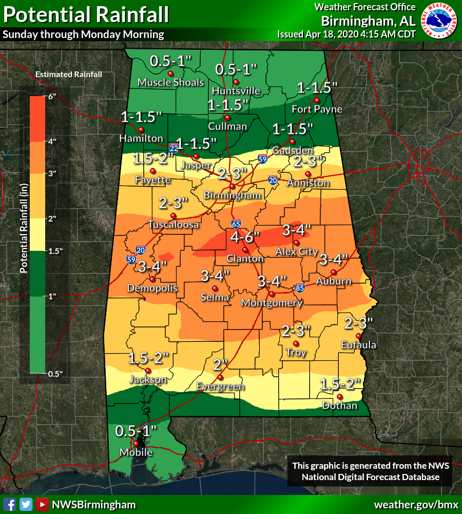
FLOODING: A flash flood watch is in effect for much of Central and South Alabama, where rain amounts of 2-4 inches are expected.
CALL TO ACTION: You know the drill; be sure you have a way of hearing severe weather warnings, and an action plan if you are in a tornado warning polygon.
*Have a NOAA Weather Radio in your home and business, properly programmed with a fresh battery in case of power failure.
*Be sure WEA (Wireless Emergency Alerts) enabled on your phone… this is not an app, but built into every phone sold in the U.S. Check settings, and notifications, and be sure emergency alerts are on. Have the free ABC 33/40 weather app on your phone as a secondary way of getting warnings. Search the App Store for “ABC 33/40 Weather” if you don’t have it already.
*In a site built home, identify the safe place. Small room, lowest floor, near the center of the house, away from windows. And, in that safe place, have helmets for everyone in the family (including adults!), portable air horns, and hard sole shoes.
*You can’t stay in a mobile home if you are in a tornado warning polygon. Know the closest shelter, and how to get there quickly.
*Sheltering from a tornado is first priority when it comes to the COVID-19 situation. A tornado is an immediate threat to life; get to your safe place or shelter and do the best you can to protect yourself from exposure to the virus.
As pointed out above, this system most likely won’t produce 24 tornadoes like last Sunday. But, all it takes is one tornado in the entire state. If that one comes through your neighborhood, it is YOUR red letter day. We all have to be prepared.
ANXIETY: I think Alabamians are tired of dealing with COVID-19, and after last Sunday, tired of dealing with severe weather. We don’t do this to scare anyone, or make them more anxious, but at the same time we have to let you know there is a risk of severe thunderstorms tomorrow. But remember, even on a big severe weather day, odds of any one place being hit by a tornado are low. We will get through the day together.
Category: Alabama's Weather, ALL POSTS, Severe Weather
About the Author (Author Profile)
James Spann is one of the most recognized and trusted television meteorologists in the industry. He holds the AMS CCM designation and television seals from the AMS and NWA. He is a past winner of the Broadcast Meteorologist of the Year from both professional organizations.Subscribe
If you enjoyed this article, subscribe to receive more just like it.


