


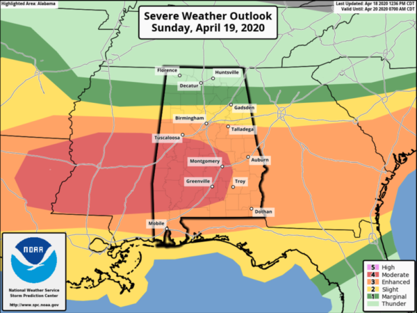
As of 8:20 pm, the Storm Prediction Center continues a MODERATE RISK (level 4 out of 5) for the southern and southwestern parts of Central Alabama for Sunday and into the pre-dawn hours on Monday morning. This includes locations south and west of a line from Memphis (Pickens Co.) to Clanton (Chilton Co.) to Cecil (Montgomery Co.) to Goshen (Pike Co.). The main threats will be from the potential for strong tornadoes, damaging winds up to and exceeding 70 MPH, and golf ball size hail.
An ENHANCED RISK (level 3 out of 5) continues for locations along and south of a line from Millport (Lamar Co.) to Birmingham (Jefferson Co.) to just north of Woodland (Randolph Co.). The main threats will be from the potential for tornadoes, damaging winds up to and exceeding 70 MPH, and golf ball size hail.
A SLIGHT RISK (level 2 out of 5) continues for locations above that to as far north as Guin (Marion Co.) to Oneonta (Blount Co.) to Pleasant Gap (Cleburne Co.). The main threats will be from the potential for brief tornadoes, damaging winds up to and exceeding 60 MPH, and quarter size hail.
A MARGINAL RISK (level 1 out of 5) continues for locations as far north as Russellville (Franklin Co.) to Priceville (Morgan Co.) to Fort Payne (Dekalb Co.). The main threats of the potential for brief tornadoes, damaging winds up to and exceeding 60 MPH, and quarter size hail are less likely, but cannot be completely ruled out.
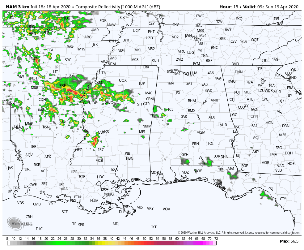
This animated radar simulation is from the 18 NAM-3k valid from 4:00 am to 11:00 am on Sunday morning, which is the time frame for the first window for the potential of stronger to severe storms. Showers and thunderstorms will be moving eastward along and ahead of a warm front as it moves northward through Central Alabama. These storms will be elevated in nature, but still could produce damaging winds up to 60 MPH and golf ball size hail. The tornado threat with these storms will be very low, but not zero.
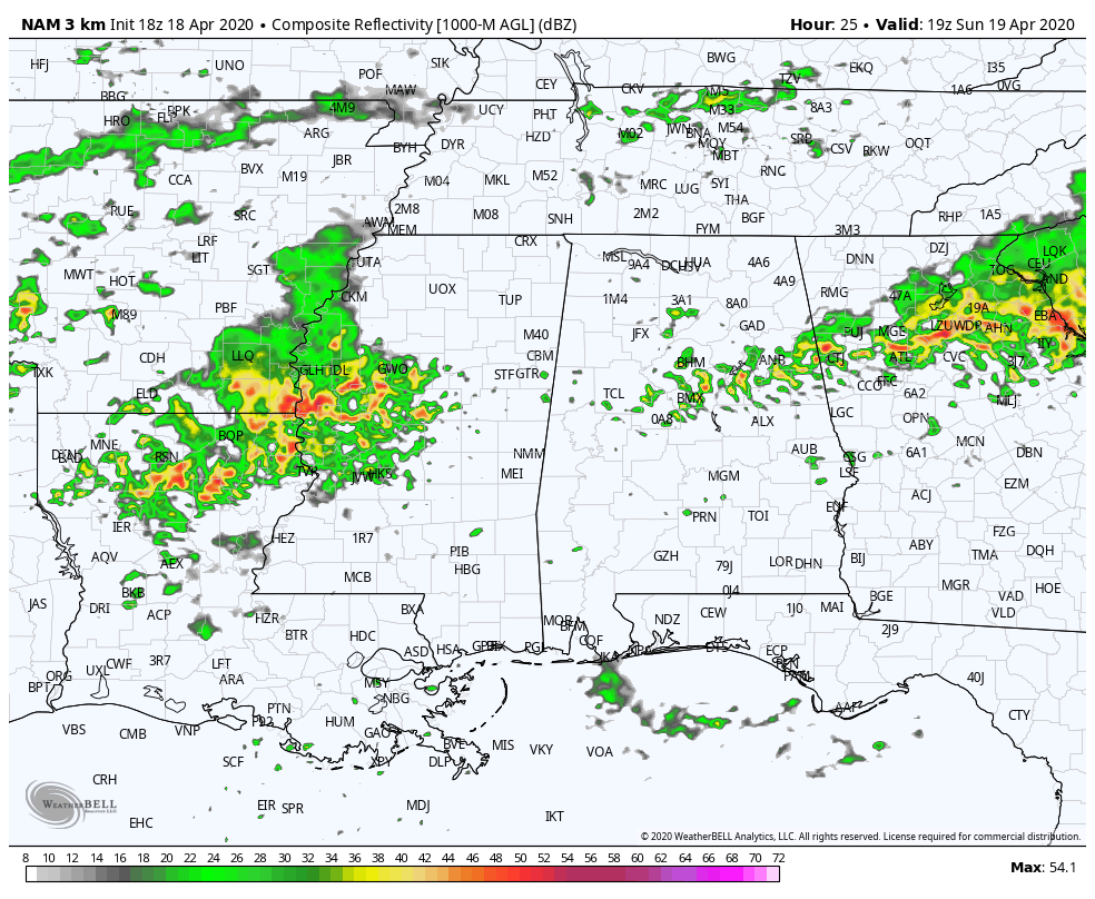
This animated radar simulation is from the 18 NAM-3k valid from Sunday at 2:00 pm to 2:00 am on Monday morning, which is the time frame for the second window for the potential of stronger to severe storms. These storms will be moving in with the surface low and shortwave and will progress across the area during that window. Ingredients will be in place for severe storms which include all modes of severe weather. We’ll even have to watch for discreet supercells that may form outside of any thunderstorm clusters as these will contain a larger threat of stronger tornadoes.
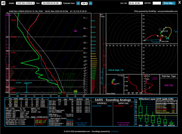
This is a projected forecast sounding from the same run of the NAM-3k that is valid at 1:00 am Monday for roughly around Sweet Water in Marengo County. Forecast instability will be around 3400 J/kg, which is plenty of fuel for thunderstorms. Storm-relative helicity will be around 234 m2/s2 which is plenty enough to support rotating storms. Lapse rates will be steep, around 7.3ºC/km which means there will be cold air aloft and also supportive of stronger storm updrafts. Therefore, this sounding is placing the possible hazard type as PDS Tornado (particularly dangerous situation. Ingredients similar to this can be found for nearly all of the Moderate Risk locations.
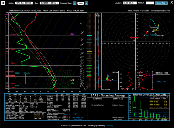
This is the projected forecast sounding for the Birmingham metropolitan area valid Sunday night around 10:00 pm. At this time, the low will be passing just to the south of the city and therefore the atmosphere will be more stable. While storm-relative helicity and lapse rates remain high enough to be supportive of rotating strong updrafts, instability will be meager at best. Possible hazard type is only showing Marginal Severe which means isolated damaging winds up to 60 MPH and isolated hail up to quarter size are possible, but not likely. A brief tornado can’t be ruled out, but that would be highly unlikely.
It looks like a boundary will set up during the afternoon and evening hours just south of the I-20 corridor which will keep much of the severe activity along and south of the boundary, therefore the higher risks have been placed in those locations. New model runs may paint a different picture and this forecast will have to be adjusted if that is the case.
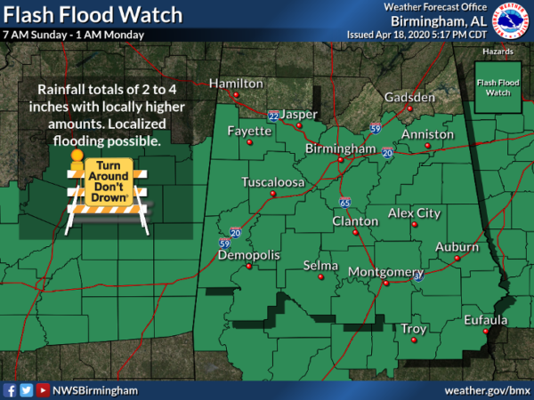
A FLASH FLOOD WATCH also goes into effect at 7:00 am Sunday morning and is set to expire at 1:00 am Monday morning. Rainfall amounts throughout the watch area are expected to be in the 2-4 inch range with localized heavier amounts.
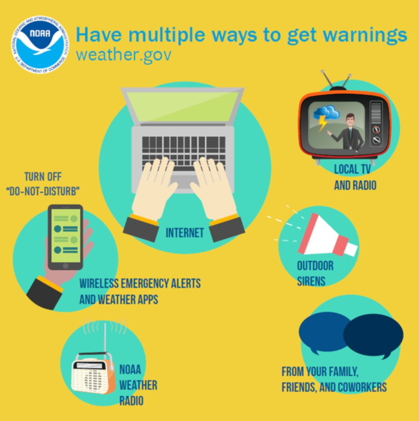
You know the drill… Have your emergency kits fully packed, your safe place, and your severe weather action plan ready to go. Have multiple ways of receiving warnings. Do not rely just simply on outdoor sirens.
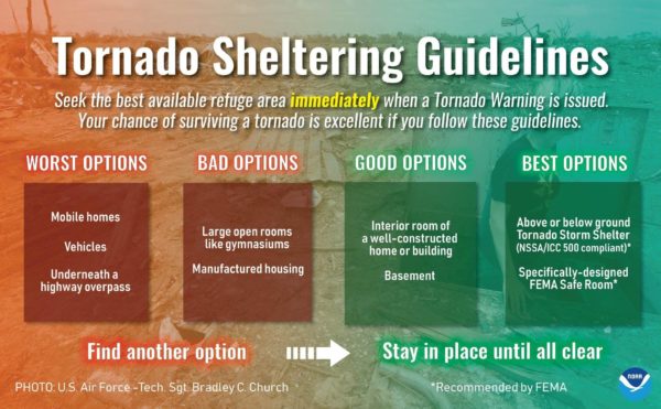
Do not attempt to ride out a tornado warning in a mobile/manufactured home or in a car. You have time to make plans to go to a more sturdy structure or a local tornado shelter. You do this, your chance of surviving a tornado is excellent, especially if you plan well ahead of the event and are ready to act if a warning is issued for your location.


