

EXPIRED – Tornado Warning for Pike & Barbour Counties Until 11:45 PM
The National Weather Service in Birmingham has issued a
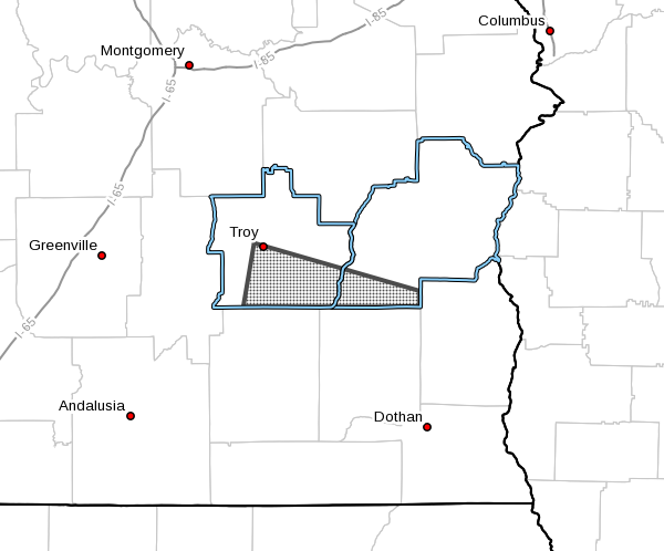
* Tornado Warning for…
Southeastern Pike County in southeastern Alabama…
Southwestern Barbour County in southeastern Alabama…
* Until 1145 PM CDT.
* At 1059 PM CDT, a severe thunderstorm capable of producing a
tornado was located near Troy University, or near Troy, moving east
at 55 mph.
HAZARD…Tornado.
SOURCE…Radar indicated rotation.
IMPACT…Flying debris will be dangerous to those caught without
shelter. Mobile homes will be damaged or destroyed.
Damage to roofs, windows, and vehicles will occur. Tree
damage is likely.
* Locations impacted include…
Troy, Brundidge, Clio, Doster, Antioch, Blue Springs State Park,
Troy University, Tennille, Hamilton Crossroads, Tarentum, Brundidge
Municipal Airport and Mossy Grove.
PRECAUTIONARY/PREPAREDNESS ACTIONS…
TAKE COVER NOW! Move to a basement or an interior room on the lowest
floor of a sturdy building. Avoid windows. If you are outdoors, in a
mobile home, or in a vehicle, move to the closest substantial shelter
and protect yourself from flying debris.
Category: Alabama's Weather, ALL POSTS, Severe Weather
About the Author (Author Profile)
Scott Martin is an operational meteorologist, professional graphic artist, musician, husband, and father. Not only is Scott a member of the National Weather Association, but he is also the Central Alabama Chapter of the NWA president. Scott is also the co-founder of Racecast Weather, which provides forecasts for many racing series across the USA. He also supplies forecasts for the BassMaster Elite Series events including the BassMaster Classic.Subscribe
If you enjoyed this article, subscribe to receive more just like it.


