

A Very Beautiful & Pleasant Midday; Severe Storms Possible On Wednesday
NO WEATHER ISSUES AT MIDDAY FOR THE LAST MONDAY OF APRIL
At the midday hour, we have a clean sweep on the visible satellite view across Central Alabama. Not a single cloud is showing up at this time. If there is a small one floating in the sky, it is too small to be seen by the satellite. Temperatures as of the 12:00 pm round-up were in the mid-60s to the lower 70s across the area. Montgomery and Troy were the warm spots at 71 degrees. The cool spots were Gadsden and Sylacauga at 65 degrees. Birmingham was at 67 degrees.
Most of the area will stay cloud-free for the remainder of the afternoon and into the early evening hours, but a few higher clouds may move into the northern and northwestern parts of the area. Afternoon highs will range from the lower 70s in the north to the upper 70s in the extreme southeastern parts of the area. A few clouds may remain over the northern parts of the area during the overnight hours, but most of Central Alabama will have clear skies. Lows will range from the upper 40s to the lower 50s.
ANOTHER THREAT OF SEVERE STORMS FOR YOUR WEDNESDAY
A strong trough and associated cold front will bring showers and thunderstorms to Central Alabama starting as early as just before sunrise and will be out of the area just before your late local news. There is a threat for strong to severe storms with this system, especially from 12:00 pm to 8:00 pm across nearly all of the area with the exception of the northwestern corner. This system will affect the area in two waves with the first wave being the weaker of the two. The second wave is the one we’ll have to really watch for damaging winds up to 60 MPH, large hail up to quarter size (1-inch in diameter), and a brief tornado or two.
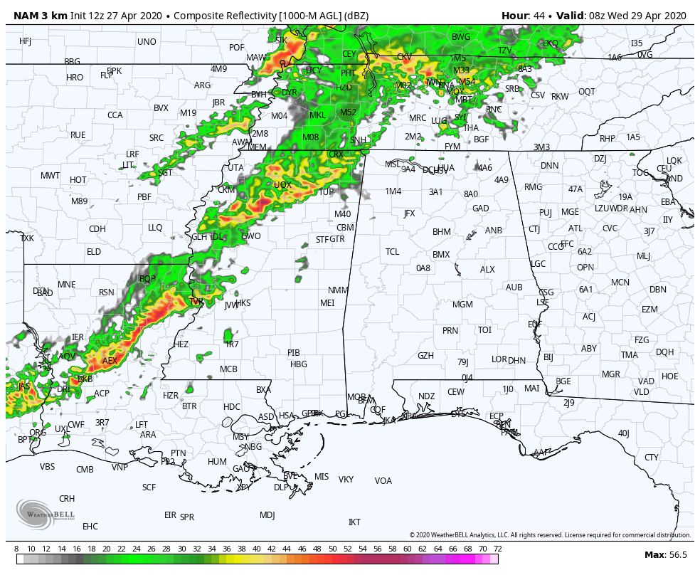
The above animation is the latest simulated radar run from the high-resolution NAM valid from Wednesday starting at 3:00 am and ending at 7:00 pm. A weakening band of showers and thunderstorms will begin to push into the northwestern corner of the state around 3:00 am and eventually start to move into the northwestern parts of Central Alabama around or just before 6:00 am. It will make it to the I-59 corridor around or just before 8:00 am while continuing to weaken and eventually nearly falling apart around 11:00 am.
After 11:00 am is when we’ll have to watch and see what can get going over the northwestern parts of the area, because as you can see, much of the southern and southeastern parts will not have that much activity move through and that will allow the atmosphere to recover.
As we continue to move on through the afternoon hours, more showers and storms look to form in the destabilizing air that will have a good bit of instability and will eventually become a line of potentially strong to severe storms around 4:00 pm. This line looks to continue to grow stronger as it pushes eastward before exiting the area around 8:00 pm. This model run ends at 7:00 pm as that is the end of the 60-hour forecast period for the high-resolution NAM.
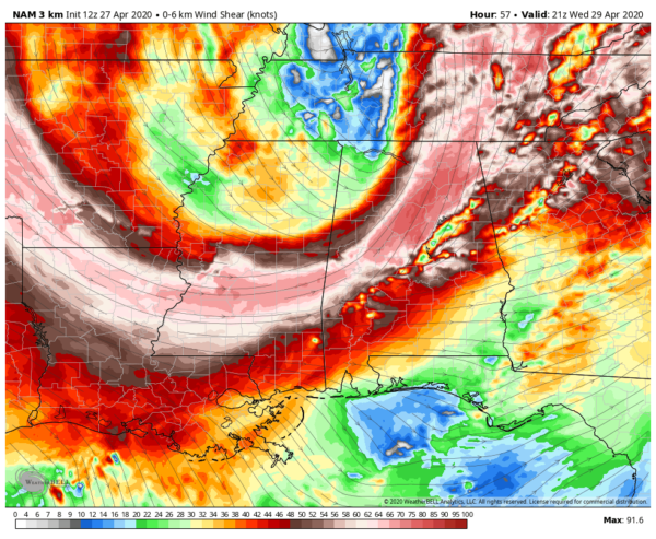
The above image is the wind shear around 4:00 pm and we see that a low-level jet will be moving over the I-59 corridor with winds topping out around 70-75 knots. Wind shear is the change in the wind throughout a certain height range, which for this image is set from ground-level to 6 km up in the atmosphere. Supercells are usually associated with shear values of 35-40 knots and greater at this height lever.
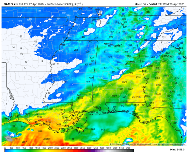
This image is the instability at 4:00 pm, also known as convective available potential energy, or CAPE. It shows the total amount of potential energy (or fuel for the storms) available for air parcels rising from the surface to the free convection height. Values of 500-1500 J/kg are considered moderately unstable, 1501-2500 J/kg is strongly unstable, and anything greater than 2500 J/kg is considered extremely unstable. Much of the instability for along and north of the I-59 corridor is less than 500 J/kg while south of that, we see values reaching 2000 J/kg.
These values show that there will be a threat of strong to severe storms with damaging winds and large hail being the main focus, but a brief tornado or two will be possible as well, just on a much lower threat level.
ON THIS DATE IN WEATHER HISTORY
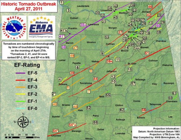
APRIL 27, 2011 (from NWS Birmingham)- there were two distinct waves of widespread severe weather in Central Alabama. The first wave of severe storms moved through during the early morning hours across northern portions of Central Alabama in the form of a Quasi-Linear Convective System (QLCS). This intense line of thunderstorms produced not only widespread damaging straight-line winds in the areas of Moody, Pell City, and Riverside, but numerous strong tornadoes as well.
The second wave, which began with the Hackleburg EF-5 tornado, involved numerous supercell thunderstorms which produced deadly long-lived, strong to violent tornadoes across the northern two-thirds of Central Alabama. Widespread and catastrophic damage was sustained in several locations.
In total, there were 29 confirmed tornadoes in Central Alabama on this day, and 62 confirmed tornadoes across the State of Alabama. 252 people were killed and thousands injured by large, violent tornadoes.
Category: Alabama's Weather, ALL POSTS, Severe Weather
About the Author (Author Profile)
Scott Martin is an operational meteorologist, professional graphic artist, musician, husband, and father. Not only is Scott a member of the National Weather Association, but he is also the Central Alabama Chapter of the NWA president. Scott is also the co-founder of Racecast Weather, which provides forecasts for many racing series across the USA. He also supplies forecasts for the BassMaster Elite Series events including the BassMaster Classic.Subscribe
If you enjoyed this article, subscribe to receive more just like it.


