


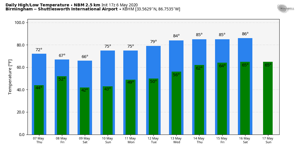
WINDY, COOL MAY DAY: Strong north winds of 15-25 mph are ushering in cool air into Alabama this afternoon as expected; temperatures are mostly in the 68-73 degree range, but we note Cullman reports only 60 degrees at 2:00. The average high for Birmingham on May 6 is 79. The sky is sunny over the southern two-thirds of the state, but some clouds have dropped down into North Alabama. Those clouds will dissipate tonight, and with a clear sky and diminishing wind we project a low in the 40-45 degrees range for most communities early tomorrow.
Tomorrow will feature a good supply of sunshine with a high in the low 70s. Clouds will increase tomorrow night, however.
FRIDAY AND THE WEEKEND: A cold front will bring showers back into Alabama Friday. We aren’t expecting any surface based instability, meaning no risk of severe thunderstorms and probably no thunder. Rain should be 1/2 inch or less, and the sky will clear Friday night. Temperatures will hold in the 60s Friday with clouds and showers.
The weekend will be dry with cold mornings. Look for lows between 37 and 43 early Saturday and Sunday; some scattered light frost is possible across colder spots Sunday morning when the wind will be near calm. The high Saturday will be in the mid 60s, followed by low 70s Sunday. Dry air means a sunny sky both days.
Here are the record lows for Birmingham…
Saturday (May 9) 40 (1984)
Sunday (May 10) 38 (1966)
We will be pretty close to those levels both mornings over the weekend.
NEXT WEEK: For now the week looks rain-free with a warming trend. Highs will be in the 70s Monday and Tuesday, close to 80 Wednesday, followed by mid 80s Thursday and Friday. See the Weather Xtreme video for maps, graphics, and more details.
No sign of any severe weather or excessive rain issues for Alabama over the next seven to ten days.
ON THIS DATE IN 1975: A massive tornado hit Omaha, Nebraska killing three persons, injuring 133 others, and causing over 250 million dollars damage. The tornado struck during the late afternoon moving northeastward through the industrial and residential areas of west-central Omaha and lifting over the northern section of the city. The twister, which cut a swath ten miles long and as much as a quarter of a mile wide. It was the most costly in U.S. history up till that time.
BEACH FORECAST: Click here to see the AlabamaWx Beach Forecast Center page.
WEATHER BRAINS: Don’t forget you can listen to our weekly 90 minute show anytime on your favorite podcast app. This is the show all about weather featuring many familiar voices, including our meteorologists here at ABC 33/40.
CONNECT: You can find me on all of the major social networks…
Facebook
Twitter
Instagram
Pinterest
Snapchat: spannwx
Look for the next Weather Xtreme video here by 7:00 a.m. tomorrow…


