

Weather Xtreme: Mainly Dry Today, Higher Rain Chances on Sunday
THE CENTRAL ALABAMA WEEKEND
Saturday will be a very warm to hot day across Central Alabama with partly to mostly sunny skies with only a very slight chance of a shower or thunderstorm along the Mississippi state line. Afternoon highs will reach the upper 80s to the lower 90s across the area from northwest to southeast.
Rain chances will be a little bit higher across the western parts of the area on Sunday, but much of the area will stay dry throughout much of the daylight hours. Rain chances will begin to increase across the area starting in the late afternoon to early evening as a cold front will be approaching from the west with storms moving in during the late-night and through the overnight hours. Highs will be in the upper 80s to the lower 90s as skies will continue to be partly to mostly sunny during the day.
NEXT WEEK
The cold front moves through the area on Monday which will bring Central Alabama an increased risk of scattered showers and thunderstorms during the morning hours, but the activity should be out of here by the afternoon and cooler air will begin to move in late. We’ll have more clouds than sun and highs will be in the upper 70s to the mid-80s. At this point, severe storms are not expected.
An upper low will get hung up for the rest of the workweek just to our northeast which will keep us in drier, continental air, but those temperatures will begin to increase in time. We’ll have a mix of sun and clouds on Tuesday with highs reaching the lower 70s to the lower 80s. Wednesday will feature more sun than clouds and highs in the mid-70s to the lower 80s. Much of the same on Thursday, only being a little bit warmer with highs reaching the upper 70s to the mid-80s. The heat is back on Friday as highs will be back up in the mid-80s to the lower 90s with mostly sunny skies.
TROPICAL TROUBLE
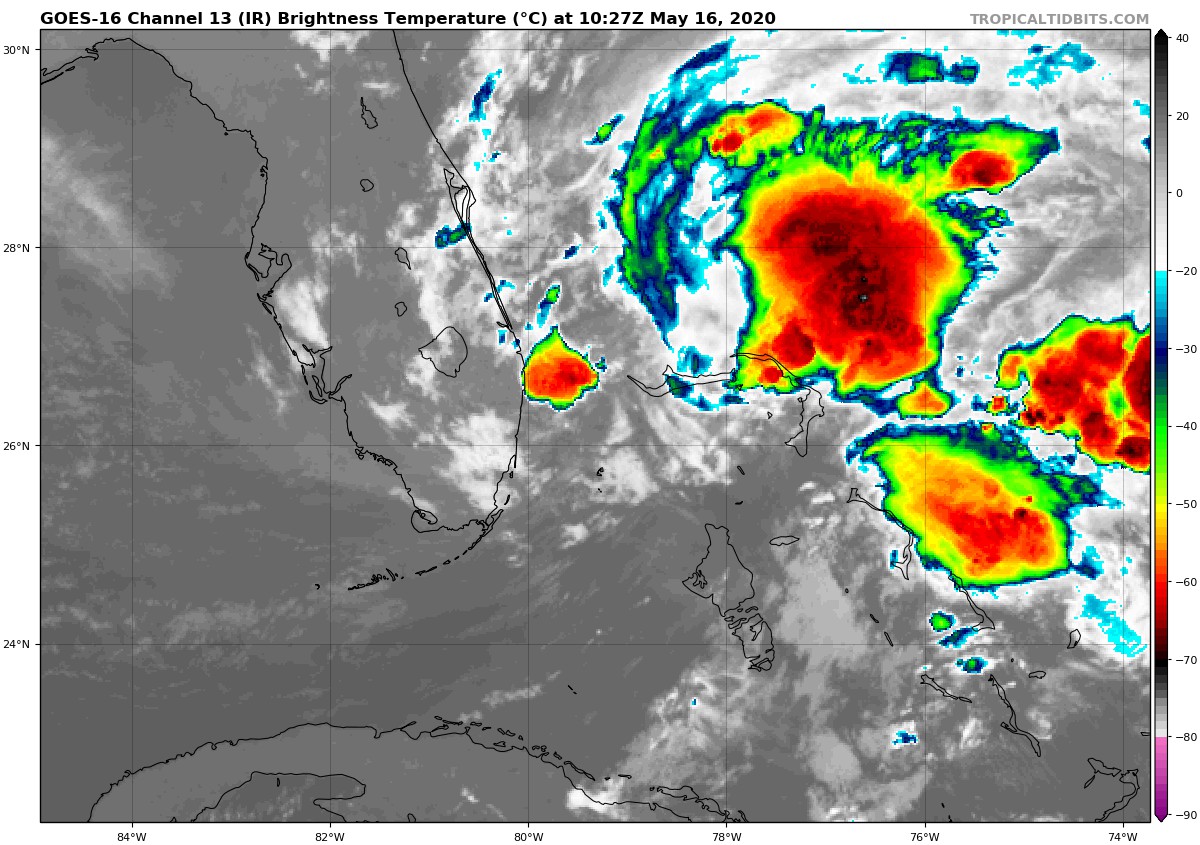
As of 5:00 am this morning, the surface low of Invest 90L was located just to the east of the southern tip of the Florida Keys with winds only maxing out at approximately 25 knots. Conditions will become more favorable today and we could have a tropical/subtropical storm form just northwest of the Bahamas as it will be moving off to the northeast later in the day. If it does become classified as a storm, its name will be Arthur.
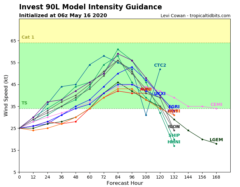
Most model members keep it as a mid-level tropical/subtropical storm, but a couple of members have it becoming a strong tropical/subtropical storm with winds at or over 55 knots. It will eventually move on out to sea, but rough surf, dangerous rip currents, gusty winds, and tropical rainfall will be possible for the eastern parts of the Florida peninsula up to the outer banks of North Carolina through the weekend. None of this tropical activity will affect our weather in Central Alabama.
ON THIS DAY IN WEATHER HISTORY
1989 – Thunderstorms developing ahead of a cold front produced severe weather in the south-central U.S. Thunderstorms spawned twenty tornadoes, and there were 180 reports of large hail and damaging winds. A tornado at Cleburne, TX, caused 30 million dollars damage. A violent (F-4) tornado touched down near Brackettville, TX, and a strong (F-3) tornado killed one person and injured 28 others at Jarrell, TX. Thunderstorms also produced softball size hail at Shamrock, TX.
1990 – Thunderstorms produced severe weather from eastern Oklahoma and northeastern Texas to the Upper Ohio Valley. Thunderstorms spawned seventeen tornadoes, including a twister that killed one person and injured another north of Corning, AR. There were 128 reports of large hail or damaging winds. Strong thunderstorm winds killed one person and injured six others at Folsomville, IN, and injured another five persons in southeastern Hardin County KY. In Arkansas, baseball size hail was reported near Fouke and near El Dorado.
BEACH FORECAST
Get the latest weather and rip current forecasts for the beaches from Bay St. Louis, MS, to Panama City Beach, FL, on our Beach Forecast Center page. There, you can select the forecast of the region that you are interested in.
ADVERTISE ON THE BLOG!
We had another fantastic year in 2019 with just over 17 million page views! That brings our total for the last 2 years close to 37 million page views! Don’t miss out! We can customize a creative, flexible, and affordable package that will suit your organization’s needs. Contact Bill Murray at (205) 687-0782.
E-FORECAST
Get the Alabama Wx Weather Blog’s Seven-Day Forecast delivered directly to your inbox by email twice daily. It is the most detailed weather forecast available in Central Alabama. Subscribe here… It’s free!
CONNECT WITH THE BLOG ON SOCIAL MEDIA
You can find the AlabamaWx Weather Blog on the major social media networks:
Facebook
Twitter
Instagram
Category: Alabama's Weather, ALL POSTS, Tropical, Weather Xtreme Videos
About the Author (Author Profile)
Scott Martin is an operational meteorologist, professional graphic artist, musician, husband, and father. Not only is Scott a member of the National Weather Association, but he is also the Central Alabama Chapter of the NWA president. Scott is also the co-founder of Racecast Weather, which provides forecasts for many racing series across the USA. He also supplies forecasts for the BassMaster Elite Series events including the BassMaster Classic.Subscribe
If you enjoyed this article, subscribe to receive more just like it.


