

We Now Have Tropical Storm Arthur
…RECONNAISSANCE AIRCRAFT FINDS THE DEPRESSION EAST OF FLORIDA HAS
STRENGTHENED INTO TROPICAL STORM ARTHUR…
…A TROPICAL STORM WATCH REMAINS IN EFFECT FOR PORTIONS OF THE
NORTH CAROLINA COAST…
SUMMARY OF 1100 PM EDT…0300 UTC…INFORMATION
———————————————–
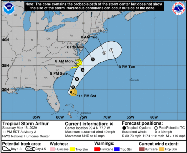
LOCATION…29.4N 77.7W
ABOUT 190 MI…305 KM ENE OF CAPE CANAVERAL FLORIDA
ABOUT 420 MI…675 KM SSW OF CAPE HATTERAS NORTH CAROLINA
MAXIMUM SUSTAINED WINDS…40 MPH…65 KM/H
PRESENT MOVEMENT…NNE OR 30 DEGREES AT 13 MPH…20 KM/H
MINIMUM CENTRAL PRESSURE…1006 MB…29.71 INCHES
WATCHES AND WARNINGS
——————–
CHANGES WITH THIS ADVISORY:
None.
SUMMARY OF WATCHES AND WARNINGS IN EFFECT:
A Tropical Storm Watch is in effect for…
* Surf City to Duck NC
* Pamlico and Albemarle Sounds
A Tropical Storm Watch means that tropical storm conditions are
possible within the watch area, generally within 48 hours.
A Tropical Storm Warning could be required for portions of the
Watch area by Sunday morning.
For storm information specific to your area, including possible
inland watches and warnings, please monitor products issued by your
local National Weather Service forecast office.
DISCUSSION AND OUTLOOK
———————-
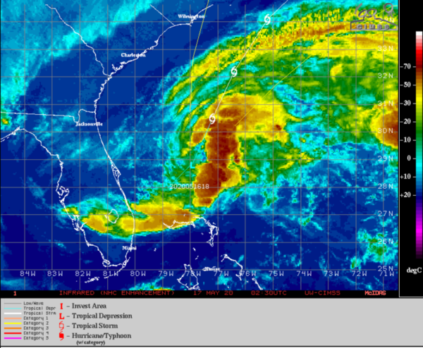
At 1100 PM EDT (0300 UTC), the center of Tropical Storm Arthur was
located by an Air Force Reserve reconnaissance aircraft near
latitude 29.4 North, longitude 77.7 West. Arthur is moving toward
the north-northeast near 13 mph (20 km/h). A motion toward the
north-northeast or northeast is expected tonight and Sunday. After
that time, a faster northeastward motion is expected on Monday. On
the forecast track, Arthur will remain well offshore the east coast
of Florida and Georgia tonight and Sunday, and then move near or
east of the coast of North Carolina on Monday.
Data from the reconnaissance aircraft indicate that maximum
sustained winds have increased to near 40 mph (65 km/h) with higher
gusts. Additional strengthening is forecast during the next 48
hours.
Tropical-storm-force winds extend outward up to 80 miles (130 km)
from the center.
The minimum central pressure based on reports from the
reconnaissance aircraft is estimated to be 1006 mb (29.71 inches).
HAZARDS AFFECTING LAND
———————-
WIND: Tropical storm conditions are possible within the watch
area on Monday.
RAINFALL: Arthur is expected to produce additional rain
accumulations of 1 to 2 inches over the central and northwest
Bahamas, and generally less than 1 inch over south Florida through
tonight. Arthur is also expected to produce total rain
accumulations of 1 to 2 inches over coastal North Carolina Sunday
night and Monday.
SURF: Swells generated by Arthur are affecting portions of
the east coast of central and northern Florida. These swells are
expected to spread northward during the next few days, and could
cause life-threatening surf and rip current conditions across much
of the U.S. southeast and mid-Atlantic coasts. Please consult
products from your local weather office.
Category: Alabama's Weather, ALL POSTS, Tropical
About the Author (Author Profile)
Macon, Georgia Television Chief Meteorologist, Birmingham native, and long time Contributor on AlabamaWX. Stormchaser. I did not choose Weather, it chose Me. College Football Fanatic. @Ryan_StinnetSubscribe
If you enjoyed this article, subscribe to receive more just like it.


