

CANCELED: Severe T-Storm Warning for Colbert & Lauderdale Co. Until 7:45 pm
The National Weather Service in Huntsville Alabama has issued a
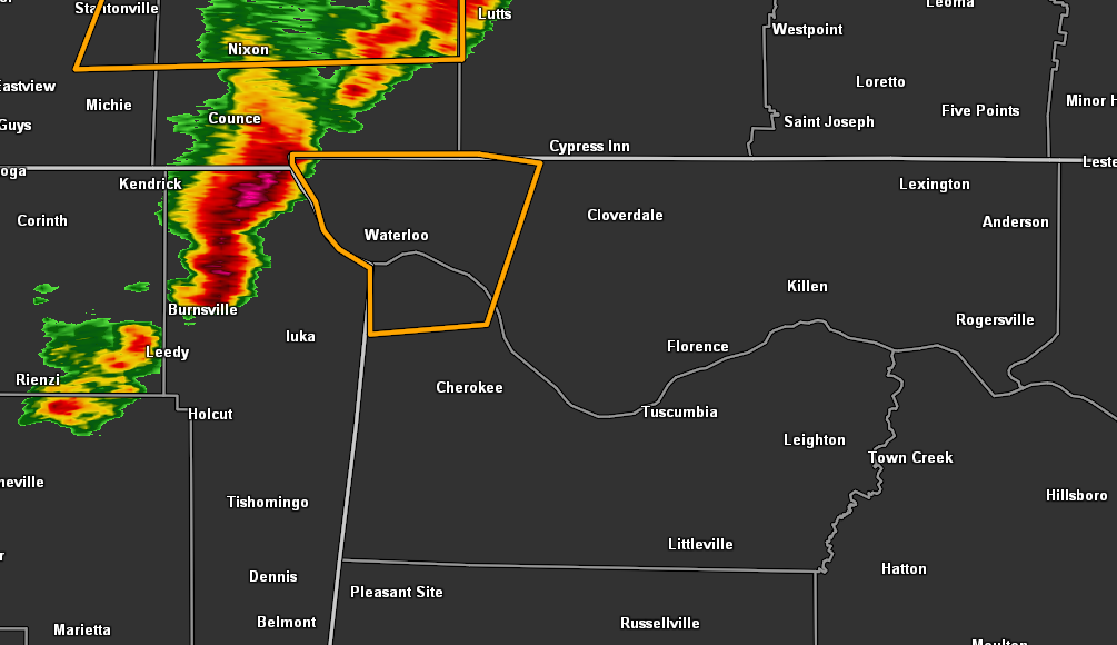
* Severe Thunderstorm Warning for…
Northwestern Lauderdale County in northwestern Alabama…
Northwestern Colbert County in northwestern Alabama…
* Until 745 PM CDT.
* At 709 PM CDT, a severe thunderstorm was located over Pineflat, or
near Pickwick Landing State Park, moving southeast at 30 mph.
HAZARD…60 mph wind gusts and quarter size hail.
SOURCE…Radar indicated.
IMPACT…Hail damage to vehicles is expected. Expect wind damage
to roofs, siding, and trees.
* Locations impacted include…
Waterloo, Riverton and Wright.
PRECAUTIONARY/PREPAREDNESS ACTIONS…
Prepare immediately for large hail and deadly cloud to ground
lightning. Seek shelter inside a well-built structure. Stay away from
windows.
Category: Alabama's Weather, ALL POSTS, Severe Weather
About the Author (Author Profile)
Scott Martin is an operational meteorologist, professional graphic artist, musician, husband, and father. Not only is Scott a member of the National Weather Association, but he is also the Central Alabama Chapter of the NWA president. Scott is also the co-founder of Racecast Weather, which provides forecasts for many racing series across the USA. He also supplies forecasts for the BassMaster Elite Series events including the BassMaster Classic.Subscribe
If you enjoyed this article, subscribe to receive more just like it.


