

CANCELED: Severe T-Storm Warning for Marshall Co. Until 9:00 pm
The National Weather Service in Huntsville Alabama has issued a
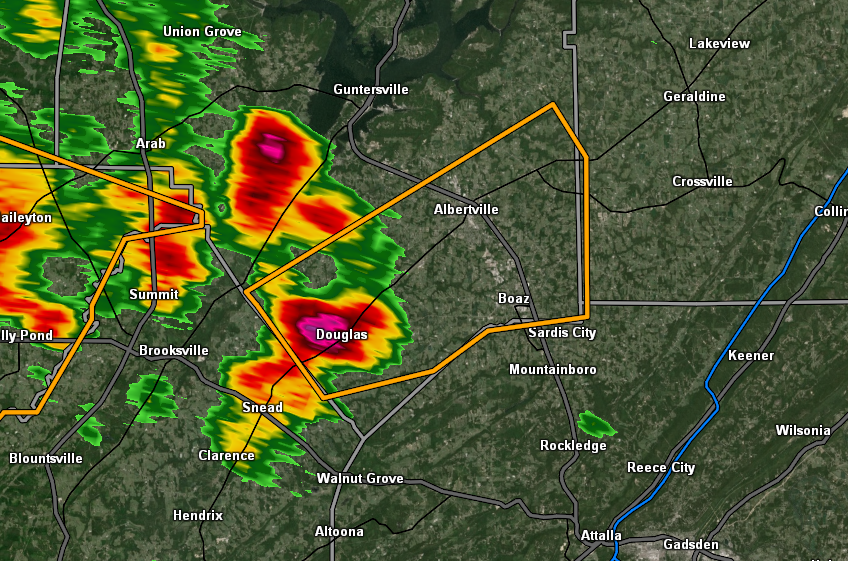
* Severe Thunderstorm Warning for…
Southeastern Marshall County in northeastern Alabama…
* Until 900 PM CDT.
* At 830 PM CDT, a severe thunderstorm was located near McLarty, or 8
miles southwest of Albertville, moving east at 30 mph.
HAZARD…60 mph wind gusts and quarter size hail.
SOURCE…Radar indicated.
IMPACT…Hail damage to vehicles is expected. Expect wind damage
to roofs, siding, and trees.
* Locations impacted include…
Albertville, Boaz, Douglas, McVille, High Point, Horton,
Hustleville, Rabbit Town and Hyatt.
PRECAUTIONARY/PREPAREDNESS ACTIONS…
Prepare immediately for large hail and damaging winds. People outside
should move immediately to shelter inside a strong building. Stay
away from windows.
Category: Alabama's Weather, ALL POSTS, Severe Weather
About the Author (Author Profile)
Scott Martin is an operational meteorologist, professional graphic artist, musician, husband, and father. Not only is Scott a member of the National Weather Association, but he is also the Central Alabama Chapter of the NWA president. Scott is also the co-founder of Racecast Weather, which provides forecasts for many racing series across the USA. He also supplies forecasts for the BassMaster Elite Series events including the BassMaster Classic.Subscribe
If you enjoyed this article, subscribe to receive more just like it.


