

A Few Storms Out There At Midday, Already Getting Warm
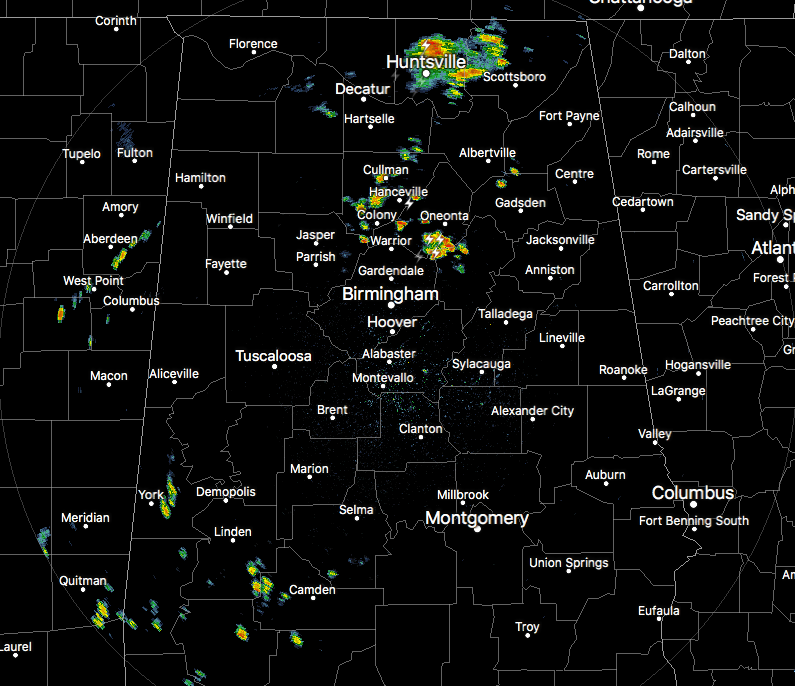
As of 11:30 am, we already have some scattered showers and thunderstorms affecting parts of Central Alabama, mainly over portions of Cullman, Blount, and St. Clair counties, along with a few isolated showers over central parts of Sumter County. At this point, nothing seems to be strong, but that could change as we get deeper into the heating of the day. Also, there is a cluster of storms affecting Madison and Jackson counties at the moment as well. All of these are moving to the northeast.
It’s already a warm one out there with temperatures in the 70s to the lower 80s across the area. The cool spot was Haleyville at 72 degrees. The warm spot was Troy at 83 degrees. Birmingham was sitting at 80 degrees.
We’ll have a decent chance of scattered showers and thunderstorms throughout the afternoon and evening hours, some of which could be rather strong. The latest Hazardous Weather Outlook from NWS Birmingham states that there will be a potential for isolated severe storms from 12:00 pm to 8:00 pm today across all of Central Alabama. Damaging winds up to 60 MPH and large hail will be the primary threats. Afternoon highs will be in the mid-80s to the lower 90s. For tonight, those showers and storms will decrease in coverage during the evening hours, with most coming to an end by the late local news. Some patchy dense fog may be possible where rain occurs during the evening. Lows will be in the mid to upper 60s.
We’ll start Sunday off with a good bit of sun but convective clouds will begin to build during the heating of the day. Scattered afternoon to early evening showers and storms will be possible again. A few may be strong with gusty winds. Highs will be in the mid-80s to the lower 90s across the area from northwest to southeast.
A near rinse and repeat forecast for Monday as we’ll start with a good bit of sunshine, but the afternoon heat will bring developing convective clouds and the chance of scattered showers and thunderstorms. Highs will be in the mid-80s to the lower 90s across the area from northwest to southeast.
Category: Alabama's Weather, ALL POSTS, Severe Weather
About the Author (Author Profile)
Scott Martin is an operational meteorologist, professional graphic artist, musician, husband, and father. Not only is Scott a member of the National Weather Association, but he is also the Central Alabama Chapter of the NWA president. Scott is also the co-founder of Racecast Weather, which provides forecasts for many racing series across the USA. He also supplies forecasts for the BassMaster Elite Series events including the BassMaster Classic.Subscribe
If you enjoyed this article, subscribe to receive more just like it.


